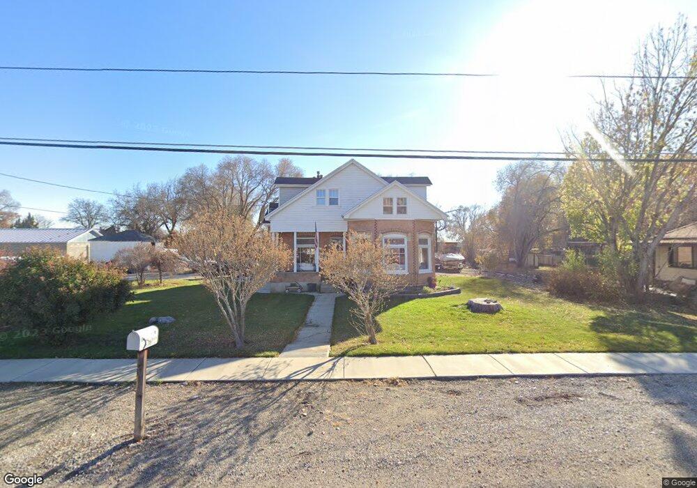
41 W 100 S American Fork, UT 84003
Estimated Value: $654,182 - $853,000
5
Beds
3
Baths
3,101
Sq Ft
$230/Sq Ft
Est. Value
About This Home
This home is located at 41 W 100 S, American Fork, UT 84003 and is currently estimated at $711,796, approximately $229 per square foot. 41 W 100 S is a home located in Utah County with nearby schools including Greenwood Elementary School, American Fork Junior High School, and American Fork High School.
Ownership History
Date
Name
Owned For
Owner Type
Purchase Details
Closed on
Jul 18, 2022
Sold by
Paul Brady
Bought by
Brady Paul and Brady Melinda
Current Estimated Value
Home Financials for this Owner
Home Financials are based on the most recent Mortgage that was taken out on this home.
Original Mortgage
$459,000
Outstanding Balance
$439,182
Interest Rate
5.78%
Mortgage Type
VA
Estimated Equity
$272,614
Purchase Details
Closed on
Nov 5, 2020
Sold by
Brady Paul
Bought by
Brady Paul and Brady Melinda
Home Financials for this Owner
Home Financials are based on the most recent Mortgage that was taken out on this home.
Original Mortgage
$339,720
Interest Rate
2.9%
Mortgage Type
VA
Purchase Details
Closed on
Dec 2, 2019
Sold by
Brady Paul
Bought by
Brady Paul and Brady Melinda
Home Financials for this Owner
Home Financials are based on the most recent Mortgage that was taken out on this home.
Original Mortgage
$339,500
Interest Rate
3.75%
Mortgage Type
VA
Purchase Details
Closed on
Aug 12, 2019
Sold by
Brady Paul Louis
Bought by
Brady Paul and Brady Melinda L
Purchase Details
Closed on
Feb 27, 2019
Sold by
Brady Paul Louis and Brady Melinda L
Bought by
Brady Paul Louis
Home Financials for this Owner
Home Financials are based on the most recent Mortgage that was taken out on this home.
Original Mortgage
$339,500
Interest Rate
4.4%
Mortgage Type
VA
Purchase Details
Closed on
Feb 13, 2019
Sold by
Ellis Kathleen and Brady Kathleen
Bought by
Brady Paul Louis
Home Financials for this Owner
Home Financials are based on the most recent Mortgage that was taken out on this home.
Original Mortgage
$339,500
Interest Rate
4.4%
Mortgage Type
VA
Purchase Details
Closed on
Oct 20, 2011
Sold by
Brady Paul Louis
Bought by
Brady Paul Louis and Brady Melinda L
Purchase Details
Closed on
Jun 16, 1999
Sold by
Brady Kathleen W
Bought by
Brady Paul Louis
Home Financials for this Owner
Home Financials are based on the most recent Mortgage that was taken out on this home.
Original Mortgage
$192,850
Interest Rate
7.01%
Create a Home Valuation Report for This Property
The Home Valuation Report is an in-depth analysis detailing your home's value as well as a comparison with similar homes in the area
Home Values in the Area
Average Home Value in this Area
Purchase History
| Date | Buyer | Sale Price | Title Company |
|---|---|---|---|
| Brady Paul | -- | Utah First Title | |
| Brady Paul | -- | Accommodation | |
| Brady Paul | -- | Highland Title | |
| Brady Paul | -- | Accommodation | |
| Brady Paul | -- | Highland Title | |
| Brady Paul | -- | Vanguard Title Ins Agcy Llc | |
| Brady Paul Louis | -- | Highland Title | |
| Brady Paul Louis | -- | Highland Title | |
| Brady Paul Louis | -- | Access Title Company | |
| Brady Paul Louis | -- | Fidelity Land & Title |
Source: Public Records
Mortgage History
| Date | Status | Borrower | Loan Amount |
|---|---|---|---|
| Open | Brady Paul | $459,000 | |
| Previous Owner | Brady Paul | $339,720 | |
| Previous Owner | Brady Paul | $339,500 | |
| Previous Owner | Brady Paul Louis | $339,500 | |
| Previous Owner | Brady Paul Louis | $192,850 |
Source: Public Records
Tax History Compared to Growth
Tax History
| Year | Tax Paid | Tax Assessment Tax Assessment Total Assessment is a certain percentage of the fair market value that is determined by local assessors to be the total taxable value of land and additions on the property. | Land | Improvement |
|---|---|---|---|---|
| 2025 | $2,863 | $344,685 | $248,400 | $378,300 |
| 2024 | $2,601 | $318,120 | $0 | $0 |
| 2023 | $556 | $306,405 | $0 | $0 |
| 2022 | $556 | $291,775 | $0 | $0 |
| 2021 | $2,145 | $389,500 | $178,300 | $211,200 |
| 2020 | $1,813 | $353,000 | $159,200 | $193,800 |
| 2019 | $1,813 | $330,200 | $136,400 | $193,800 |
| 2018 | $1,734 | $302,000 | $122,800 | $179,200 |
| 2017 | $1,603 | $150,700 | $0 | $0 |
| 2016 | $1,398 | $122,045 | $0 | $0 |
| 2015 | $1,399 | $115,940 | $0 | $0 |
| 2014 | $1,388 | $113,465 | $0 | $0 |
Source: Public Records
Map
Nearby Homes
- 195 S Center St
- 55 S 200 W
- 129 W Pacific Dr
- 105 N 100 W
- 65 E 400 S Unit 8
- 271 S Barratt Cir
- 351 Washington Ave
- 57 W 200 N
- Evergreen Plan at Storrs Court
- Juniper Plan at Storrs Court
- Redwood Plan at Storrs Court
- Ashwood Plan at Storrs Court
- 148 N 100 E
- 126 S 300 E
- 82 S Lincoln Ave
- 146 N Grant Ave
- 336 S 300 E
- 382 W 330 S
- 316 W 390 S
- 429 S Storrs Ave