
Seller's Agent in 2025
Blood Team Realty Group
Keller Williams Realty - Merrimack
(978) 433-8800
68 in this area
595 Total Sales
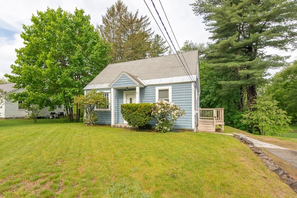
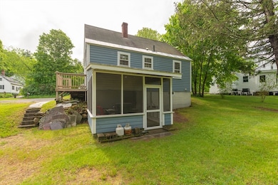
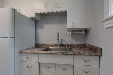
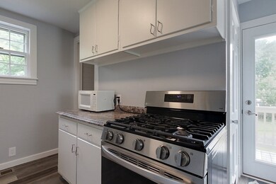


Charming and updated Cape with cottage vibes! Tucked just off Route 119 for easy access to town and minutes from the MA/NH border, this delightful home offers both style, comfort and great location. Enter through the side deck into a quaint galley Kitchen with a newer stove (2021) and updated flooring that flows into the hall, Full Bath, and first-floor Bedroom. The right side of the home features a spacious open-concept Dining/Living Room with hardwood floors, built-in shelving, and a cozy window seat. Upstairs, 2 Bedrooms (pass-through style) boast fresh Nickel Gap paneling for a warm, cottage feel. Over 500 sq ft of basement storage/workshop space. Freshly repainted in light neutrals throughout with a new hot water heater. Enjoy the serene screened porch overlooking a private backyard with firepit and mature trees. A perfect spot for first-time buyers, downsizers, or anyone seeking charm and simplicity. Highest and best offers due Tuesday 6/3/25 by 5pm. Allow 24 hours for response
Last Agent to Sell the Property
Keller Williams Realty - Merrimack Listed on: 05/27/2025
| Date | Type | Sale Price | Title Company |
|---|---|---|---|
| Quit Claim Deed | $345,000 | -- | |
| Quit Claim Deed | $345,000 | -- | |
| Quit Claim Deed | -- | -- | |
| Quit Claim Deed | -- | -- | |
| Land Court Massachusetts | $186,000 | -- | |
| Land Court Massachusetts | $186,000 | -- | |
| Land Court Massachusetts | $186,000 | -- | |
| Deed | -- | -- | |
| Deed | -- | -- | |
| Deed | -- | -- |
| Date | Status | Loan Amount | Loan Type |
|---|---|---|---|
| Open | $310,500 | New Conventional | |
| Closed | $310,500 | New Conventional | |
| Previous Owner | $37,200 | Purchase Money Mortgage |
| Date | Event | Price | List to Sale | Price per Sq Ft |
|---|---|---|---|---|
| 07/10/2025 07/10/25 | Sold | $345,000 | +15.4% | $331 / Sq Ft |
| 06/04/2025 06/04/25 | Pending | -- | -- | -- |
| 05/27/2025 05/27/25 | For Sale | $299,000 | -- | $287 / Sq Ft |
| Year | Tax Paid | Tax Assessment Tax Assessment Total Assessment is a certain percentage of the fair market value that is determined by local assessors to be the total taxable value of land and additions on the property. | Land | Improvement |
|---|---|---|---|---|
| 2025 | $4,607 | $317,300 | $88,700 | $228,600 |
| 2024 | $4,487 | $311,400 | $88,700 | $222,700 |
| 2023 | $4,489 | $294,200 | $80,700 | $213,500 |
| 2022 | $4,388 | $249,200 | $70,200 | $179,000 |
| 2021 | $4,216 | $230,000 | $69,400 | $160,600 |
| 2020 | $4,054 | $207,700 | $61,700 | $146,000 |
| 2019 | $3,876 | $200,500 | $61,700 | $138,800 |
| 2018 | $3,762 | $185,700 | $61,700 | $124,000 |
| 2017 | $3,580 | $182,000 | $65,700 | $116,300 |
| 2016 | $3,427 | $173,100 | $65,700 | $107,400 |
| 2015 | $3,283 | $171,800 | $68,600 | $103,200 |
| 2014 | $3,041 | $155,400 | $61,700 | $93,700 |
Seller's Agent in 2025
Blood Team Realty Group
Keller Williams Realty - Merrimack
(978) 433-8800
68 in this area
595 Total Sales
J
Buyer's Agent in 2025
Jim Holbrook
Berkshire Hathaway HomeServices Commonwealth Real Estate
(508) 624-6470
1 in this area
65 Total Sales
Source: MLS Property Information Network (MLS PIN)
MLS Number: 73380353
APN: TOWN-000047-000006
Disclaimer: Certain information contained herein is derived from information provided by parties other than Homes.com. All information provided is deemed reliable, but is not guaranteed to be accurate and should be independently verified.
![]() The property listing data and information, or the Images, set forth herein were provided to MLS Property Information Network, Inc. from third party sources, including sellers, lessors and public records, and were compiled by MLS Property Information Network, Inc. The property listing data and information, and the Images, are for the personal, non-commercial use of consumers having a good faith interest in purchasing or leasing listed properties of the type displayed to them and may not be used for any purpose other than to identify prospective properties which such consumers may have a good faith interest in purchasing or leasing. MLS Property Information Network, Inc. and its subscribers disclaim any and all representations and warranties as to the accuracy of the property listing data and information, or as to the accuracy of any of the Images, set forth herein.
The property listing data and information, or the Images, set forth herein were provided to MLS Property Information Network, Inc. from third party sources, including sellers, lessors and public records, and were compiled by MLS Property Information Network, Inc. The property listing data and information, and the Images, are for the personal, non-commercial use of consumers having a good faith interest in purchasing or leasing listed properties of the type displayed to them and may not be used for any purpose other than to identify prospective properties which such consumers may have a good faith interest in purchasing or leasing. MLS Property Information Network, Inc. and its subscribers disclaim any and all representations and warranties as to the accuracy of the property listing data and information, or as to the accuracy of any of the Images, set forth herein.