
Seller's Agent in 2025
Stephen Archino
Sotheby's International Realty
(203) 964-7445
12 in this area
116 Total Sales
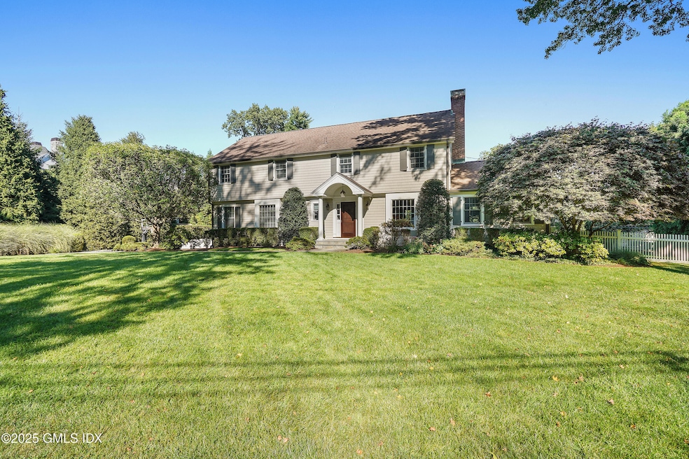


Discover the charm of this picture-perfect colonial home, nestled in one of the most coveted cul-de-sacs in Riverside, Greenwich. This stunning residence offers an exceptional layout, featuring 4 spacious bedrooms, 4 full, and 1 half baths, ensuring ample comfort for family and guests. The heart of the home is the beautifully designed kitchen that opens to a light-filled family room, creating an inviting space for gatherings. This home is in impeccable, move-in ready condition, complete with a delightful recreation room in the lower level for entertainment or relaxation. Enjoy the beautifully landscaped private yard, ideal for outdoor gatherings or peaceful solitude. Located just minutes from top-rated elementary and junior high schools, the train station, and scenic Binney Park, this home also offers easy access to the picturesque town of Old Greenwich and Tod's Point Beach. Don't miss this opportunity to own a piece of paradise in a prime location!
Last Agent to Sell the Property
Sotheby's International Realty License #RES.0018044 Listed on: 09/11/2025
| Date | Type | Sale Price | Title Company |
|---|---|---|---|
| Warranty Deed | $1,500,000 | -- |
| Date | Status | Loan Amount | Loan Type |
|---|---|---|---|
| Open | $601,450 | Unknown | |
| Closed | $700,000 | No Value Available | |
| Closed | $1,000,000 | No Value Available | |
| Closed | $1,000,000 | No Value Available |
| Date | Event | Price | List to Sale | Price per Sq Ft |
|---|---|---|---|---|
| 12/01/2025 12/01/25 | Sold | $3,450,000 | +0.7% | $1,029 / Sq Ft |
| 10/02/2025 10/02/25 | Pending | -- | -- | -- |
| 09/29/2025 09/29/25 | Price Changed | $3,425,000 | -12.1% | $1,022 / Sq Ft |
| 09/11/2025 09/11/25 | For Sale | $3,895,000 | -- | $1,162 / Sq Ft |
| Year | Tax Paid | Tax Assessment Tax Assessment Total Assessment is a certain percentage of the fair market value that is determined by local assessors to be the total taxable value of land and additions on the property. | Land | Improvement |
|---|---|---|---|---|
| 2025 | $17,720 | $1,433,810 | $1,006,180 | $427,630 |
| 2024 | $17,114 | $1,433,810 | $1,006,180 | $427,630 |
| 2023 | $16,684 | $1,433,810 | $1,006,180 | $427,630 |
| 2022 | $16,532 | $1,433,810 | $1,006,180 | $427,630 |
| 2021 | $16,733 | $1,389,780 | $928,760 | $461,020 |
| 2020 | $16,705 | $1,389,780 | $928,760 | $461,020 |
| 2019 | $16,872 | $1,389,780 | $928,760 | $461,020 |
| 2018 | $16,497 | $1,389,780 | $928,760 | $461,020 |
| 2017 | $16,704 | $1,389,780 | $928,760 | $461,020 |
| 2016 | $16,440 | $1,389,780 | $928,760 | $461,020 |
| 2015 | $12,666 | $1,062,180 | $800,100 | $262,080 |
| 2014 | $12,348 | $1,062,180 | $800,100 | $262,080 |
Seller's Agent in 2025
Stephen Archino
Sotheby's International Realty
(203) 964-7445
12 in this area
116 Total Sales
Buyer's Agent in 2025
Adam Mariucci
Compass Connecticut, LLC
(408) 596-0497
1 in this area
6 Total Sales
Source: Greenwich Association of REALTORS®
MLS Number: 123528
APN: GREE-000005-000000-002318-S000000
Disclaimer: Certain information contained herein is derived from information provided by parties other than Homes.com. All information provided is deemed reliable, but is not guaranteed to be accurate and should be independently verified.
![]() Listing data courtesy of Greenwich MLS. IDX information is provided exclusively for consumers’ personal, non-commercial use, that it may not be used for any purpose other than to
Listing data courtesy of Greenwich MLS. IDX information is provided exclusively for consumers’ personal, non-commercial use, that it may not be used for any purpose other than to
identify prospective properties consumers may be interested in purchasing. Data is deemed reliable but is not guaranteed accurate by the MLS.
Ask me questions while you tour the home.