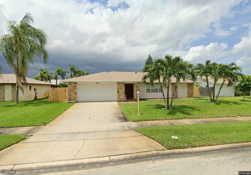
410 Carriage Rd Satellite Beach, FL 32937
Estimated Value: $573,000 - $658,000
4
Beds
2
Baths
1,954
Sq Ft
$317/Sq Ft
Est. Value
About This Home
This home is located at 410 Carriage Rd, Satellite Beach, FL 32937 and is currently estimated at $619,896, approximately $317 per square foot. 410 Carriage Rd is a home located in Brevard County with nearby schools including Surfside Elementary School, Satellite Senior High School, and DeLaura Middle School.
Ownership History
Date
Name
Owned For
Owner Type
Purchase Details
Closed on
Feb 20, 2025
Sold by
Hoff Charles M
Bought by
Hoff Charles M and Hoff Paula
Current Estimated Value
Purchase Details
Closed on
May 18, 2001
Sold by
Ennis Charles M and Ennis Julie M
Bought by
Hoff Mary J and Delanoy Irene H
Purchase Details
Closed on
Sep 30, 1997
Sold by
Cain Gene W and Cain Carolyn
Bought by
Ennis Charles M and Ennis Julie M
Purchase Details
Closed on
Aug 27, 1993
Sold by
Smith George D and Smith Sarah E
Bought by
Cain Gene W and Cain Carolyn
Home Financials for this Owner
Home Financials are based on the most recent Mortgage that was taken out on this home.
Original Mortgage
$146,000
Interest Rate
7.21%
Create a Home Valuation Report for This Property
The Home Valuation Report is an in-depth analysis detailing your home's value as well as a comparison with similar homes in the area
Home Values in the Area
Average Home Value in this Area
Purchase History
| Date | Buyer | Sale Price | Title Company |
|---|---|---|---|
| Hoff Charles M | $100 | None Listed On Document | |
| Hoff Charles M | $100 | None Listed On Document | |
| Hoff Mary J | $187,000 | -- | |
| Ennis Charles M | $155,000 | -- | |
| Cain Gene W | $146,000 | -- |
Source: Public Records
Mortgage History
| Date | Status | Borrower | Loan Amount |
|---|---|---|---|
| Previous Owner | Cain Gene W | $146,000 |
Source: Public Records
Tax History Compared to Growth
Tax History
| Year | Tax Paid | Tax Assessment Tax Assessment Total Assessment is a certain percentage of the fair market value that is determined by local assessors to be the total taxable value of land and additions on the property. | Land | Improvement |
|---|---|---|---|---|
| 2025 | $8,604 | $501,400 | -- | -- |
| 2024 | $8,188 | $513,730 | -- | -- |
| 2023 | $8,188 | $496,020 | $0 | $0 |
| 2022 | $7,237 | $455,100 | $0 | $0 |
| 2021 | $6,542 | $321,990 | $138,000 | $183,990 |
| 2020 | $6,245 | $302,380 | $125,000 | $177,380 |
| 2019 | $2,639 | $160,600 | $0 | $0 |
| 2018 | $2,638 | $157,610 | $0 | $0 |
| 2017 | $2,468 | $154,370 | $0 | $0 |
| 2016 | $2,473 | $151,200 | $85,000 | $66,200 |
| 2015 | $2,532 | $150,150 | $75,000 | $75,150 |
| 2014 | $2,534 | $148,960 | $70,000 | $78,960 |
Source: Public Records
Map
Nearby Homes
- 431 E Amherst Cir
- 445 Saint Johns Dr
- 435 Desoto Pkwy
- 302 Markley Ct
- 502 Bay Cir
- 550 Temple St
- 620 Jamaica Blvd
- 368 Ocean Spray Ave
- 426 Hawthorne Ct Unit G2
- 366 Ocean Spray Ave
- 527 Summerset Ct
- 484 Greenway Ave
- 443 Hawthorne Ct
- 370 Cinnamon Dr
- 690 Trinidad Ct
- 295 Cinnamon Dr
- 105 Carissa Dr
- 235 S Marco Way
- 199 Skyline Ct
- 210 Queens Ct