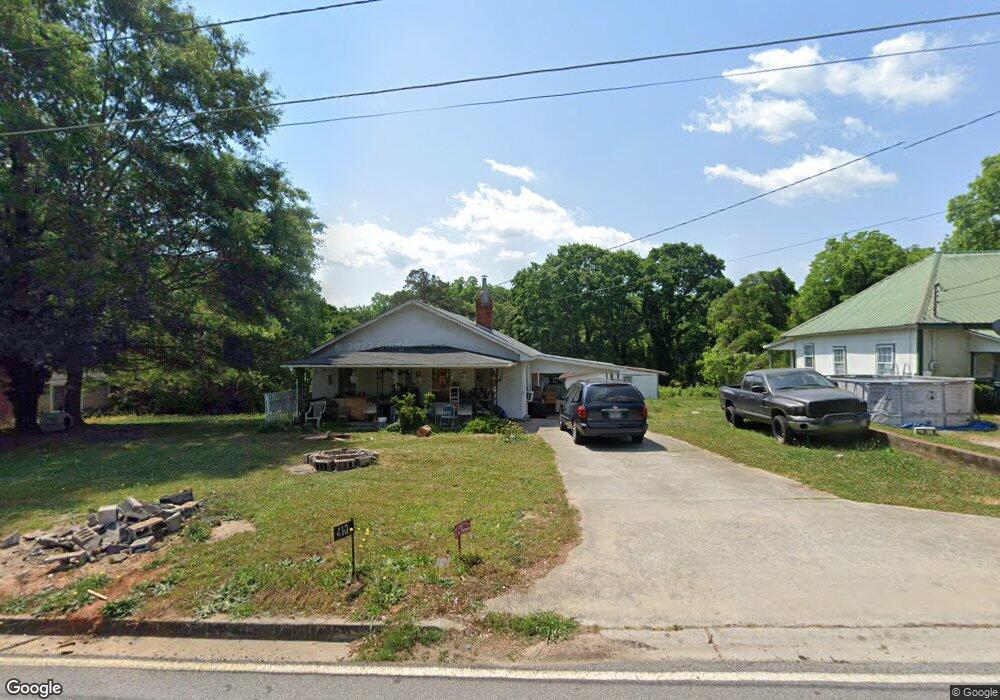
410 Davis Ave Toccoa, GA 30577
Estimated Value: $107,000 - $157,000
1
Bed
1
Bath
1,208
Sq Ft
$107/Sq Ft
Est. Value
About This Home
This home is located at 410 Davis Ave, Toccoa, GA 30577 and is currently estimated at $129,325, approximately $107 per square foot. 410 Davis Ave is a home located in Stephens County with nearby schools including Stephens County High School.
Ownership History
Date
Name
Owned For
Owner Type
Purchase Details
Closed on
May 15, 2014
Sold by
Jtre Llc
Bought by
Jakets Holdings Llc
Current Estimated Value
Purchase Details
Closed on
Oct 9, 2009
Sold by
Randall Jane F
Bought by
Jtre
Home Financials for this Owner
Home Financials are based on the most recent Mortgage that was taken out on this home.
Original Mortgage
$30,000
Interest Rate
5.03%
Mortgage Type
New Conventional
Purchase Details
Closed on
Apr 1, 1995
Bought by
<Buyer Info Not Present>
Purchase Details
Closed on
Aug 1, 1992
Bought by
<Buyer Info Not Present>
Create a Home Valuation Report for This Property
The Home Valuation Report is an in-depth analysis detailing your home's value as well as a comparison with similar homes in the area
Purchase History
| Date | Buyer | Sale Price | Title Company |
|---|---|---|---|
| Jakets Holdings Llc | -- | -- | |
| Jtre | $35,000 | -- | |
| Jtre | $35,000 | -- | |
| <Buyer Info Not Present> | -- | -- | |
| <Buyer Info Not Present> | -- | -- |
Source: Public Records
Mortgage History
| Date | Status | Borrower | Loan Amount |
|---|---|---|---|
| Previous Owner | Jtre | $30,000 |
Source: Public Records
Tax History
| Year | Tax Paid | Tax Assessment Tax Assessment Total Assessment is a certain percentage of the fair market value that is determined by local assessors to be the total taxable value of land and additions on the property. | Land | Improvement |
|---|---|---|---|---|
| 2025 | $910 | $26,092 | $1,744 | $24,348 |
| 2024 | $642 | $17,995 | $1,744 | $16,251 |
| 2023 | $596 | $16,848 | $1,744 | $15,104 |
| 2022 | $401 | $13,460 | $1,744 | $11,716 |
| 2021 | $392 | $12,529 | $1,744 | $10,785 |
| 2020 | $399 | $12,647 | $1,744 | $10,903 |
| 2019 | $401 | $12,647 | $1,744 | $10,903 |
| 2018 | $403 | $12,695 | $1,792 | $10,903 |
| 2017 | $409 | $16,977 | $1,792 | $15,185 |
| 2016 | $538 | $16,976 | $1,792 | $15,184 |
| 2015 | $563 | $16,947 | $1,792 | $15,155 |
| 2014 | $571 | $16,912 | $1,792 | $15,120 |
| 2013 | -- | $16,912 | $1,792 | $15,120 |
Source: Public Records
Map
Nearby Homes
Your Personal Tour Guide
Ask me questions while you tour the home.