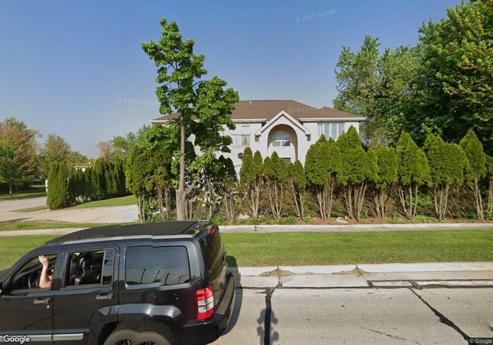
410 N Roselle Rd Roselle, IL 60172
Estimated Value: $705,000 - $955,343
4
Beds
6
Baths
3,708
Sq Ft
$224/Sq Ft
Est. Value
About This Home
This home is located at 410 N Roselle Rd, Roselle, IL 60172 and is currently estimated at $830,836, approximately $224 per square foot. 410 N Roselle Rd is a home located in Cook County with nearby schools including Edwin Aldrin Elementary School, Robert Frost Junior High School, and J B Conant High School.
Ownership History
Date
Name
Owned For
Owner Type
Purchase Details
Closed on
May 14, 2009
Sold by
Tawfic Nabil and Hanna Marie
Bought by
Tawfic Nabil E and Hanna Marie M
Current Estimated Value
Purchase Details
Closed on
Mar 22, 2004
Sold by
Tawfic Nabil
Bought by
Tawfic Nabil and Hanna Marie
Purchase Details
Closed on
May 23, 1994
Sold by
Patel Kantibhai F and Patel Gitaben K
Bought by
Tawfic Nabil
Create a Home Valuation Report for This Property
The Home Valuation Report is an in-depth analysis detailing your home's value as well as a comparison with similar homes in the area
Home Values in the Area
Average Home Value in this Area
Purchase History
| Date | Buyer | Sale Price | Title Company |
|---|---|---|---|
| Tawfic Nabil E | -- | Ticor Title Insurance Co | |
| Tawfic Nabil | -- | Chicago Title Insurance Comp | |
| Tawfic Nabil | $62,500 | -- |
Source: Public Records
Tax History Compared to Growth
Tax History
| Year | Tax Paid | Tax Assessment Tax Assessment Total Assessment is a certain percentage of the fair market value that is determined by local assessors to be the total taxable value of land and additions on the property. | Land | Improvement |
|---|---|---|---|---|
| 2024 | $16,276 | $63,000 | $11,872 | $51,128 |
| 2023 | $15,683 | $63,000 | $11,872 | $51,128 |
| 2022 | $15,683 | $63,000 | $11,872 | $51,128 |
| 2021 | $14,446 | $52,122 | $8,533 | $43,589 |
| 2020 | $14,287 | $52,122 | $8,533 | $43,589 |
| 2019 | $14,213 | $57,914 | $8,533 | $49,381 |
| 2018 | $13,011 | $48,281 | $7,049 | $41,232 |
| 2017 | $12,796 | $48,281 | $7,049 | $41,232 |
| 2016 | $13,104 | $51,641 | $7,049 | $44,592 |
| 2015 | $12,222 | $44,722 | $5,936 | $38,786 |
| 2014 | $13,490 | $49,990 | $5,936 | $44,054 |
| 2013 | $13,060 | $49,990 | $5,936 | $44,054 |
Source: Public Records
Map
Nearby Homes
- 207 Schreiber Ave
- 533 Seward St
- 325 Williams St
- 1738 Lincoln St
- 27 E Hattendorf Ave Unit 216
- 23W662 Irving Park Rd
- 50 N Bokelman St Unit 333
- 1630 Myrtle Park St
- 1630 Myrtle Park St
- 1630 Myrtle Park St
- 375 W Devon Ave
- 225 Main St Unit 201
- 225 Main St Unit 205
- 1520 Grant St
- 1342 Lunt Ct Unit 56
- 560 Lawrence Ave Unit 307
- 124 E Monterey Ave
- 542 Bryce Trail
- 30 Wildwood Dr
- 357 Lucille Ln Unit 30
- 16 W Devon Ave
- 420 N Roselle Rd
- 15 Schreiber Ave
- 24 W Devon Ave
- 350 N Roselle Rd
- 23 Schreiber Ave
- 489 N Roselle Rd
- 32 W Devon Ave
- 31 Schreiber Ave
- 19 W Devon Ave
- 346 N Roselle Rd
- 459 N Roselle Rd
- 23 W Devon Ave
- 40 W Devon Ave
- 27 W Devon Ave
- 1900 S Roselle Rd
- 1900 S Roselle Rd
- 39 Schreiber Ave
- 338 N Roselle Rd
- 405 N Roselle Rd