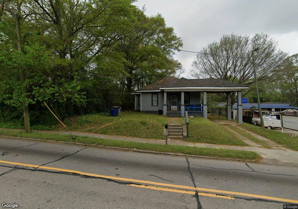
410 Whitesville St Lagrange, GA 30240
Estimated Value: $59,000 - $146,000
3
Beds
2
Baths
1,068
Sq Ft
$109/Sq Ft
Est. Value
About This Home
This home is located at 410 Whitesville St, Lagrange, GA 30240 and is currently estimated at $116,346, approximately $108 per square foot. 410 Whitesville St is a home located in Troup County with nearby schools including Hollis Hand Elementary School, Franklin Forest Elementary School, and Ethel W. Kight Elementary School.
Ownership History
Date
Name
Owned For
Owner Type
Purchase Details
Closed on
Jul 3, 2014
Sold by
Veal Kathy D
Bought by
Riley Maxwell
Current Estimated Value
Purchase Details
Closed on
May 15, 2008
Sold by
Bishop A L
Bought by
Lee Tim
Purchase Details
Closed on
Apr 13, 1981
Sold by
Jackson Ted M and Jackson Glen W
Bought by
Bishop A L
Purchase Details
Closed on
Feb 18, 1977
Sold by
Spinks John Roy Iii Etal
Bought by
Jackson Ted M and Jackson Glen W
Purchase Details
Closed on
Mar 19, 1976
Sold by
Teaver Hershel Wyolene
Bought by
Spinks John Roy Iii Etal
Purchase Details
Closed on
Jan 1, 1972
Sold by
Teaver Thomas
Bought by
Teaver Hershel Wyolene
Purchase Details
Closed on
Jun 1, 1936
Bought by
Teaver Thomas
Create a Home Valuation Report for This Property
The Home Valuation Report is an in-depth analysis detailing your home's value as well as a comparison with similar homes in the area
Home Values in the Area
Average Home Value in this Area
Purchase History
| Date | Buyer | Sale Price | Title Company |
|---|---|---|---|
| Riley Maxwell | $75,000 | -- | |
| Lee Tim | $170,000 | -- | |
| Bishop A L | $16,200 | -- | |
| Jackson Ted M | $22,000 | -- | |
| Spinks John Roy Iii Etal | -- | -- | |
| Teaver Hershel Wyolene | -- | -- | |
| Teaver Thomas | -- | -- |
Source: Public Records
Tax History Compared to Growth
Tax History
| Year | Tax Paid | Tax Assessment Tax Assessment Total Assessment is a certain percentage of the fair market value that is determined by local assessors to be the total taxable value of land and additions on the property. | Land | Improvement |
|---|---|---|---|---|
| 2024 | $945 | $34,640 | $8,040 | $26,600 |
| 2023 | $878 | $32,200 | $8,040 | $24,160 |
| 2022 | $863 | $30,920 | $8,040 | $22,880 |
| 2021 | $501 | $16,600 | $3,320 | $13,280 |
| 2020 | $501 | $16,600 | $3,320 | $13,280 |
| 2019 | $475 | $15,760 | $3,320 | $12,440 |
| 2018 | $466 | $15,440 | $3,000 | $12,440 |
| 2017 | $466 | $15,440 | $3,000 | $12,440 |
| 2016 | $459 | $15,205 | $3,000 | $12,205 |
| 2015 | $272 | $9,000 | $1,938 | $7,062 |
| 2014 | $637 | $21,044 | $3,332 | $17,712 |
| 2013 | -- | $22,386 | $3,332 | $19,054 |
Source: Public Records
Map
Nearby Homes
- 501 Milam St
- 303 E Mulberry St
- W W Crovat St
- 203 Fannin St
- 205 Fannin St
- 206 Peachtree St
- 109 Bell St
- 101 Cedar St
- 516 S Lewis St
- 509 S Lewis St
- 505 S Lewis St
- 0 Bagley St
- 0 Boggs St Unit 10550243
- 0 Boggs St Unit 10550231
- 0 Boggs St Unit 10550239
- 0 Boggs St Unit 10550250
- 0 E Fendig St
- 113 E Fendig St
- 901 Whiteline St
- 304 Butler St
- 404 Whitesville St
- 414 Whitesville St
- 104 W Cannon St
- 106 W Cannon St
- 409 Milam St
- 402 Whitesville St
- 409 Whitesville Rd
- 407 Whitesville St
- 108 W Cannon St
- 101 W Cannon St
- 400 Whitesville St
- 213 W Mulberry St
- 401 Milam St
- 409 Whitesville St
- 110 W Cannon St
- 103 W Cannon St
- 403 Whitesville St
- 105 W Cannon St
- 211 W Mulberry St
- 406 Whitesville St