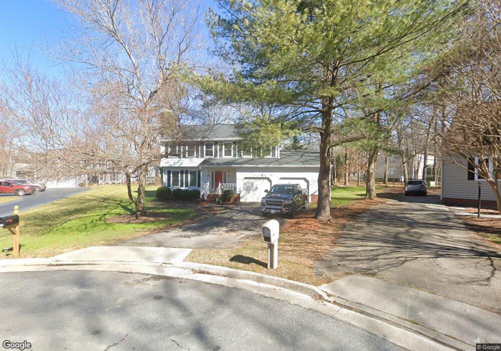
4100 Heathstead Ct Chester, VA 23831
Estimated Value: $374,822 - $420,000
4
Beds
3
Baths
2,248
Sq Ft
$177/Sq Ft
Est. Value
About This Home
This home is located at 4100 Heathstead Ct, Chester, VA 23831 and is currently estimated at $397,206, approximately $176 per square foot. 4100 Heathstead Ct is a home located in Chesterfield County with nearby schools including C E Curtis Elementary School, Bellwood Elementary School, and Elizabeth Davis Middle School.
Ownership History
Date
Name
Owned For
Owner Type
Purchase Details
Closed on
Jan 9, 2002
Bought by
Ragsdale Tilda
Current Estimated Value
Home Financials for this Owner
Home Financials are based on the most recent Mortgage that was taken out on this home.
Original Mortgage
$13,800
Outstanding Balance
$5,639
Interest Rate
7.04%
Mortgage Type
New Conventional
Estimated Equity
$391,567
Create a Home Valuation Report for This Property
The Home Valuation Report is an in-depth analysis detailing your home's value as well as a comparison with similar homes in the area
Home Values in the Area
Average Home Value in this Area
Purchase History
| Date | Buyer | Sale Price | Title Company |
|---|---|---|---|
| Ragsdale Tilda | -- | -- |
Source: Public Records
Mortgage History
| Date | Status | Borrower | Loan Amount |
|---|---|---|---|
| Open | Ragsdale Tilda | $13,800 |
Source: Public Records
Tax History
| Year | Tax Paid | Tax Assessment Tax Assessment Total Assessment is a certain percentage of the fair market value that is determined by local assessors to be the total taxable value of land and additions on the property. | Land | Improvement |
|---|---|---|---|---|
| 2025 | $3,348 | $373,400 | $62,000 | $311,400 |
| 2024 | $3,348 | $361,500 | $60,000 | $301,500 |
| 2023 | $2,778 | $305,300 | $56,000 | $249,300 |
| 2022 | $2,627 | $285,500 | $52,000 | $233,500 |
| 2021 | $2,506 | $261,200 | $47,000 | $214,200 |
| 2020 | $2,232 | $234,900 | $44,000 | $190,900 |
| 2019 | $2,309 | $243,100 | $44,000 | $199,100 |
| 2018 | $2,196 | $231,200 | $44,000 | $187,200 |
| 2017 | $2,156 | $224,600 | $44,000 | $180,600 |
| 2016 | $2,127 | $221,600 | $44,000 | $177,600 |
| 2015 | $2,087 | $214,800 | $44,000 | $170,800 |
| 2014 | $1,933 | $198,700 | $44,000 | $154,700 |
Source: Public Records
Map
Nearby Homes
- 11219 Chester Rd
- 3856 Randall Dr
- 3719 Vanhorn Ct
- 10513 Centralia Station Rd
- 11118 Sparwood Rd
- 5130 Vulcan Ct
- 11219 Sparwood Rd
- 3601 E Chagford Terrace
- 10419 Centralia Station Rd
- 4824 Mcallister Dr
- 11325 Vulcan Ln
- 4906 Mcallister Dr
- 4301 Village Creek Dr
- 10401 Hamlin Place
- 10906 Timonium Dr
- 4612 Chippoke Rd
- 10818 Timonium Dr
- 10807 Wellington Cross Way
- 4401 Village Garden Cir
- 9901 Ethens Castle Dr
- 11108 Kentshire Ln
- 4102 Heathstead Ct
- 4101 Heathstead Ct
- 11106 Kentshire Ln
- 4104 Heathstead Ct
- 11110 Kentshire Ln
- 4103 Heathstead Ct
- 11104 Kentshire Ln
- 11105 Heathstead Rd
- 11103 Heathstead Rd
- 4107 Heathstead Ct
- 4105 Heathstead Ct
- 11111 Kentshire Ln
- 4105 Paces Ferry Rd
- 4103 Paces Ferry Rd
- 11203 Heathstead Rd
- 4107 Paces Ferry Rd
- 11100 Kentshire Ln
- 11223 Chester Rd
- 11107 Kentshire Ln
Your Personal Tour Guide
Ask me questions while you tour the home.