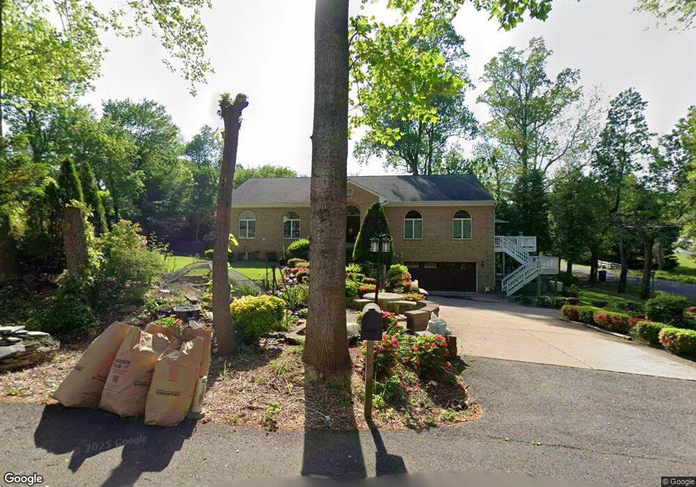
4100 High Point Ct Annandale, VA 22003
Estimated Value: $1,194,443 - $1,329,000
4
Beds
4
Baths
3,287
Sq Ft
$389/Sq Ft
Est. Value
About This Home
This home is located at 4100 High Point Ct, Annandale, VA 22003 and is currently estimated at $1,279,361, approximately $389 per square foot. 4100 High Point Ct is a home located in Fairfax County with nearby schools including Wakefield Forest Elementary School, Frost Middle School, and W. T. Woodson High School.
Ownership History
Date
Name
Owned For
Owner Type
Purchase Details
Closed on
May 9, 2025
Sold by
Ramada Antonio and Sebastian Melinda M
Bought by
Ramada Sebastian Family Trust and Ramada
Current Estimated Value
Purchase Details
Closed on
May 19, 1994
Sold by
Citicorp Mtge
Bought by
Ramada Antonio
Home Financials for this Owner
Home Financials are based on the most recent Mortgage that was taken out on this home.
Original Mortgage
$345,600
Interest Rate
8.44%
Create a Home Valuation Report for This Property
The Home Valuation Report is an in-depth analysis detailing your home's value as well as a comparison with similar homes in the area
Home Values in the Area
Average Home Value in this Area
Purchase History
| Date | Buyer | Sale Price | Title Company |
|---|---|---|---|
| Ramada Sebastian Family Trust | -- | None Listed On Document | |
| Ramada Antonio | $384,000 | -- | |
| Citicorp Mtge | $384,000 | -- |
Source: Public Records
Mortgage History
| Date | Status | Borrower | Loan Amount |
|---|---|---|---|
| Previous Owner | Citicorp Mtge | $345,600 |
Source: Public Records
Tax History
| Year | Tax Paid | Tax Assessment Tax Assessment Total Assessment is a certain percentage of the fair market value that is determined by local assessors to be the total taxable value of land and additions on the property. | Land | Improvement |
|---|---|---|---|---|
| 2025 | $13,677 | $1,265,110 | $432,000 | $833,110 |
| 2024 | $13,677 | $1,180,610 | $402,000 | $778,610 |
| 2023 | $13,323 | $1,180,610 | $402,000 | $778,610 |
| 2022 | $11,864 | $1,037,480 | $372,000 | $665,480 |
| 2021 | $11,625 | $990,590 | $357,000 | $633,590 |
| 2020 | $12,776 | $960,590 | $327,000 | $633,590 |
| 2019 | $11,959 | $899,140 | $307,000 | $592,140 |
| 2018 | $11,826 | $889,140 | $297,000 | $592,140 |
| 2017 | $2,322 | $870,140 | $278,000 | $592,140 |
| 2016 | $10,081 | $870,140 | $278,000 | $592,140 |
| 2015 | $9,711 | $870,140 | $278,000 | $592,140 |
| 2014 | $9,437 | $847,530 | $267,000 | $580,530 |
Source: Public Records
Map
Nearby Homes
- 8310 Upper Spring Ln
- 8317 Little River Turnpike
- 8312 Upper Spring Ln
- 4226 Holborn Ave
- 3826 Whitman Rd
- 8320 Briar Creek Dr
- 3911 Shelley Ln
- 8415 Spicewood Ct
- 4400 Island Place Unit 302
- 4361 Americana Dr Unit A
- 4333 Americana Dr Unit 203
- 4414 Island Place Unit 302
- 4415 Briarwood Ct N Unit 32
- 0 Annandale Unit VAFX2223824
- 7758 Donnybrook Ct Unit 203
- 4229 Elizabeth Ln
- 4360 Ivymount Ct Unit 34
- 8302 Robey Ave
- 3911 Prosperity Ave
- 4227 Americana Dr Unit 103
- 8255 Little River Turnpike
- 4104 High Point Ct
- 4101 High Point Ct
- 8257 Little River Turnpike
- 4108 High Point Ct
- 8243 Little River Turnpike
- 4105 High Point Ct
- 8261 Little River Turnpike
- 4109 High Point Ct
- 4109 Duncan Dr
- 4113 Duncan Dr
- 4105 Duncan Dr
- 8215 Little River Turnpike
- 8264 Branch Rd
- 8268 Branch Rd
- 8260 Branch Rd
- 8256 Branch Rd
- 8211 Little River Turnpike
- 8252 Branch Rd
- 4100 Duncan Dr
Your Personal Tour Guide
Ask me questions while you tour the home.