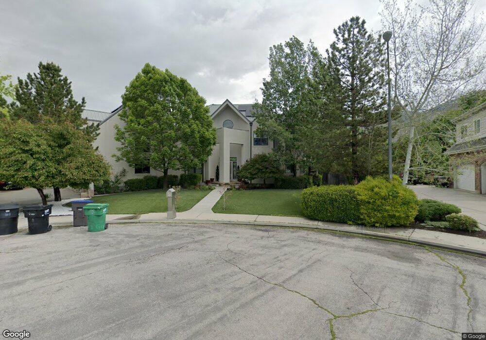
4102 N 190 W Provo, UT 84604
Riverside NeighborhoodEstimated Value: $2,181,000 - $2,382,000
5
Beds
6
Baths
5,687
Sq Ft
$398/Sq Ft
Est. Value
About This Home
This home is located at 4102 N 190 W, Provo, UT 84604 and is currently estimated at $2,261,495, approximately $397 per square foot. 4102 N 190 W is a home located in Utah County with nearby schools including Canyon Crest Elementary School, Centennial Middle School, and Timpview High School.
Ownership History
Date
Name
Owned For
Owner Type
Purchase Details
Closed on
Nov 29, 2023
Sold by
Johnson Curtis C
Bought by
C And T Johnson Family Trust and Johnson
Current Estimated Value
Purchase Details
Closed on
Apr 30, 2010
Sold by
Johnson Tamara and Johnson Curtis B
Bought by
Johnson Curtis C
Home Financials for this Owner
Home Financials are based on the most recent Mortgage that was taken out on this home.
Original Mortgage
$127,000
Interest Rate
5.04%
Mortgage Type
Credit Line Revolving
Purchase Details
Closed on
Aug 10, 2005
Sold by
Johnson Curtis C and Johnson Tamara B
Bought by
Johnson Tamara and Johnson Curtis B
Create a Home Valuation Report for This Property
The Home Valuation Report is an in-depth analysis detailing your home's value as well as a comparison with similar homes in the area
Home Values in the Area
Average Home Value in this Area
Purchase History
| Date | Buyer | Sale Price | Title Company |
|---|---|---|---|
| C And T Johnson Family Trust | -- | None Listed On Document | |
| Johnson Curtis C | -- | Provo Land Title Company | |
| Johnson Tamara | -- | -- |
Source: Public Records
Mortgage History
| Date | Status | Borrower | Loan Amount |
|---|---|---|---|
| Previous Owner | Johnson Curtis C | $127,000 | |
| Previous Owner | Johnson Curtis C | $417,000 |
Source: Public Records
Tax History Compared to Growth
Tax History
| Year | Tax Paid | Tax Assessment Tax Assessment Total Assessment is a certain percentage of the fair market value that is determined by local assessors to be the total taxable value of land and additions on the property. | Land | Improvement |
|---|---|---|---|---|
| 2025 | $9,595 | $1,015,245 | $660,000 | $1,185,900 |
| 2024 | $9,595 | $944,515 | $0 | $0 |
| 2023 | $9,535 | $925,320 | $0 | $0 |
| 2022 | $9,752 | $954,250 | $0 | $0 |
| 2021 | $7,895 | $1,347,400 | $515,500 | $831,900 |
| 2020 | $7,834 | $1,253,300 | $429,600 | $823,700 |
| 2019 | $6,724 | $1,118,700 | $429,600 | $689,100 |
| 2018 | $6,375 | $1,075,700 | $386,600 | $689,100 |
| 2017 | $6,381 | $591,635 | $0 | $0 |
| 2016 | $6,628 | $572,825 | $0 | $0 |
| 2015 | $6,233 | $544,500 | $0 | $0 |
| 2014 | $5,429 | $494,340 | $0 | $0 |
Source: Public Records
Map
Nearby Homes
- 282 W 4020 N
- 4246 N Stonecrossing
- 455 W 4150 St N
- 404 W 3700 N
- 299 E 4000 N
- 4161 N Canyon Rd Unit 2
- 3535 N 160 St W
- 387 S 1000 E
- 325 S 1000 E
- 645 Foothill Dr
- 3477 Brookside Dr
- 3711 N Canyon Rd
- 3430 Brookside Dr
- 1070 E 120 S
- 153 S 1000 E
- 350 S 900 E
- 209 E 4735 N
- 221 E 4735 N
- 1643 Mountain Oaks Dr
- 847 E 400 S
- 4118 N 190 W
- 4115 N 190 W
- 4075 N Edgewood Dr
- 4119 Edgewood Dr
- 4082 N Cove Dr
- 4082 N Cove Dr Unit 4
- 192 W 4130 N
- 4112 N Cove Dr
- 4105 N Edgewood Dr
- 4105 Edgewood Dr
- 4050 N Cove Dr
- 206 W 4130 N
- 4028 N Cove Dr
- 126 W 3960 N
- 4004 N Cove Dr
- 141 Stone Brook Ln
- 141 Stone Brook Ln Unit 25
- 4154 N Cove Dr
- 4045 Edgewood Dr
- 4062 Edgewood Dr