Estimated Value: $275,000 - $389,000
3
Beds
2
Baths
1,881
Sq Ft
$175/Sq Ft
Est. Value
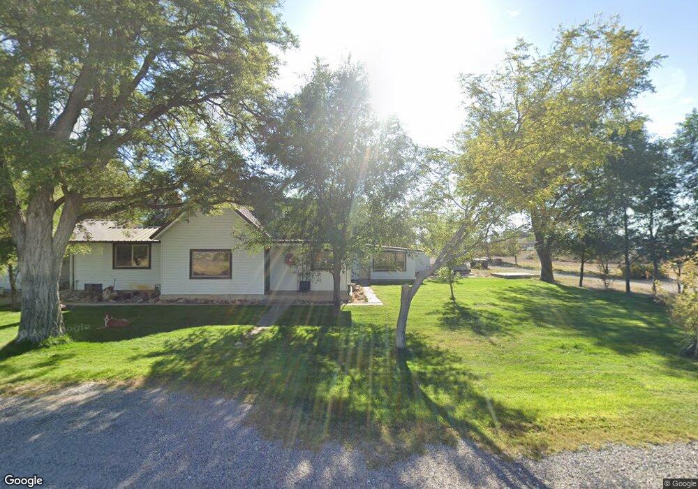
About This Home
This home is located at 4105 S 2750 W, Oasis, UT 84624 and is currently estimated at $328,525, approximately $174 per square foot. 4105 S 2750 W is a home located in Millard County.
Ownership History
Date
Name
Owned For
Owner Type
Purchase Details
Closed on
Apr 24, 2020
Sold by
Moody Brock R and Moody Danielle F
Bought by
Moody Brock and Moody Danielle
Current Estimated Value
Purchase Details
Closed on
Apr 20, 2011
Sold by
Memmott Vincent
Bought by
Moody Brock Rod and Moody Danielle F
Home Financials for this Owner
Home Financials are based on the most recent Mortgage that was taken out on this home.
Original Mortgage
$107,211
Outstanding Balance
$73,942
Interest Rate
4.87%
Mortgage Type
FHA
Estimated Equity
$254,583
Purchase Details
Closed on
Mar 9, 2007
Sold by
Memmott Berdell
Bought by
Memmott Berdell J
Create a Home Valuation Report for This Property
The Home Valuation Report is an in-depth analysis detailing your home's value as well as a comparison with similar homes in the area
Home Values in the Area
Average Home Value in this Area
Purchase History
| Date | Buyer | Sale Price | Title Company |
|---|---|---|---|
| Moody Brock | -- | None Available | |
| Moody Brock Rod | -- | -- | |
| Moody Brock Rod | -- | -- | |
| Memmott Berdell J | -- | -- |
Source: Public Records
Mortgage History
| Date | Status | Borrower | Loan Amount |
|---|---|---|---|
| Open | Moody Brock Rod | $107,211 | |
| Closed | Moody Brock Rod | $107,211 |
Source: Public Records
Tax History Compared to Growth
Tax History
| Year | Tax Paid | Tax Assessment Tax Assessment Total Assessment is a certain percentage of the fair market value that is determined by local assessors to be the total taxable value of land and additions on the property. | Land | Improvement |
|---|---|---|---|---|
| 2025 | $1,304 | $160,507 | $20,180 | $140,327 |
| 2024 | $1,304 | $149,718 | $16,142 | $133,576 |
| 2023 | $1,465 | $149,718 | $16,142 | $133,576 |
| 2022 | $1,183 | $104,733 | $15,130 | $89,603 |
| 2021 | $933 | $79,684 | $13,480 | $66,204 |
| 2020 | $1,092 | $93,970 | $29,764 | $64,206 |
| 2019 | $1,033 | $89,689 | $29,764 | $59,925 |
| 2018 | $928 | $82,639 | $29,764 | $52,875 |
| 2017 | $827 | $70,371 | $22,339 | $48,032 |
| 2016 | $790 | $70,371 | $22,339 | $48,032 |
| 2015 | $789 | $70,371 | $22,339 | $48,032 |
| 2014 | -- | $70,371 | $22,339 | $48,032 |
| 2013 | -- | $60,505 | $22,339 | $38,166 |
Source: Public Records
Map
Nearby Homes
- 470 S 2750 W Unit 6
- 460 S 2750 W Unit 7
- 490 S 2750 W Unit 5
- 465 S 2750 W Unit 4
- 6500 S 3000 West Rd
- 6177 S 3000 Rd W
- 0 Tbd 3000 Rd S Unit LotWP001
- 3885 W 4500 S
- 3770 S 4000 Rd W
- 3480 S 4000 W
- 17000 W 2500 Rd S
- 16700 W 2500 South Rd
- 16800 W 2500 South Rd
- 6500 W 2000 S
- 8000 S Highway 257
- 168 N 100 Rd W
- 289 W Center St S
- 1040 W Center St
- 700 Acres
- 1500 S 10000 W