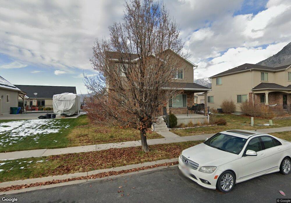
4106 W Hayes Cir Cedar Hills, UT 84062
Estimated Value: $579,000 - $620,000
5
Beds
4
Baths
2,562
Sq Ft
$231/Sq Ft
Est. Value
About This Home
This home is located at 4106 W Hayes Cir, Cedar Hills, UT 84062 and is currently estimated at $591,334, approximately $230 per square foot. 4106 W Hayes Cir is a home located in Utah County with nearby schools including Cedar Ridge Elementary School, Mountain Ridge Junior High School, and Lone Peak High School.
Ownership History
Date
Name
Owned For
Owner Type
Purchase Details
Closed on
Nov 5, 2021
Sold by
Colby Evans and Evans Brittany
Bought by
Reed Andrew L
Current Estimated Value
Home Financials for this Owner
Home Financials are based on the most recent Mortgage that was taken out on this home.
Original Mortgage
$414,400
Outstanding Balance
$379,142
Interest Rate
2.88%
Mortgage Type
New Conventional
Estimated Equity
$212,192
Purchase Details
Closed on
Nov 9, 2016
Sold by
Goldstiin Tawine K and Goldstiin Kyle A
Bought by
Evans Colby and Evans Brittanuy
Home Financials for this Owner
Home Financials are based on the most recent Mortgage that was taken out on this home.
Original Mortgage
$272,964
Interest Rate
3.37%
Mortgage Type
FHA
Purchase Details
Closed on
Aug 21, 2014
Sold by
Goldstein Kyle and Goldstein Tawnie
Bought by
Goldstein Tawnie K and Goldstein Kyle A
Home Financials for this Owner
Home Financials are based on the most recent Mortgage that was taken out on this home.
Original Mortgage
$208,000
Interest Rate
4.12%
Mortgage Type
New Conventional
Purchase Details
Closed on
Feb 16, 2012
Sold by
Dorado Investments Two Llc
Bought by
Goldstein Kyle and Gillespie Tawnie
Home Financials for this Owner
Home Financials are based on the most recent Mortgage that was taken out on this home.
Original Mortgage
$189,861
Interest Rate
3.87%
Mortgage Type
FHA
Purchase Details
Closed on
Dec 12, 2011
Sold by
Bronson Mary L
Bought by
Dorado Investments Two Llc
Purchase Details
Closed on
Sep 22, 2004
Sold by
Harris Brett Kenneth and Harris Heather Leigh
Bought by
Bronson Mary L
Home Financials for this Owner
Home Financials are based on the most recent Mortgage that was taken out on this home.
Original Mortgage
$159,310
Interest Rate
5.8%
Mortgage Type
Purchase Money Mortgage
Purchase Details
Closed on
May 13, 2004
Sold by
Cedars Point Llc
Bought by
Harris Brett Kenneth and Harris Heather Leigh
Home Financials for this Owner
Home Financials are based on the most recent Mortgage that was taken out on this home.
Original Mortgage
$157,600
Interest Rate
5.5%
Mortgage Type
Construction
Create a Home Valuation Report for This Property
The Home Valuation Report is an in-depth analysis detailing your home's value as well as a comparison with similar homes in the area
Home Values in the Area
Average Home Value in this Area
Purchase History
| Date | Buyer | Sale Price | Title Company |
|---|---|---|---|
| Reed Andrew L | -- | Us Title | |
| Evans Colby | -- | Eagle Gate Title Ins Agency | |
| Goldstein Tawnie K | -- | First American Title Co Llc | |
| Goldstein Kyle | -- | Select Title Insurance Agenc | |
| Dorado Investments Two Llc | -- | Accommodation | |
| Bronson Mary L | -- | Affiliated First Title Comp | |
| Harris Brett Kenneth | -- | -- |
Source: Public Records
Mortgage History
| Date | Status | Borrower | Loan Amount |
|---|---|---|---|
| Open | Reed Andrew L | $414,400 | |
| Previous Owner | Evans Colby | $272,964 | |
| Previous Owner | Goldstein Tawnie K | $208,000 | |
| Previous Owner | Goldstein Kyle | $189,861 | |
| Previous Owner | Bronson Mary L | $159,310 | |
| Previous Owner | Harris Brett Kenneth | $157,600 |
Source: Public Records
Tax History Compared to Growth
Tax History
| Year | Tax Paid | Tax Assessment Tax Assessment Total Assessment is a certain percentage of the fair market value that is determined by local assessors to be the total taxable value of land and additions on the property. | Land | Improvement |
|---|---|---|---|---|
| 2025 | $2,223 | $290,345 | $196,000 | $331,900 |
| 2024 | $2,223 | $263,285 | $0 | $0 |
| 2023 | $2,081 | $264,770 | $0 | $0 |
| 2022 | $2,219 | $275,825 | $0 | $0 |
| 2021 | $1,995 | $369,400 | $118,900 | $250,500 |
| 2020 | $1,859 | $335,800 | $110,100 | $225,700 |
| 2019 | $1,670 | $313,300 | $110,100 | $203,200 |
| 2018 | $1,586 | $280,400 | $103,700 | $176,700 |
| 2017 | $1,575 | $148,830 | $0 | $0 |
| 2016 | $1,529 | $134,365 | $0 | $0 |
| 2015 | $1,444 | $120,120 | $0 | $0 |
| 2014 | $1,302 | $107,580 | $0 | $0 |
Source: Public Records
Map
Nearby Homes
- 4084 W Shinnecock
- 10587 N Avalon St
- 10795 N La Costa
- 10514 N Doral Dr
- 4292 W Joshua Ln
- 10412 N Bayhill Dr
- 10456 N Morgan Blvd
- 11197 N Park Dr
- 10468 N Sage Vista Ln
- 10448 Sage Vista Ln
- 10207 N Cottonwood Dr
- 4198 W Sage Rd N
- 10535 Janie Ln
- 4616 W Carriage Ln
- 3870 Mountaintop Cir
- 1263 E Chapman Ct
- 3851 W Mountaintop Cir Unit 5
- 9900 N Meadow Dr
- 1292 E 810 S
- 10052 N Marigold Ln
- 4098 Hayes Cir
- 4114 W Hayes Cir
- 4092 W Hayes Cir
- 4092 W Hayes Cir
- 10746 N Sheridan Unit 4150
- 10738 Congressional
- 4099 Shinnecock
- 4099 W Shinnecock
- 4086 W Hayes Cir
- 4122 W Hayes Cir
- 4086 W Hayes Cir
- 10732 N Congressional
- 4122 W Medinah
- 4122 Medinah
- 4121 W Medinah
- 10754 Sheridan Unit 4150
- 10754 N Sheridan
- 4091 Shinnecock
- 4091 Shinnecock Unit 23 C
- 4078 Hayes Cir