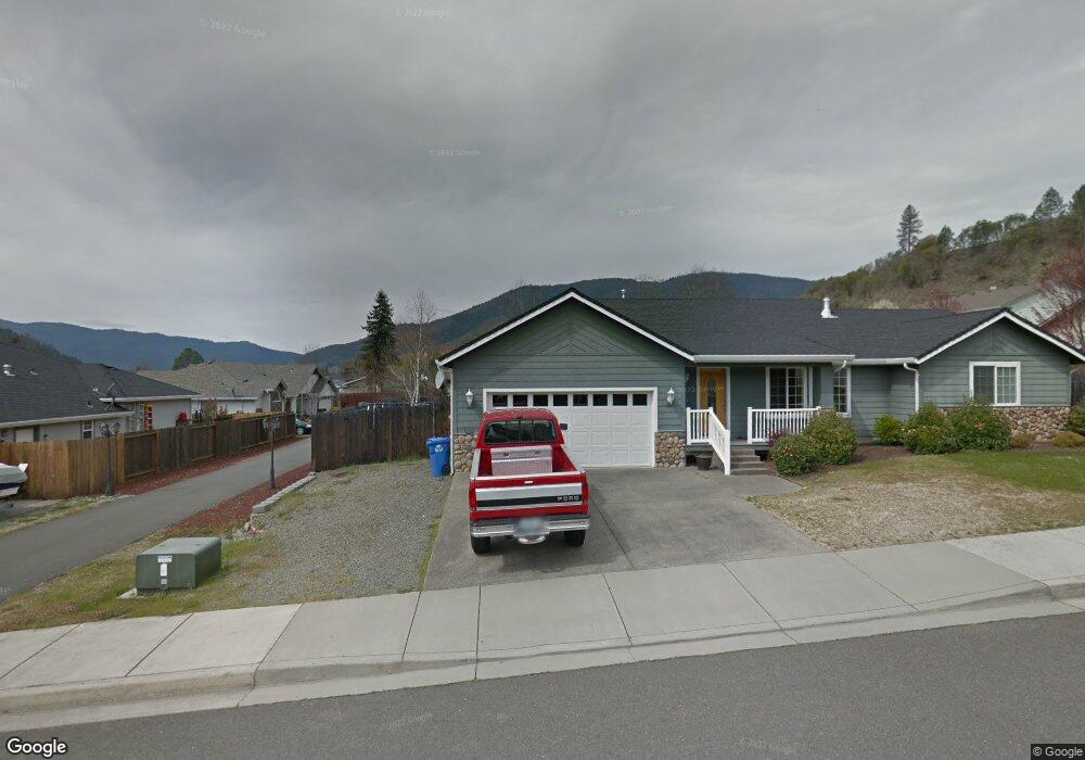
411 Cypress Ave Rogue River, OR 97537
Estimated Value: $470,000 - $486,850
3
Beds
2
Baths
1,704
Sq Ft
$280/Sq Ft
Est. Value
About This Home
This home is located at 411 Cypress Ave, Rogue River, OR 97537 and is currently estimated at $477,463, approximately $280 per square foot. 411 Cypress Ave is a home located in Jackson County with nearby schools including Rogue River Elementary School, South Valley Academy, and Rogue River Junior/Senior High School.
Ownership History
Date
Name
Owned For
Owner Type
Purchase Details
Closed on
May 22, 2007
Sold by
Dean Douglas G and Dean Rebecca
Bought by
Dean Douglas G and Dean Rebecca
Current Estimated Value
Purchase Details
Closed on
Dec 24, 2001
Sold by
Switzer Joann and The Joann Switzer Family Trust
Bought by
Dean Douglas G and Dean Rebecca
Home Financials for this Owner
Home Financials are based on the most recent Mortgage that was taken out on this home.
Original Mortgage
$148,300
Interest Rate
6.8%
Create a Home Valuation Report for This Property
The Home Valuation Report is an in-depth analysis detailing your home's value as well as a comparison with similar homes in the area
Home Values in the Area
Average Home Value in this Area
Purchase History
| Date | Buyer | Sale Price | Title Company |
|---|---|---|---|
| Dean Douglas G | -- | None Available | |
| Dean Douglas G | $52,000 | Amerititle Inc |
Source: Public Records
Mortgage History
| Date | Status | Borrower | Loan Amount |
|---|---|---|---|
| Previous Owner | Dean Douglas G | $148,300 |
Source: Public Records
Tax History Compared to Growth
Tax History
| Year | Tax Paid | Tax Assessment Tax Assessment Total Assessment is a certain percentage of the fair market value that is determined by local assessors to be the total taxable value of land and additions on the property. | Land | Improvement |
|---|---|---|---|---|
| 2025 | $3,790 | $265,410 | $99,050 | $166,360 |
| 2024 | $3,790 | $257,680 | $96,160 | $161,520 |
| 2023 | $3,667 | $250,180 | $93,360 | $156,820 |
| 2022 | $3,581 | $250,180 | $93,360 | $156,820 |
| 2021 | $3,546 | $242,900 | $90,640 | $152,260 |
| 2020 | $3,457 | $235,830 | $88,000 | $147,830 |
| 2019 | $3,375 | $222,310 | $82,950 | $139,360 |
| 2018 | $3,288 | $215,840 | $80,540 | $135,300 |
| 2017 | $3,215 | $215,840 | $80,540 | $135,300 |
| 2016 | $3,136 | $203,460 | $75,910 | $127,550 |
| 2015 | $3,050 | $203,460 | $71,250 | $132,210 |
| 2014 | $2,954 | $191,790 | $67,160 | $124,630 |
Source: Public Records
Map
Nearby Homes
- 105 Brolin Ct
- 305 Woodville Way
- 300 Woodville Way
- 904 Broadway St Unit 503
- 182 Wards Creek Rd
- 2661 Wards Creek Rd
- 0 Oak St
- 419 E Main St
- 111 Cedar St
- TL 1303 E Main St
- 405 Magerle Ln
- 5525 Red Tail Ln
- 5500 Red Tail Ln
- 202 Arbor St
- 207 Madrone St
- 815 Pine St Unit 10
- 208 W Main St
- 4529 E Evans Creek Rd
- 299 Foothill Blvd
- 0 W Evans Creek Rd Unit 1000 220202360