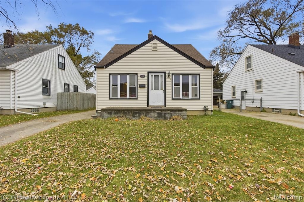
411 N Stephenson Hwy Royal Oak, MI 48067
Estimated payment $1,154/month
Highlights
- Ground Level Unit
- No HOA
- Bungalow
- Royal Oak High School Rated 9+
- 2 Car Detached Garage
- Heating system powered by renewable energy
About This Home
*Motivated Seller.* If you’re looking for a home with instant equity after a little TLC, a property in the beautiful city of Royal Oak, or your next rental to add to your portfolio, this opportunity checks every box. This three bedroom, one bathroom bungalow offers strong bones, a brand new roof already taken care of, and the chance to bring your own updates to the kitchen and throughout the home. With a few improvements, this becomes a valuable asset in an amazing location, ready for a homeowner, investor, or anyone looking for a smart buy.
Home Details
Home Type
- Single Family
Est. Annual Taxes
Year Built
- Built in 1949
Lot Details
- 4,356 Sq Ft Lot
- Lot Dimensions are 42x105
Parking
- 2 Car Detached Garage
Home Design
- Bungalow
- Block Foundation
- Vinyl Construction Material
Interior Spaces
- 980 Sq Ft Home
- 2-Story Property
- Unfinished Basement
Bedrooms and Bathrooms
- 3 Bedrooms
- 1 Full Bathroom
Location
- Ground Level Unit
Utilities
- Heating system powered by renewable energy
- Heating System Uses Natural Gas
Community Details
- No Home Owners Association
- Stephenson Super Highwayno 6 Royal Oak Subdivision
Listing and Financial Details
- Assessor Parcel Number 2514379018
Map
Home Values in the Area
Average Home Value in this Area
Tax History
| Year | Tax Paid | Tax Assessment Tax Assessment Total Assessment is a certain percentage of the fair market value that is determined by local assessors to be the total taxable value of land and additions on the property. | Land | Improvement |
|---|---|---|---|---|
| 2024 | $2,597 | $87,670 | $0 | $0 |
| 2022 | $3,151 | $77,590 | $0 | $0 |
| 2020 | $2,293 | $0 | $0 | $0 |
| 2018 | $3,151 | $60,120 | $0 | $0 |
| 2017 | $1,877 | $60,120 | $0 | $0 |
| 2015 | -- | $51,500 | $0 | $0 |
| 2014 | -- | $46,000 | $0 | $0 |
| 2011 | -- | $49,610 | $0 | $0 |
Property History
| Date | Event | Price | List to Sale | Price per Sq Ft |
|---|---|---|---|---|
| 11/24/2025 11/24/25 | Pending | -- | -- | -- |
| 11/20/2025 11/20/25 | For Sale | $164,900 | -- | $168 / Sq Ft |
Purchase History
| Date | Type | Sale Price | Title Company |
|---|---|---|---|
| Warranty Deed | $125,000 | None Available | |
| Interfamily Deed Transfer | -- | Oak Hills Land Title Agency | |
| Interfamily Deed Transfer | -- | None Available |
Mortgage History
| Date | Status | Loan Amount | Loan Type |
|---|---|---|---|
| Open | $100,000 | New Conventional |
Source: Realcomp
MLS Number: 20251055543
APN: 25-14-379-018
Disclaimer: Certain information contained herein is derived from information provided by parties other than Homes.com. All information provided is deemed reliable, but is not guaranteed to be accurate and should be independently verified.
![]() IDX provided courtesy of Realcomp II Ltd. via Ten-X and MLS
IDX provided courtesy of Realcomp II Ltd. via Ten-X and MLS
Copyright 2025 Realcomp II Ltd. Shareholders
IDX information is provided exclusively for consumers' personal, noncommercial use and may not be used for any purpose other than to identify prospective properties consumers may be interested in purchasing. The accuracy of all information, regardless of source, is not guaranteed or warranted. All information should be independently verified.
Listing Information presented by local MLS brokerage: Ten-X, local REALTOR®- Arlene Richardson - (888)-952-6393
- 415 N Stephenson Hwy
- 627 Symes Ave
- 940 Mace Ave
- 305 N Kenwood Ave
- 1809 Taylor Ave
- 122 S Edgeworth Ave
- 116 S Kenwood Ave
- 27699 Brettonwoods St
- 27042 Brettonwoods St
- 131 S Dorchester Ave
- 27840 Hampden St
- 27907 Lenox Ave
- 812 N Edison Ave
- 710 N Campbell Rd
- 629 N Campbell Rd
- 27700 Dartmouth St
- 1019 Symes Ct
- 622 N Wilson Ave
- 313 S Dorchester Ave
- 26584 Hampden St
