Estimated Value: $4,284,401 - $4,992,000
4
Beds
2
Baths
5,568
Sq Ft
$832/Sq Ft
Est. Value
About This Home
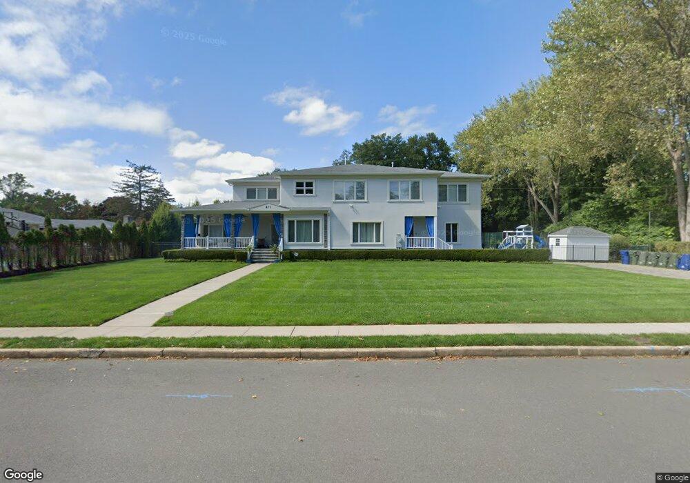
This home is located at 411 Sheridan Ave, Deal, NJ 07723 and is currently estimated at $4,633,467, approximately $832 per square foot. 411 Sheridan Ave is a home located in Monmouth County with nearby schools including Ocean Township High School, St. Mary of the Assumption School, and Ma'or Yeshiva High School for Boys.
Ownership History
Date
Name
Owned For
Owner Type
Purchase Details
Closed on
Jan 5, 1998
Sold by
Gadeloff Tsemah
Bought by
Khezrie Gabriel and Khezrie Joyce
Current Estimated Value
Create a Home Valuation Report for This Property
The Home Valuation Report is an in-depth analysis detailing your home's value as well as a comparison with similar homes in the area
Home Values in the Area
Average Home Value in this Area
Purchase History
| Date | Buyer | Sale Price | Title Company |
|---|---|---|---|
| Khezrie Gabriel | $425,000 | -- |
Source: Public Records
Tax History Compared to Growth
Tax History
| Year | Tax Paid | Tax Assessment Tax Assessment Total Assessment is a certain percentage of the fair market value that is determined by local assessors to be the total taxable value of land and additions on the property. | Land | Improvement |
|---|---|---|---|---|
| 2025 | $46,696 | $3,577,600 | $2,220,800 | $1,356,800 |
| 2024 | $41,084 | $3,274,600 | $2,020,800 | $1,253,800 |
| 2023 | $41,084 | $2,687,000 | $1,670,800 | $1,016,200 |
| 2022 | $38,819 | $2,559,700 | $1,593,200 | $966,500 |
| 2021 | $38,819 | $1,975,500 | $1,182,800 | $792,700 |
| 2020 | $33,526 | $1,683,900 | $955,200 | $728,700 |
| 2019 | $32,206 | $1,579,500 | $855,200 | $724,300 |
| 2018 | $32,139 | $1,534,800 | $795,200 | $739,600 |
| 2017 | $28,979 | $1,378,000 | $680,200 | $697,800 |
| 2016 | $29,398 | $1,257,400 | $602,500 | $654,900 |
| 2015 | $28,643 | $1,240,500 | $602,500 | $638,000 |
| 2014 | $29,238 | $1,283,500 | $602,500 | $681,000 |
Source: Public Records
Map
Nearby Homes
- 460 Runyan Ave
- 1 Country Club Dr
- 408 Crosby Ave
- 504 Crosby Ave
- 404 Brookside Ave
- 10 Campbell Ct
- 103 Poplar Ave
- 116 Phillips Ave
- 306 Roosevelt Ave
- 221 Elmwood Rd
- 0 Overbrook Ave
- 243 Woodcrest Rd
- 210 Larchwood Ave
- 240 Highwood Rd
- 296 Garfield Ave
- 267 Roosevelt Ave
- 328 Elberon Blvd
- 408 Deal Rd
- 35 Shadow Lawn Dr
- 227 Chatham Ave
- 400 Parker Ave
- 414 Parker Ave
- 410 Sheridan Ave
- 325 Sherman Ave
- 418 Parker Ave
- 425 Golf Rd
- 401 Parker Ave
- 402 Sherman Ave
- 415 Parker Ave
- 326 Sherman Ave
- 326 Sherman Ave Unit WINTER
- 406 Sherman Ave
- 308 Parker Ave
- 305 Parker Ave
- 425 Sherman Ave
- 410 Sherman Ave
- 424 Parker Ave
- 419 Parker Ave
- 303 Parker Ave
- 322 Sheridan Ave