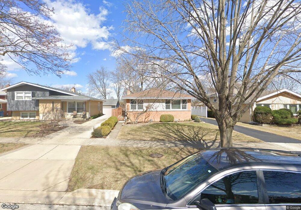
411 W Commonwealth Ln Elmhurst, IL 60126
Estimated Value: $370,457 - $480,000
Studio
--
Bath
1,296
Sq Ft
$340/Sq Ft
Est. Value
About This Home
This home is located at 411 W Commonwealth Ln, Elmhurst, IL 60126 and is currently estimated at $440,864, approximately $340 per square foot. 411 W Commonwealth Ln is a home located in DuPage County with nearby schools including Salt Creek Elementary School, Stella May Swartz Elementary School, and John E Albright Middle School.
Ownership History
Date
Name
Owned For
Owner Type
Purchase Details
Closed on
Aug 21, 1998
Sold by
Tarvid Mitchell J
Bought by
Tarvid Mitchell J and Tarvid Margaret M
Current Estimated Value
Purchase Details
Closed on
Aug 17, 1995
Sold by
Americanmidwest Bank & Trust
Bought by
Tarvid Mitchell J
Home Financials for this Owner
Home Financials are based on the most recent Mortgage that was taken out on this home.
Original Mortgage
$100,000
Interest Rate
7.43%
Create a Home Valuation Report for This Property
The Home Valuation Report is an in-depth analysis detailing your home's value as well as a comparison with similar homes in the area
Home Values in the Area
Average Home Value in this Area
Purchase History
| Date | Buyer | Sale Price | Title Company |
|---|---|---|---|
| Tarvid Mitchell J | -- | -- | |
| Tarvid Mitchell J | $190,000 | -- |
Source: Public Records
Mortgage History
| Date | Status | Borrower | Loan Amount |
|---|---|---|---|
| Closed | Tarvid Mitchell J | $100,000 |
Source: Public Records
Tax History
| Year | Tax Paid | Tax Assessment Tax Assessment Total Assessment is a certain percentage of the fair market value that is determined by local assessors to be the total taxable value of land and additions on the property. | Land | Improvement |
|---|---|---|---|---|
| 2024 | $5,797 | $123,118 | $31,480 | $91,638 |
| 2023 | $5,341 | $113,850 | $29,110 | $84,740 |
| 2022 | $5,135 | $109,460 | $28,000 | $81,460 |
| 2021 | $5,223 | $106,730 | $27,300 | $79,430 |
| 2020 | $5,166 | $104,390 | $26,700 | $77,690 |
| 2019 | $4,962 | $99,240 | $25,380 | $73,860 |
| 2018 | $4,869 | $95,090 | $24,030 | $71,060 |
| 2017 | $4,791 | $90,610 | $22,900 | $67,710 |
| 2016 | $4,509 | $85,360 | $21,570 | $63,790 |
| 2015 | $4,439 | $79,520 | $20,090 | $59,430 |
| 2014 | $4,583 | $78,370 | $18,340 | $60,030 |
| 2013 | $4,537 | $79,480 | $18,600 | $60,880 |
Source: Public Records
Map
Nearby Homes
- 465 W Verret St
- 964 S Hillside Ave
- 8 Saint Regis Ct
- 3 Charlotte Cir
- 3 Dewalt Ct
- 2 S Atrium Way Unit 606
- 995 S Swain Ave
- 1S045 Spring Rd Unit H2
- 1S045 Spring Rd Unit 1D
- 1S055 Spring Rd Unit 1C
- 20 Oak Tree Ct
- 1 Maple Tree Ct
- 868 S Spring Rd
- 936 S Mitchell Ave
- 625 E Van Buren St
- 1200 S Prospect Ave Unit 108
- 4 Oak Brook Club Dr Unit G205
- 130 Crab Apple Ln
- 1335 S Villa Ave
- 1 Oak Brook Club Dr Unit A310
- 407 W Commonwealth Ln
- 415 W Commonwealth Ln
- 419 W Commonwealth Ln
- 403 W Commonwealth Ln
- 423 W Commonwealth Ln
- 399 W Commonwealth Ln
- 408 W Commonwealth Ln
- 395 W Commonwealth Ln
- 416 W Commonwealth Ln
- 412 W Commonwealth Ln
- 420 W Commonwealth Ln
- 402 W Commonwealth Ln
- 431 W Commonwealth Ln
- 424 W Commonwealth Ln
- 391 W Commonwealth Ln
- 428 W Commonwealth Ln
- 435 W Commonwealth Ln
- 400 W Commonwealth Ln
- 432 W Commonwealth Ln
- 396 W Commonwealth Ln
Your Personal Tour Guide
Ask me questions while you tour the home.