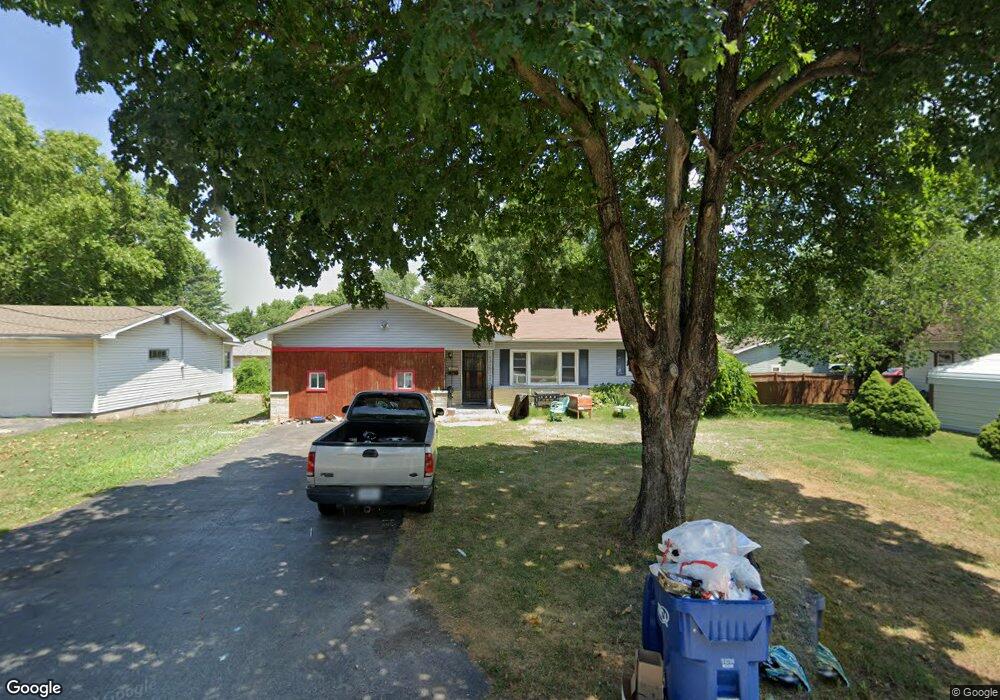
411 W Grant St Republic, MO 65738
Estimated Value: $203,000 - $228,000
3
Beds
2
Baths
1,372
Sq Ft
$155/Sq Ft
Est. Value
About This Home
This home is located at 411 W Grant St, Republic, MO 65738 and is currently estimated at $212,726, approximately $155 per square foot. 411 W Grant St is a home located in Greene County with nearby schools including Schofield Elementary School, Republic Middle School, and Republic High School.
Ownership History
Date
Name
Owned For
Owner Type
Purchase Details
Closed on
Sep 12, 2025
Sold by
Springfield Property Solutions Llc
Bought by
Fresh Start Real Estate Services Llc
Current Estimated Value
Purchase Details
Closed on
Jun 23, 2011
Sold by
Sneed Peggy Ivon and Oswalt Linda Faye
Bought by
Blankenship William Shane and Blankenship Sarah E
Home Financials for this Owner
Home Financials are based on the most recent Mortgage that was taken out on this home.
Original Mortgage
$82,800
Interest Rate
4.7%
Mortgage Type
New Conventional
Create a Home Valuation Report for This Property
The Home Valuation Report is an in-depth analysis detailing your home's value as well as a comparison with similar homes in the area
Home Values in the Area
Average Home Value in this Area
Purchase History
| Date | Buyer | Sale Price | Title Company |
|---|---|---|---|
| Fresh Start Real Estate Services Llc | -- | None Listed On Document | |
| Springfield Property Solutions Llc | -- | None Listed On Document | |
| Blankenship William Shane | -- | Lincoln Land Title Inc |
Source: Public Records
Mortgage History
| Date | Status | Borrower | Loan Amount |
|---|---|---|---|
| Previous Owner | Blankenship William Shane | $82,800 |
Source: Public Records
Tax History
| Year | Tax Paid | Tax Assessment Tax Assessment Total Assessment is a certain percentage of the fair market value that is determined by local assessors to be the total taxable value of land and additions on the property. | Land | Improvement |
|---|---|---|---|---|
| 2025 | $1,028 | $19,360 | $5,700 | $13,660 |
| 2024 | $964 | $17,250 | $4,750 | $12,500 |
| 2023 | $945 | $17,250 | $4,750 | $12,500 |
| 2022 | $878 | $15,940 | $4,750 | $11,190 |
| 2021 | $872 | $15,940 | $4,750 | $11,190 |
| 2020 | $809 | $14,550 | $4,750 | $9,800 |
| 2019 | $806 | $14,550 | $4,750 | $9,800 |
| 2018 | $761 | $13,280 | $3,800 | $9,480 |
| 2017 | $755 | $12,540 | $3,800 | $8,740 |
| 2016 | $721 | $12,540 | $3,800 | $8,740 |
| 2015 | $718 | $12,540 | $3,800 | $8,740 |
| 2014 | $722 | $12,500 | $3,800 | $8,700 |
Source: Public Records
Map
Nearby Homes
- 421 W Elm St
- 413 W Elm St
- 347 W Elm St
- 411 N College Ave
- 114 S Eagan St
- 393 N Ladera Dr
- 319 W Hines St
- 626 N Phelps Ave
- 548 S Buxton Ln
- 566 S Buxton Ln
- 401 S West Ave
- 1213 N London Place
- 0 Highway 60 Unit 60308100
- 0 Highway 60 Unit 60308095
- 511 S Main Ave
- 425 E Harrison St
- 2450 Highway 60
- 609 S Mckee Ave
- 000 W Crestview Ln
- 1001 W Broad St
- 417 W Grant St
- 203 N West Ave
- 211 N West Ave
- 412 W Olive St
- 414 W Olive St
- 425 W Grant St
- 406 W Olive St
- 145 N West Ave
- 414 W Grant St
- 416 W Olive St
- 348 W Olive St
- 422 W Grant St
- 418 W Olive St
- 431 W Grant St
- 344 W Olive St
- 303 N West Ave
- 407 W Harrison St
- 417 W Olive St
- 341 W Grant St
- 139 N West Ave
Your Personal Tour Guide
Ask me questions while you tour the home.