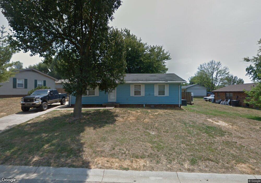
4112 Michael Dr Henderson, KY 42420
Estimated Value: $86,000 - $171,000
3
Beds
2
Baths
1,196
Sq Ft
$121/Sq Ft
Est. Value
About This Home
This home is located at 4112 Michael Dr, Henderson, KY 42420 and is currently estimated at $144,174, approximately $120 per square foot. 4112 Michael Dr is a home located in Henderson County with nearby schools including Spottsville Elementary School, Henderson County North Middle School, and Henderson County High School.
Ownership History
Date
Name
Owned For
Owner Type
Purchase Details
Closed on
Oct 30, 2023
Sold by
D & L Properties East Llc
Bought by
Hogge Emily
Current Estimated Value
Purchase Details
Closed on
Aug 16, 2011
Sold by
Haygan Stanley L
Bought by
Duncan Buron A
Home Financials for this Owner
Home Financials are based on the most recent Mortgage that was taken out on this home.
Original Mortgage
$73,098
Interest Rate
4.37%
Mortgage Type
FHA
Create a Home Valuation Report for This Property
The Home Valuation Report is an in-depth analysis detailing your home's value as well as a comparison with similar homes in the area
Home Values in the Area
Average Home Value in this Area
Purchase History
| Date | Buyer | Sale Price | Title Company |
|---|---|---|---|
| Hogge Emily | $79,700 | None Listed On Document | |
| Duncan Buron A | $75,000 | None Available |
Source: Public Records
Mortgage History
| Date | Status | Borrower | Loan Amount |
|---|---|---|---|
| Previous Owner | Duncan Buron A | $73,098 |
Source: Public Records
Tax History Compared to Growth
Tax History
| Year | Tax Paid | Tax Assessment Tax Assessment Total Assessment is a certain percentage of the fair market value that is determined by local assessors to be the total taxable value of land and additions on the property. | Land | Improvement |
|---|---|---|---|---|
| 2024 | $1,028 | $88,000 | $0 | $0 |
| 2023 | $1,039 | $88,000 | $0 | $0 |
| 2022 | $941 | $80,000 | $0 | $0 |
| 2021 | $94 | $80,000 | $0 | $0 |
| 2020 | $922 | $80,000 | $0 | $0 |
| 2019 | $906 | $75,000 | $0 | $0 |
| 2018 | $854 | $75,000 | $0 | $0 |
| 2017 | $836 | $75,000 | $0 | $0 |
| 2016 | $740 | $75,000 | $0 | $0 |
| 2014 | $680 | $75,000 | $15,000 | $60,000 |
Source: Public Records
Map
Nearby Homes
- 1036 Ernest Ln
- 5462 US Highway 60 E
- 7895 Westbury Ct
- 7394 Rucker Road 1 E
- 7880 Westbury Ct
- 932 Millcreek Dr
- 3100 Copper Creek Dr
- 3034 Copper Creek Dr Unit Drive
- 3038 Copper Creek Dr Unit Drive
- 2433 Cobblestone Dr
- 3017 Copper Creek Dr Unit Drive
- 3019 Copper Creek Dr Unit Drive
- 3043 Copper Creek Dr Unit Drive
- 961 Osage Dr
- 1320 Glenshiel Dr
- 2931 Northridge Path
- 837 Morningside Dr
- 1300 Alastair Dr
- 1220 Glenshiel Dr
- 253 S Bentley Dr
- 4118 Michael Dr
- 3527 Henrys Way
- 3533 Henrys Way
- 4124 Michael Dr
- 4111 Michael Dr
- 3518 Susans Ct
- 4115 Michael Dr
- 3537 Henrys Way
- 3517 Henrys Way
- 4121 Michael Dr
- 3526 Henrys Way
- 3530 Henrys Way
- 3532 Judith Ann Dr
- 3526 Henry's Way
- 4125 Michael Dr
- 3522 Henrys Way
- 3534 Henrys Way
- 3541 Henrys Way
- 3512 Susans Ct
- 4131 Michael Dr