Estimated Value: $344,000 - $397,000
3
Beds
3
Baths
2,124
Sq Ft
$169/Sq Ft
Est. Value
About This Home
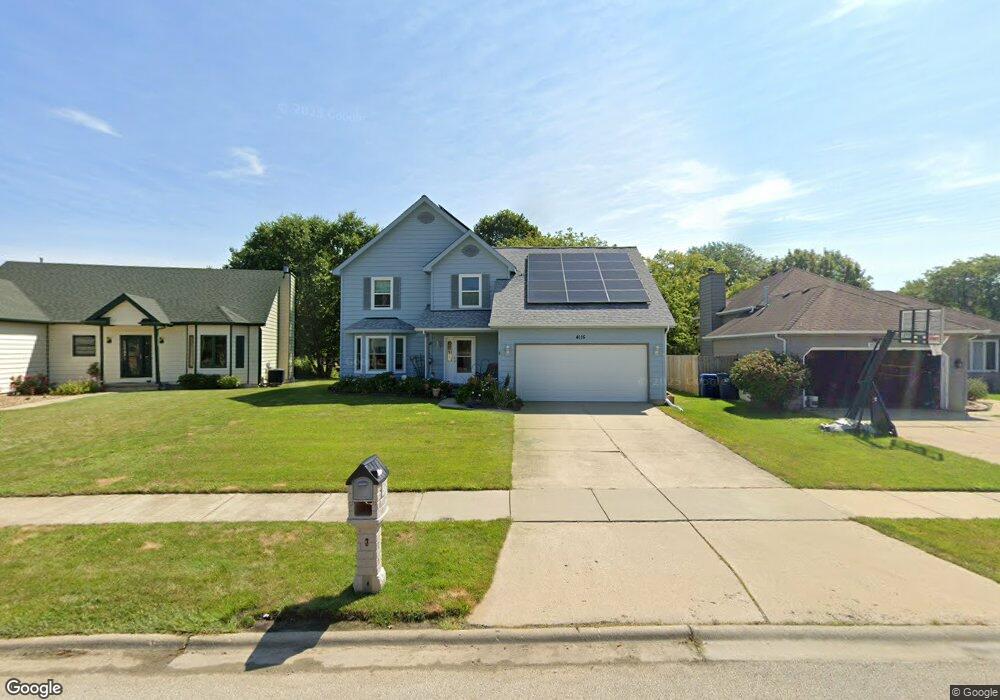
This home is located at 4115 Bertrand Ln, Zion, IL 60099 and is currently estimated at $358,336, approximately $168 per square foot. 4115 Bertrand Ln is a home located in Lake County with nearby schools including Howe Elementary School, Beach Park Middle School, and Zion-Benton Township High School.
Ownership History
Date
Name
Owned For
Owner Type
Purchase Details
Closed on
Mar 23, 2004
Sold by
Meier Daniel A and Meier Paula J
Bought by
Meier Daniel A and Meier Paula J
Current Estimated Value
Purchase Details
Closed on
Jan 22, 2001
Sold by
Larson Alvar
Bought by
Meier Daniel A and Meier Paula J
Home Financials for this Owner
Home Financials are based on the most recent Mortgage that was taken out on this home.
Original Mortgage
$150,000
Outstanding Balance
$53,898
Interest Rate
7.18%
Estimated Equity
$304,438
Create a Home Valuation Report for This Property
The Home Valuation Report is an in-depth analysis detailing your home's value as well as a comparison with similar homes in the area
Home Values in the Area
Average Home Value in this Area
Purchase History
| Date | Buyer | Sale Price | Title Company |
|---|---|---|---|
| Meier Daniel A | -- | -- | |
| Meier Daniel A | $202,000 | First American Title |
Source: Public Records
Mortgage History
| Date | Status | Borrower | Loan Amount |
|---|---|---|---|
| Open | Meier Daniel A | $150,000 |
Source: Public Records
Tax History Compared to Growth
Tax History
| Year | Tax Paid | Tax Assessment Tax Assessment Total Assessment is a certain percentage of the fair market value that is determined by local assessors to be the total taxable value of land and additions on the property. | Land | Improvement |
|---|---|---|---|---|
| 2024 | -- | $101,755 | $6,627 | $95,128 |
| 2023 | -- | $89,209 | $6,397 | $82,812 |
| 2022 | $0 | $80,687 | $6,258 | $74,429 |
| 2021 | $8,288 | $78,635 | $6,099 | $72,536 |
| 2020 | $8,288 | $75,040 | $5,820 | $69,220 |
| 2019 | $8,822 | $75,304 | $5,522 | $69,782 |
| 2018 | $7,689 | $63,065 | $6,662 | $56,403 |
| 2017 | $8,651 | $59,327 | $6,267 | $53,060 |
| 2016 | $8,905 | $59,202 | $5,966 | $53,236 |
| 2015 | $8,642 | $54,293 | $5,471 | $48,822 |
| 2014 | $10,159 | $65,505 | $14,344 | $51,161 |
| 2012 | $10,170 | $68,071 | $14,906 | $53,165 |
Source: Public Records
Map
Nearby Homes
- 10765 W Liberty Ave
- 1121 Otto Graham Ln
- 3931 Bertrand Ln
- 38571 N Cedar Ave
- 11345 W Carnahan Ave
- 11382 W Leland Ave
- 11342-11346 W Wadsworth Rd
- 38683 N Lewis Ave
- 1667 W Beach Rd Unit 1667
- 3225 Gilead Ave
- 3224 Gilboa Ave
- 1677 W Beach Rd Unit 1677
- 10295 W Crissy Ave
- 3221 Gideon Ave
- 1730 W Beach Rd
- 2614 33rd St
- 39161 N Holdridge Ave
- 10205 W Ames Ave
- 10209 W Crissy Ave
- 38176 N De Woody Rd
- 4119 Bertrand Ln
- 4109 Bertrand Ln
- 4123 Bertrand Ln
- 10852 W Pickford Ave
- 10853 W Fairbanks Ave
- 4116 Bertrand Ln
- 4105 Bertrand Ln
- 4127 Bertrand Ln
- 4112 Bertrand Ln
- 4120 Bertrand Ln
- 1112 Mary Jane Ln
- 4101 Bertrand Ln
- 1109 Bank Ln
- 1113 Bank Ln
- 10844 W Pickford Ave
- 1119 Leo Singer Ln
- 10853 W Pickford Ave
- 10839 W Fairbanks Ave
- 1123 Leo Singer Ln