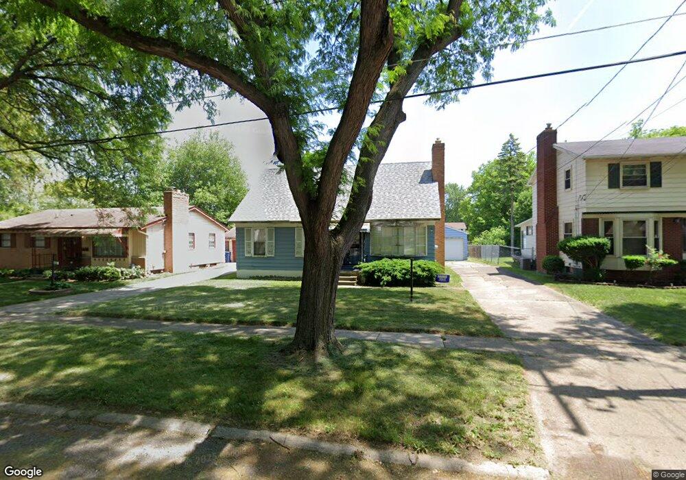
4116 Comstock Ave Flint, MI 48504
Merill NeighborhoodEstimated Value: $63,000 - $76,000
4
Beds
2
Baths
1,536
Sq Ft
$44/Sq Ft
Est. Value
About This Home
This home is located at 4116 Comstock Ave, Flint, MI 48504 and is currently estimated at $67,837, approximately $44 per square foot. 4116 Comstock Ave is a home located in Genesee County with nearby schools including Brownell STEM Academy, The New Standard Academy, and Eagle's Nest Academy.
Ownership History
Date
Name
Owned For
Owner Type
Purchase Details
Closed on
May 9, 2018
Sold by
Genesee County Land Bank Authority
Bought by
Woods Brandon
Current Estimated Value
Purchase Details
Closed on
Feb 23, 2016
Sold by
The Genesee County Land Bank Authority
Bought by
Woods Brandon
Purchase Details
Closed on
Dec 17, 2015
Sold by
Genesee County
Bought by
Genesee County Land Bank
Purchase Details
Closed on
Jun 25, 2001
Sold by
Mclawhorn Barredell and Mclawhorn Peggy A
Bought by
Woods Hurley F and Woods Beverly S
Home Financials for this Owner
Home Financials are based on the most recent Mortgage that was taken out on this home.
Original Mortgage
$71,100
Interest Rate
11.1%
Create a Home Valuation Report for This Property
The Home Valuation Report is an in-depth analysis detailing your home's value as well as a comparison with similar homes in the area
Home Values in the Area
Average Home Value in this Area
Purchase History
| Date | Buyer | Sale Price | Title Company |
|---|---|---|---|
| Woods Brandon | $3,000 | None Available | |
| Woods Brandon | $3,000 | None Available | |
| Genesee County Land Bank | -- | None Available | |
| Woods Hurley F | $78,000 | Lawyers Title Insurance Corp |
Source: Public Records
Mortgage History
| Date | Status | Borrower | Loan Amount |
|---|---|---|---|
| Previous Owner | Woods Hurley F | $71,100 | |
| Closed | Woods Brandon | $0 |
Source: Public Records
Tax History
| Year | Tax Paid | Tax Assessment Tax Assessment Total Assessment is a certain percentage of the fair market value that is determined by local assessors to be the total taxable value of land and additions on the property. | Land | Improvement |
|---|---|---|---|---|
| 2025 | $1,054 | $30,100 | $0 | $0 |
| 2024 | $952 | $25,300 | $0 | $0 |
| 2023 | $934 | $17,700 | $0 | $0 |
| 2022 | $0 | $13,500 | $0 | $0 |
| 2021 | $972 | $13,000 | $0 | $0 |
| 2020 | $905 | $14,500 | $0 | $0 |
| 2019 | $879 | $13,200 | $0 | $0 |
| 2018 | $1,012 | $15,800 | $0 | $0 |
| 2017 | $982 | $0 | $0 | $0 |
| 2016 | $221 | $0 | $0 | $0 |
| 2015 | -- | $0 | $0 | $0 |
| 2014 | -- | $0 | $0 | $0 |
| 2012 | -- | $18,700 | $0 | $0 |
Source: Public Records
Map
Nearby Homes
- 3808 Comstock Ave
- 1315 W Myrtle Ave
- 3710 Kellar Ave
- 3517 Leerda St
- 3505 Leerda St
- 4539 Trumbull Dr
- 3506 Brownell Blvd
- 3617 Kellar Ave
- 3722 Sterling St
- 3419 Leerda St
- 2013 Canniff St
- 4306 Berger Dr
- 3413 Leerda St
- 3420 Fleming Rd
- 4702 Warrington Dr
- 1818 Parkfront Dr
- 3218 Trumbull Ave
- 1909 Cherrylawn Dr
- 3802 Milbourne Ave
- 3221 Burgess St
- 4112 Comstock Ave
- 4120 Comstock Ave
- 4117 Leerda St
- 4108 Comstock Ave
- 4121 Leerda St
- 4113 Leerda St
- 4124 Comstock Ave
- 4125 Leerda St
- 4109 Leerda St
- 4102 Comstock Ave
- 4115 Comstock Ave
- 4133 Leerda St
- 4130 Comstock Ave
- 4119 Comstock Ave
- 4111 Comstock Ave
- 4030 Comstock Ave
- 4123 Comstock Ave
- 4033 Leerda St
- 4105 Comstock Ave
- 4205 Leerda St
Your Personal Tour Guide
Ask me questions while you tour the home.