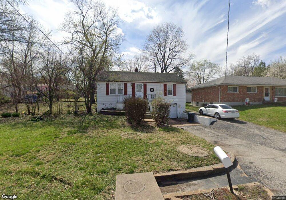
4118 Burnett Ave Saint Louis, MO 63125
Lemay NeighborhoodEstimated Value: $181,812 - $202,000
2
Beds
1
Bath
1,008
Sq Ft
$191/Sq Ft
Est. Value
About This Home
This home is located at 4118 Burnett Ave, Saint Louis, MO 63125 and is currently estimated at $192,953, approximately $191 per square foot. 4118 Burnett Ave is a home located in St. Louis County with nearby schools including Bierbaum Elementary School, Margaret Buerkle Middle School, and Mehlville High School.
Ownership History
Date
Name
Owned For
Owner Type
Purchase Details
Closed on
May 23, 2012
Sold by
Miskovic Joseph
Bought by
Farquhar David L and Farquhar Emily N
Current Estimated Value
Home Financials for this Owner
Home Financials are based on the most recent Mortgage that was taken out on this home.
Original Mortgage
$68,000
Outstanding Balance
$47,180
Interest Rate
3.93%
Mortgage Type
New Conventional
Estimated Equity
$145,773
Create a Home Valuation Report for This Property
The Home Valuation Report is an in-depth analysis detailing your home's value as well as a comparison with similar homes in the area
Home Values in the Area
Average Home Value in this Area
Purchase History
| Date | Buyer | Sale Price | Title Company |
|---|---|---|---|
| Farquhar David L | $85,000 | Integrity Land Title Co Inc |
Source: Public Records
Mortgage History
| Date | Status | Borrower | Loan Amount |
|---|---|---|---|
| Open | Farquhar David L | $68,000 |
Source: Public Records
Tax History Compared to Growth
Tax History
| Year | Tax Paid | Tax Assessment Tax Assessment Total Assessment is a certain percentage of the fair market value that is determined by local assessors to be the total taxable value of land and additions on the property. | Land | Improvement |
|---|---|---|---|---|
| 2025 | $1,780 | $36,550 | $14,970 | $21,580 |
| 2024 | $1,780 | $24,050 | $9,310 | $14,740 |
| 2023 | $1,677 | $24,050 | $9,310 | $14,740 |
| 2022 | $2,257 | $30,120 | $9,980 | $20,140 |
| 2021 | $2,072 | $30,120 | $9,980 | $20,140 |
| 2020 | $1,882 | $25,860 | $12,180 | $13,680 |
| 2019 | $1,877 | $25,860 | $12,180 | $13,680 |
| 2018 | $1,580 | $19,330 | $6,940 | $12,390 |
| 2017 | $1,576 | $19,330 | $6,940 | $12,390 |
| 2016 | $1,279 | $15,000 | $4,660 | $10,340 |
| 2015 | $1,206 | $15,000 | $4,660 | $10,340 |
| 2014 | $1,374 | $17,050 | $2,930 | $14,120 |
Source: Public Records
Map
Nearby Homes
- 4127 Burnett Ave
- 1905 Mansard Dr Unit 1905
- 1871 Mansard Dr Unit 1917
- 4203 Lions Chase Dr
- 4259 Burnett Walk Unit 4259
- 1908 Union Rd Unit 1908
- 1918 Union Rd
- 9920 Bunker Hill Dr Unit E
- 9030 Villaridge Ct Unit 53
- 2245 Pecan Dr
- 9883 Ione Ln
- 10010 Bunker Hill Dr Unit H
- 10018 Bunker Hill Dr Unit G
- 9197 Villaridge Ct
- 9070 Villaridge Ct Unit 38
- 9117 Villaridge Ct Unit E
- 9925 Bunker Hill Dr Unit G
- 9925 Bunker Hill Dr Unit F
- 9862 Glenmont Dr
- 2324 Birch Dr
- 4126 Burnett Ave
- 4112 Burnett Ave
- 1915 Burnett Ave
- 4117 Burnett Ave
- 4121 Burnett Ave
- 4115 Burnett Ave
- 1919 Burnett Ave
- 4123 Burnett Ave
- 1925 Burnett Ave
- 4105 Burnett Ave
- 1917 Mansard Dr Unit 1917
- 1915 Mansard Dr Unit 1915
- 1907 Mansard Dr Unit 1907
- 1951 Mansard Dr
- 1953 Mansard Dr Unit 1953
- 4109 Reavis Barracks Rd
- 4115 Reavis Barracks Rd
- 1909 Mansard Dr Unit 1909
- 1949 Mansard Dr Unit 1949
- 1873 Mansard Dr Unit 1873