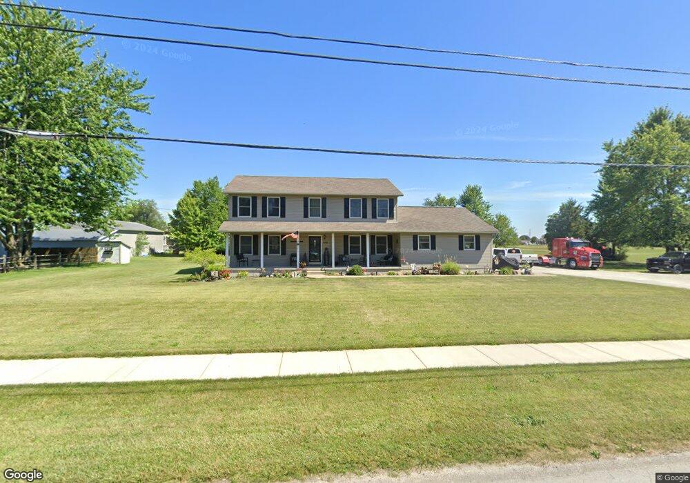
412 E Maple St North Baltimore, OH 45872
Estimated Value: $231,000 - $324,000
4
Beds
3
Baths
2,200
Sq Ft
$119/Sq Ft
Est. Value
About This Home
This home is located at 412 E Maple St, North Baltimore, OH 45872 and is currently estimated at $261,186, approximately $118 per square foot. 412 E Maple St is a home located in Wood County with nearby schools including E.A. Powell Elementary School, North Baltimore Middle School, and North Baltimore High School.
Ownership History
Date
Name
Owned For
Owner Type
Purchase Details
Closed on
Sep 10, 2019
Sold by
Carles Monty J and Carles Annie R
Bought by
Carles Annie R and Carles Ann R
Current Estimated Value
Purchase Details
Closed on
Apr 17, 2001
Sold by
Ryan Patrick T and Ryan Patrick T
Bought by
Carles Monty J and Carles Annie R
Purchase Details
Closed on
Jul 13, 1999
Sold by
Waaland Gregory and Waaland Diana
Bought by
Ryan Patrick T
Home Financials for this Owner
Home Financials are based on the most recent Mortgage that was taken out on this home.
Original Mortgage
$15,200
Interest Rate
7.43%
Purchase Details
Closed on
Jul 17, 1990
Bought by
Waaland Patricia Ann
Create a Home Valuation Report for This Property
The Home Valuation Report is an in-depth analysis detailing your home's value as well as a comparison with similar homes in the area
Home Values in the Area
Average Home Value in this Area
Purchase History
| Date | Buyer | Sale Price | Title Company |
|---|---|---|---|
| Carles Annie R | -- | None Available | |
| Carles Monty J | $19,000 | -- | |
| Ryan Patrick T | $16,500 | American Title Agency | |
| Waaland Patricia Ann | -- | -- |
Source: Public Records
Mortgage History
| Date | Status | Borrower | Loan Amount |
|---|---|---|---|
| Previous Owner | Ryan Patrick T | $15,200 |
Source: Public Records
Tax History
| Year | Tax Paid | Tax Assessment Tax Assessment Total Assessment is a certain percentage of the fair market value that is determined by local assessors to be the total taxable value of land and additions on the property. | Land | Improvement |
|---|---|---|---|---|
| 2025 | $2,980 | $78,225 | $5,110 | $73,115 |
| 2024 | $3,486 | $78,225 | $5,110 | $73,115 |
| 2023 | $3,486 | $78,230 | $5,110 | $73,120 |
| 2021 | $3,267 | $62,480 | $4,310 | $58,170 |
| 2020 | $3,362 | $62,480 | $4,310 | $58,170 |
| 2019 | $2,896 | $52,370 | $4,310 | $48,060 |
| 2018 | $2,891 | $52,370 | $4,310 | $48,060 |
| 2017 | $2,843 | $52,370 | $4,310 | $48,060 |
| 2016 | $2,603 | $48,690 | $4,310 | $44,380 |
| 2015 | $2,603 | $48,690 | $4,310 | $44,380 |
| 2014 | $2,664 | $47,990 | $3,610 | $44,380 |
| 2013 | $3,072 | $47,990 | $3,610 | $44,380 |
Source: Public Records
Map
Nearby Homes
- Lot 112 Foley Run
- 122 W Broadway St
- 12078 Eagleville Rd
- 115 S 2nd St
- 306 S Tarr St
- 508 W Walnut St
- 930 E Broadway St Unit LOT 73
- 930 E Broadway St
- 0000 Eagleville Rd
- 0 Oil Center Rd
- 1128 County Road 139
- 205 1/2 W Market St
- 0 Ohio 613
- 117 S Main St
- 11755 State Route 613
- 0 S Dixie Hwy
- 440 Walbridge St
- 188 Washington St
- 372 Township Rd 236
- 4014 County Road 139
- 309 Chicago Ave
- 400 Gillette St
- 406 Gillette St
- 307 Chicago Ave
- 308 Gillette St
- 501 E Maple St
- 0 Chicago Ave
- 408 Gillette St
- 306 Gillette St
- 0 Chicago Ave
- 305 Chicago Ave
- 503 E Maple St
- 304 Gillette St
- 306 Chicago Ave
- 412 Gillette St
- 303 Chicago Ave
- 302 Gillette St
- 304 Chicago Ave
- 311 Gillette St
- 301 Chicago Ave
Your Personal Tour Guide
Ask me questions while you tour the home.