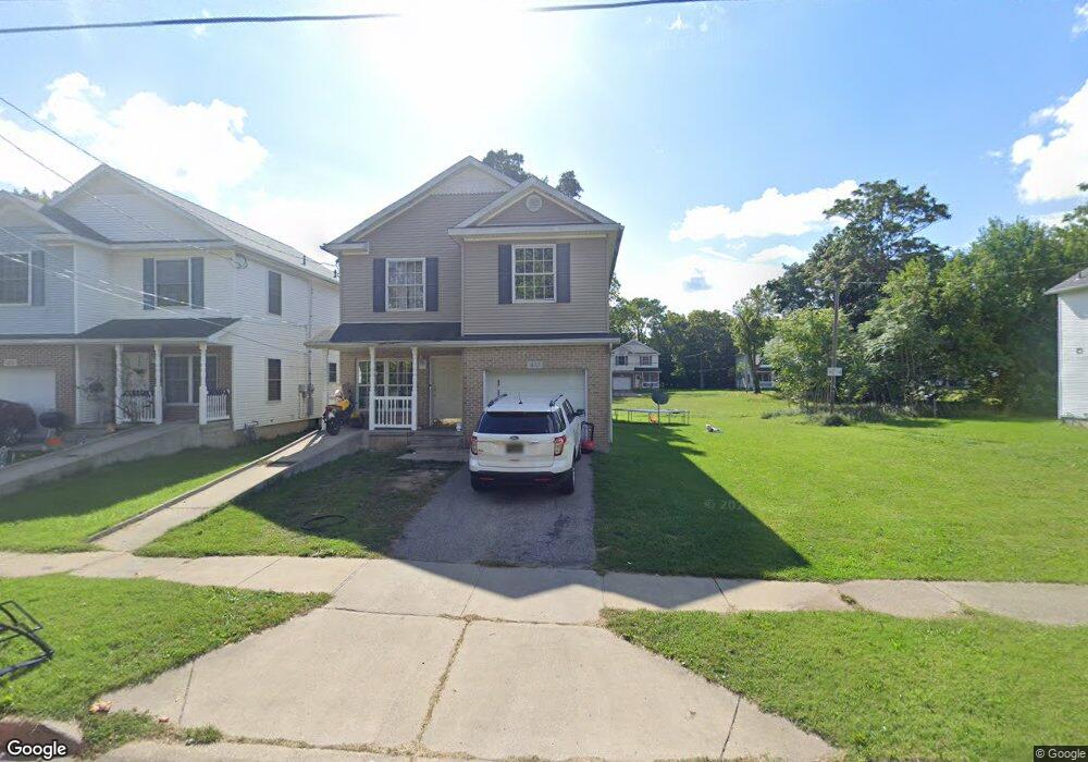
412 High St Benton Harbor, MI 49022
Estimated Value: $68,000 - $301,000
--
Bed
--
Bath
--
Sq Ft
3,787.5
Acres
About This Home
This home is located at 412 High St, Benton Harbor, MI 49022 and is currently estimated at $168,333. 412 High St is a home with nearby schools including Fair Plain Middle School, Benton Harbor High School, and Mildred C. Wells Preparatory Academy.
Ownership History
Date
Name
Owned For
Owner Type
Purchase Details
Closed on
Mar 15, 2024
Sold by
Brunson Hill Homes Limited Dividend Hous
Bought by
Michigan State Holdings Llc
Current Estimated Value
Purchase Details
Closed on
Mar 7, 2024
Sold by
Brunson Hill Homes Limited Dividend Hous
Bought by
Michigan State Holdings Llc
Purchase Details
Closed on
Aug 12, 2005
Sold by
Department Of Natural Resources For The
Bought by
Brunson Hill Homes Ltd Dividend Housing
Purchase Details
Closed on
Mar 24, 2004
Sold by
Star Development & Financial Corp
Bought by
Brunson Hill Homes Ltd Dividend Housing
Purchase Details
Closed on
Dec 23, 2003
Sold by
The City Of Benton Harbor
Bought by
Star Development & Financial Corp
Create a Home Valuation Report for This Property
The Home Valuation Report is an in-depth analysis detailing your home's value as well as a comparison with similar homes in the area
Home Values in the Area
Average Home Value in this Area
Purchase History
| Date | Buyer | Sale Price | Title Company |
|---|---|---|---|
| Michigan State Holdings Llc | -- | First American Title | |
| Michigan State Holdings Llc | -- | First American Title | |
| Brunson Hill Homes Ltd Dividend Housing | $1,120 | -- | |
| Brunson Hill Homes Ltd Dividend Housing | -- | -- | |
| Star Development & Financial Corp | -- | -- |
Source: Public Records
Tax History Compared to Growth
Tax History
| Year | Tax Paid | Tax Assessment Tax Assessment Total Assessment is a certain percentage of the fair market value that is determined by local assessors to be the total taxable value of land and additions on the property. | Land | Improvement |
|---|---|---|---|---|
| 2025 | $23 | $0 | $0 | $0 |
| 2024 | $0 | $0 | $0 | $0 |
| 2023 | -- | $0 | $0 | $0 |
| 2022 | $0 | $0 | $0 | $0 |
| 2021 | $0 | $0 | $0 | $0 |
| 2020 | $0 | $0 | $0 | $0 |
| 2019 | $0 | $0 | $0 | $0 |
| 2018 | $0 | $0 | $0 | $0 |
| 2017 | $0 | $0 | $0 | $0 |
| 2016 | $0 | $0 | $0 | $0 |
| 2015 | -- | $0 | $0 | $0 |
| 2014 | -- | $0 | $0 | $0 |
Source: Public Records
Map
Nearby Homes
- 363 Brunson Ave
- 309 High St
- 391 Pipestone St
- 378 Pipestone St
- 255 High St
- 416 E Britain Ave
- 710 Buss Ave
- 696 Highland Ave
- 419 Packard St
- VL Eighth Ninth Boughton St
- 460 Colfax Ave
- 614 Pavone St
- 576 Colfax Ave
- 806 Pitkins Ave
- 730 Superior St
- 161 Kline Ave
- 137 Cornelia St
- 694 Colfax Ave
- 6525 Territorial Rd
- 470 N Mccord St