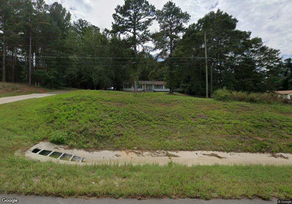
412 Highway 211 NW Winder, GA 30680
Estimated Value: $190,976 - $249,000
3
Beds
1
Bath
1,082
Sq Ft
$204/Sq Ft
Est. Value
About This Home
This home is located at 412 Highway 211 NW, Winder, GA 30680 and is currently estimated at $220,244, approximately $203 per square foot. 412 Highway 211 NW is a home located in Barrow County with nearby schools including County Line Elementary School, Russell Middle School, and Winder-Barrow High School.
Ownership History
Date
Name
Owned For
Owner Type
Purchase Details
Closed on
Feb 25, 2004
Sold by
Kouch Pong
Bought by
Kouch Pong
Current Estimated Value
Home Financials for this Owner
Home Financials are based on the most recent Mortgage that was taken out on this home.
Original Mortgage
$62,770
Interest Rate
5.54%
Mortgage Type
New Conventional
Purchase Details
Closed on
Aug 21, 1998
Sold by
Ward William Robert
Bought by
Chance William K
Purchase Details
Closed on
Jun 25, 1985
Bought by
Ward William Robert
Create a Home Valuation Report for This Property
The Home Valuation Report is an in-depth analysis detailing your home's value as well as a comparison with similar homes in the area
Home Values in the Area
Average Home Value in this Area
Purchase History
| Date | Buyer | Sale Price | Title Company |
|---|---|---|---|
| Kouch Pong | -- | -- | |
| Kouch Pong | $83,700 | -- | |
| Chance William K | $76,000 | -- | |
| Ward William Robert | $12,000 | -- |
Source: Public Records
Mortgage History
| Date | Status | Borrower | Loan Amount |
|---|---|---|---|
| Previous Owner | Kouch Pong | $62,770 |
Source: Public Records
Tax History Compared to Growth
Tax History
| Year | Tax Paid | Tax Assessment Tax Assessment Total Assessment is a certain percentage of the fair market value that is determined by local assessors to be the total taxable value of land and additions on the property. | Land | Improvement |
|---|---|---|---|---|
| 2024 | $748 | $28,931 | $10,792 | $18,139 |
| 2023 | $744 | $28,931 | $10,792 | $18,139 |
| 2022 | $736 | $28,932 | $14,000 | $14,932 |
| 2021 | $778 | $24,932 | $10,000 | $14,932 |
| 2020 | $780 | $24,932 | $10,000 | $14,932 |
| 2019 | $712 | $22,234 | $8,800 | $13,434 |
| 2018 | $697 | $22,234 | $8,800 | $13,434 |
| 2017 | $586 | $20,122 | $8,800 | $11,322 |
| 2016 | $625 | $20,122 | $8,800 | $11,322 |
| 2015 | $628 | $20,122 | $8,800 | $11,322 |
| 2014 | $508 | $15,634 | $4,312 | $11,322 |
| 2013 | -- | $18,054 | $4,312 | $13,742 |
Source: Public Records
Map
Nearby Homes
- 218 Cedar Wood Trace
- 201 Cedar Wood Trace
- 145 Cedar Wood Trace
- 213 Cedar Wood Trace
- 121 Cedar Wood Trace
- 109 Cedar Wood Trace
- 225 Cedar Wood Trace
- 133 Cedar Wood Trace
- 240 Cedar Wood Trace
- 239 Cedar Wood Trace
- 249 Cedar Wood Trace
- 254 Cedar Wood Trace
- 74 Cannon Trace Dr
- 16 Garrison Dr
- 49 Cannondale Dr
- 62 Garrison Dr
- 416 Highway 211 NW
- 159 Piney Hill Bluff Unit A
- 159 Piney Hill Bluff
- 500 Monticello Ct Unit 1
- 500 Monticello Ct
- 506 Monticello Ct Unit 1
- 494 Monticello Ct Unit 1
- 490 Monticello Ct
- 400 Highway 211 NW
- 422 Highway 211 NW Unit H
- 422 Highway 211 NW Unit F
- 422 Highway 211 NW Unit E
- 505 Monticello Ct Unit 1
- 505 Monticello Ct
- 00 Bellingrath Drive (Lot 37b) Unit 1
- 486 Monticello Ct
- 143 Piney Hill Bluff
- 499 Monticello Ct Unit 1
- 499 Monticello Ct
- 424 Highway 211 NW Unit B