Estimated Value: $190,000 - $218,000
3
Beds
1
Bath
988
Sq Ft
$203/Sq Ft
Est. Value
About This Home
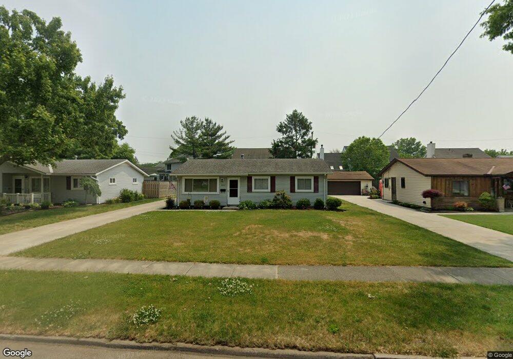
This home is located at 412 Laurel Dr, Berea, OH 44017 and is currently estimated at $200,859, approximately $203 per square foot. 412 Laurel Dr is a home located in Cuyahoga County with nearby schools including Grindstone Elementary School, Berea-Midpark Middle School, and Berea-Midpark High School.
Ownership History
Date
Name
Owned For
Owner Type
Purchase Details
Closed on
Dec 15, 2020
Sold by
Hodge William E and Hodge Theresa M
Bought by
412 Laurel Drive Llc
Current Estimated Value
Purchase Details
Closed on
Mar 3, 2010
Sold by
Martin Stanley P
Bought by
Hodge William E and Hodge Theresa M
Purchase Details
Closed on
Aug 8, 2005
Sold by
Martin Stanley P and Martin Cynthia M
Bought by
Martin Stanley P
Home Financials for this Owner
Home Financials are based on the most recent Mortgage that was taken out on this home.
Original Mortgage
$112,050
Interest Rate
5.66%
Mortgage Type
New Conventional
Purchase Details
Closed on
Mar 12, 1997
Sold by
Spencer Jeffrey W
Bought by
Martin Stanley P and Martin Cynthia M
Home Financials for this Owner
Home Financials are based on the most recent Mortgage that was taken out on this home.
Original Mortgage
$94,888
Interest Rate
7.95%
Mortgage Type
FHA
Purchase Details
Closed on
Nov 6, 1992
Sold by
Eisele Joanne M
Bought by
Spencer Jeffrey W
Purchase Details
Closed on
Apr 17, 1991
Sold by
Eisele Matthew J
Bought by
Eisele Joanne M
Purchase Details
Closed on
Sep 16, 1977
Sold by
Kinnear Lloyd E and Kinnear Patricia J
Bought by
Eisele Matthew J
Purchase Details
Closed on
Jan 1, 1975
Bought by
Kinnear Lloyd E and Kinnear Patricia J
Create a Home Valuation Report for This Property
The Home Valuation Report is an in-depth analysis detailing your home's value as well as a comparison with similar homes in the area
Home Values in the Area
Average Home Value in this Area
Purchase History
| Date | Buyer | Sale Price | Title Company |
|---|---|---|---|
| 412 Laurel Drive Llc | -- | None Available | |
| Hodge William E | $50,400 | Maximum Title | |
| Martin Stanley P | -- | Maximum Title | |
| Martin Stanley P | $95,000 | -- | |
| Spencer Jeffrey W | $79,900 | -- | |
| Eisele Joanne M | -- | -- | |
| Eisele Matthew J | $37,500 | -- | |
| Kinnear Lloyd E | -- | -- |
Source: Public Records
Mortgage History
| Date | Status | Borrower | Loan Amount |
|---|---|---|---|
| Previous Owner | Martin Stanley P | $112,050 | |
| Previous Owner | Martin Stanley P | $94,888 |
Source: Public Records
Tax History
| Year | Tax Paid | Tax Assessment Tax Assessment Total Assessment is a certain percentage of the fair market value that is determined by local assessors to be the total taxable value of land and additions on the property. | Land | Improvement |
|---|---|---|---|---|
| 2024 | $3,362 | $56,840 | $12,215 | $44,625 |
| 2023 | $3,003 | $42,530 | $9,870 | $32,660 |
| 2022 | $2,984 | $42,530 | $9,870 | $32,660 |
| 2021 | $2,894 | $42,530 | $9,870 | $32,660 |
| 2020 | $2,766 | $36,050 | $8,370 | $27,690 |
| 2019 | $2,692 | $103,000 | $23,900 | $79,100 |
| 2018 | $2,622 | $36,050 | $8,370 | $27,690 |
| 2017 | $2,751 | $34,380 | $7,110 | $27,270 |
| 2016 | $2,730 | $34,380 | $7,110 | $27,270 |
| 2015 | $2,716 | $34,380 | $7,110 | $27,270 |
| 2014 | $2,716 | $36,190 | $7,490 | $28,700 |
Source: Public Records
Map
Nearby Homes
- 379 Laurel Dr
- 428 Park Place
- 446 Redwood Dr
- 487 Karen Dr
- 160 Stonepointe Dr
- 725 Shakespeare Dr
- 100 River Rock Way
- 6574 Burton Dr
- 93 W 5th Ave
- 146 Marian Ln
- 628 Lindbergh Blvd
- 404 Crescent Dr
- 160 Marian Ln Unit 6A
- 56 3rd Ave
- 0 River Rd Unit 5169658
- 211 W Bridge St
- 216 Kraft St
- 209 Gibson St
- 7461 River Rd
- 287 Edgewood Dr
Your Personal Tour Guide
Ask me questions while you tour the home.