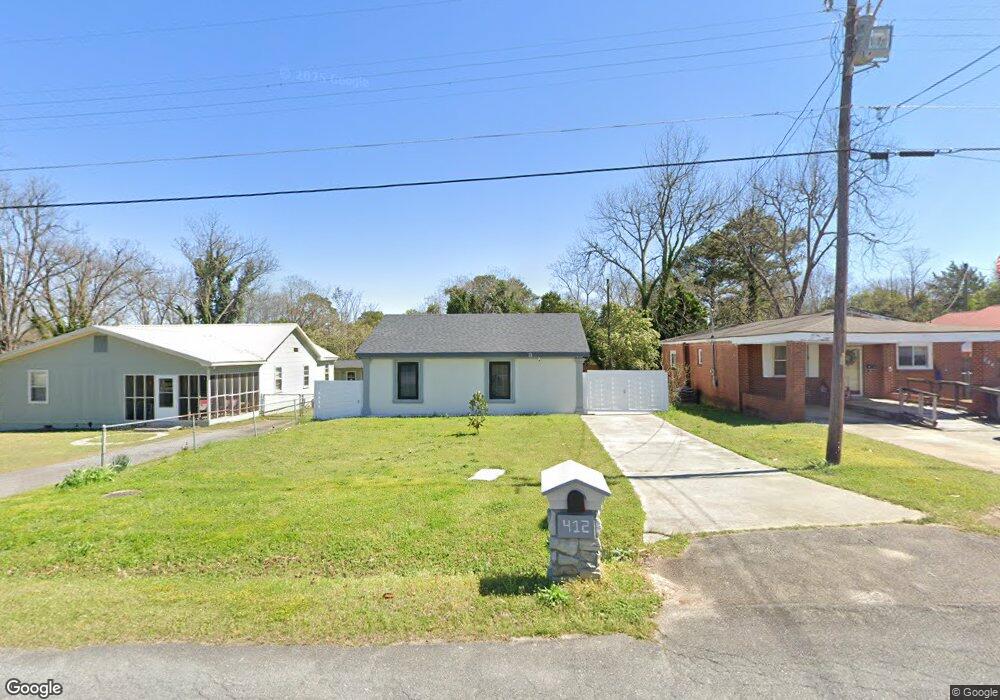
412 Myrtle St Warner Robins, GA 31093
Estimated Value: $79,186 - $106,000
--
Bed
1
Bath
921
Sq Ft
$95/Sq Ft
Est. Value
About This Home
This home is located at 412 Myrtle St, Warner Robins, GA 31093 and is currently estimated at $87,047, approximately $94 per square foot. 412 Myrtle St is a home located in Houston County with nearby schools including C. B. Watson Primary School, Pearl Stephens Elementary School, and Huntington Middle School.
Ownership History
Date
Name
Owned For
Owner Type
Purchase Details
Closed on
Nov 17, 2003
Sold by
Marrett Margaret Kathleen
Bought by
Marrett Bobby V
Current Estimated Value
Purchase Details
Closed on
Jun 29, 1999
Sold by
Marrett Bobby V
Bought by
Marrett Margaret Kathleen
Purchase Details
Closed on
Jun 15, 1999
Sold by
Marrett Bobby V
Bought by
Marrett Margaret Kathleen
Purchase Details
Closed on
Mar 10, 1993
Sold by
City Of Warner Robins
Bought by
Marrett Bobby V
Purchase Details
Closed on
Nov 3, 1992
Sold by
Right Of Way
Bought by
Marrett Bobby V
Purchase Details
Closed on
Oct 11, 1984
Sold by
Biggs Travis B
Bought by
Marrett Bobby V
Purchase Details
Closed on
Oct 7, 1982
Sold by
Biggs Elizabeth Estate
Bought by
Biggs Travis B
Purchase Details
Closed on
Jan 10, 1955
Bought by
Biggs Elizabeth S and Biggs Travis
Create a Home Valuation Report for This Property
The Home Valuation Report is an in-depth analysis detailing your home's value as well as a comparison with similar homes in the area
Home Values in the Area
Average Home Value in this Area
Purchase History
| Date | Buyer | Sale Price | Title Company |
|---|---|---|---|
| Marrett Bobby V | -- | -- | |
| Marrett Margaret Kathleen | -- | -- | |
| Marrett Margaret Kathleen | -- | -- | |
| Marrett Bobby V | -- | -- | |
| Marrett Bobby V | -- | -- | |
| Marrett Bobby V | -- | -- | |
| Biggs Travis B | -- | -- | |
| Biggs Elizabeth S | -- | -- |
Source: Public Records
Tax History Compared to Growth
Tax History
| Year | Tax Paid | Tax Assessment Tax Assessment Total Assessment is a certain percentage of the fair market value that is determined by local assessors to be the total taxable value of land and additions on the property. | Land | Improvement |
|---|---|---|---|---|
| 2024 | $479 | $14,640 | $1,080 | $13,560 |
| 2023 | $404 | $12,240 | $1,080 | $11,160 |
| 2022 | $254 | $11,040 | $1,080 | $9,960 |
| 2021 | $19 | $9,880 | $1,080 | $8,800 |
| 2020 | $22 | $10,040 | $1,080 | $8,960 |
| 2019 | $21 | $10,040 | $1,080 | $8,960 |
| 2018 | $21 | $10,040 | $1,080 | $8,960 |
| 2017 | $21 | $10,040 | $1,080 | $8,960 |
| 2016 | $21 | $10,040 | $1,080 | $8,960 |
| 2015 | $21 | $10,040 | $1,080 | $8,960 |
| 2014 | -- | $10,200 | $1,080 | $9,120 |
| 2013 | -- | $10,200 | $1,080 | $9,120 |
Source: Public Records
Map
Nearby Homes
- 404 N 5th St
- 100 Chuck Cir
- 104 Lady Ln
- 118 Arnold Blvd
- 212 Arnold Blvd
- 214 S 3rd St
- 301 Doyle St
- 304 S 2nd St
- 308 Camellia Cir
- 215 Camellia Cir
- 311 Arnold Blvd
- 101 Jacobs Ln
- 117 Forest Park Dr
- 206 Sunstede Rd
- 102 Camellia Cir
- 99 Green St Unit 101 Green Street
- 212 Orchard Way
- 127 Edna Place
- 105 Angela Ave
- 116 Tabor Dr