Estimated payment $1,899/month
Highlights
- Traditional Architecture
- No HOA
- Double Pane Windows
- Espy Elementary School Rated A
- Covered Patio or Porch
- Walk-In Closet
About This Home
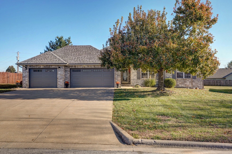
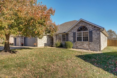
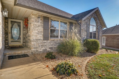
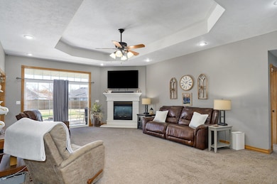
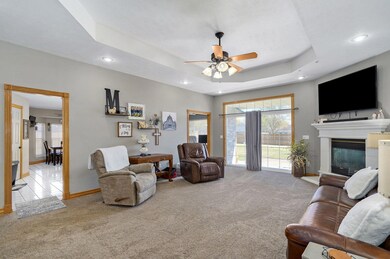
Welcome to 412 S Bryant St — where space, style, and function perfectly come together in the heart of Nixa. This stunning all-brick home stands out from the moment you arrive, but the real showstopper is the oversized 3-car garage. With an impressive 25-foot-deep third bay and a total of 892 sq ft of garage space, you have room for your boat, workshop, gym, or all the toys — and still have space left over. A built-in workbench is already in place for weekend projects, hobbyists, or DIY creatives. Inside, this home lives large with nearly 1,900 sq ft of thoughtfully designed space. The layout offers flexibility with two dining areas — or convert one into a stylish home office like the current owner does. The rooms feel bright, open, and welcoming, making daily living and entertaining effortless. Recent big-ticket upgrades mean comfort and peace of mind: -New roof, guttering, and garage doors/openers (2024)
-New privacy fence (2020)
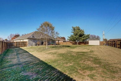
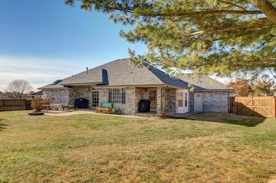
-New HVAC (2015) Step outside and fall in love with the massive backyard — a rare find in this location. Picture summer BBQs, a large garden, a play area, or even a pool. Whatever your dream outdoor space looks like, this yard can handle it. An 8×14 storage shed offers additional room for lawn equipment, tools, or outdoor toys. This home has been gently lived in, lovingly cared for, and truly move-in ready. Warm, inviting, and full of possibilities — all while being minutes from Nixa schools, shopping, dining, and parks. Homes like this don't come around often! Come see why 412 S Bryant St should be your next move!
Home Details
Home Type
- Single Family
Est. Annual Taxes
- $2,031
Year Built
- Built in 1996
Lot Details
- 0.28 Acre Lot
- Lot Dimensions are 65.5x188.1
- Property is Fully Fenced
- Privacy Fence
- Landscaped
Home Design
- Traditional Architecture
- Four Sided Brick Exterior Elevation
Interior Spaces
- 1,897 Sq Ft Home
- 1-Story Property
- Sound System
- Ceiling Fan
- Gas Fireplace
- Double Pane Windows
- Fire and Smoke Detector
- Washer and Dryer Hookup
Kitchen
- Stove
- Microwave
- Dishwasher
- Disposal
Flooring
- Carpet
- Tile
- Vinyl
Bedrooms and Bathrooms
- 3 Bedrooms
- Walk-In Closet
- 2 Full Bathrooms
- Walk-in Shower
Parking
- 3 Car Attached Garage
- Driveway
Outdoor Features
- Covered Patio or Porch
- Storage Shed
- Rain Gutters
Schools
- Nx Espy/Inman Elementary School
- Nixa High School
Utilities
- Forced Air Heating and Cooling System
- Heating System Uses Natural Gas
- Gas Water Heater
- Water Softener is Owned
- Internet Available
Community Details
- No Home Owners Association
- Hedgpeth Smith Subdivision
Listing and Financial Details
- Assessor Parcel Number 100614004012003000
Map
Home Values in the Area
Average Home Value in this Area
Tax History
| Year | Tax Paid | Tax Assessment Tax Assessment Total Assessment is a certain percentage of the fair market value that is determined by local assessors to be the total taxable value of land and additions on the property. | Land | Improvement |
|---|---|---|---|---|
| 2024 | $1,911 | $30,670 | -- | -- |
| 2023 | $1,911 | $30,670 | $0 | $0 |
| 2022 | $1,772 | $28,390 | $0 | $0 |
| 2021 | $1,773 | $28,390 | $0 | $0 |
| 2020 | $1,582 | $24,190 | $0 | $0 |
| 2019 | $1,582 | $24,190 | $0 | $0 |
| 2018 | $1,474 | $24,190 | $0 | $0 |
| 2017 | $1,474 | $24,190 | $0 | $0 |
| 2016 | $1,451 | $24,190 | $0 | $0 |
| 2015 | $1,453 | $24,190 | $24,190 | $0 |
| 2014 | $1,412 | $24,090 | $0 | $0 |
| 2013 | $14 | $24,090 | $0 | $0 |
| 2011 | $14 | $48,180 | $0 | $0 |
Property History
| Date | Event | Price | List to Sale | Price per Sq Ft |
|---|---|---|---|---|
| 12/02/2025 12/02/25 | Price Changed | $329,900 | -2.9% | $174 / Sq Ft |
| 11/11/2025 11/11/25 | For Sale | $339,900 | -- | $179 / Sq Ft |
Purchase History
| Date | Type | Sale Price | Title Company |
|---|---|---|---|
| Warranty Deed | -- | Choice Escrow & Land Ttl Llc |
Mortgage History
| Date | Status | Loan Amount | Loan Type |
|---|---|---|---|
| Open | $164,750 | New Conventional |
Source: Southern Missouri Regional MLS
MLS Number: 60309596
APN: 10-0.6-14-004-012-003.000
Disclaimer: Certain information contained herein is derived from information provided by parties other than Homes.com. All information provided is deemed reliable, but is not guaranteed to be accurate and should be independently verified.
![]() The data relating to real estate for sale on this web page comes in part from the Internet Data Exchange (IDX) of the Southern Missouri Regional MLS, LLC, Inc. Real estate listings held by Brokerage firms other than [Displaying Broker’s Name] are marked with the IDX logo and detailed information about them includes the name of the listing Brokers. The information being provided is for consumers’ personal, noncommercial use and may not be used for any purpose other than to identify prospective properties consumers may be interested in purchasing. The information being provided is not guaranteed, and all information should be verified by the consumer. Any representation that a web site contains all listings shall only mean that the website contains all listing available to the public through the IDX data feed. There may be other properties offered through a REALTOR® that have not been displayed on this site. © 2025 Southern Missouri Regional MLS, LLC. All rights reserved.
The data relating to real estate for sale on this web page comes in part from the Internet Data Exchange (IDX) of the Southern Missouri Regional MLS, LLC, Inc. Real estate listings held by Brokerage firms other than [Displaying Broker’s Name] are marked with the IDX logo and detailed information about them includes the name of the listing Brokers. The information being provided is for consumers’ personal, noncommercial use and may not be used for any purpose other than to identify prospective properties consumers may be interested in purchasing. The information being provided is not guaranteed, and all information should be verified by the consumer. Any representation that a web site contains all listings shall only mean that the website contains all listing available to the public through the IDX data feed. There may be other properties offered through a REALTOR® that have not been displayed on this site. © 2025 Southern Missouri Regional MLS, LLC. All rights reserved.
SOMO MLS respects the intellectual property rights of others and expects you to do the same. Per the DMCA, SOMO MLS will respond expeditiously to claims of copyright infringement on the Site if submitted to SOMO MLS' s Copyright Agent as described below. Upon receipt of a notice alleging copyright infringement, SOMO MLS will take whatever action it deems appropriate within its sole discretion, including removal of the allegedly infringing materials. If you believe that your intellectual property rights have been violated by SOMO MLS or by a third party who has uploaded materials to the Site, please provide the following information to SOMO MLS' s designated Copyright Agent listed below:
a. A description of the copyrighted work or other intellectual property that you claim has been infringed;
b. A description of where the material that you claim is infringing is located on the Site;
c. An address, telephone number, and e-mail address where SOMO MLS can contact you and, if different, an e-mail address where the alleged infringing party, if not SOMO MLS, can contact you;
d. A statement that you have a good-faith belief that the use is not authorized by the copyright owner or other intellectual property rights owner, by its agent, or by law;
e. A statement by you under penalty of perjury that the information in your notice is accurate and that you are the copyright or intellectual property owner or are authorized to act on the owner's behalf;
f. Your electronic or physical signature. SOMO MLS may request additional information before removing any allegedly infringing material.
In the event SOMO MLS removes the allegedly infringing materials, SOMO MLS will immediately notify the person responsible for posting such materials that SOMO MLS removed or disabled access to the materials. SOMO MLS may also provide the responsible person with your e-mail address so that the person may respond to your allegations. SOMO MLS reserves the right to terminate, limit or suspend any user's access to the Site in the event of repeated infringing activity. If you believe that a user of this Site is a repeat infringer, please follow the above instructions to contact SOMO MLS's Copyright Agent. Please include sufficient information to assist SOMO MLS in determining that the user repeatedly engaged in infringing activity. SOMO MLS registered a designated agent with the Copyright Office pursuant to 17 U.S.C. 512(c). SOMO MLS's designated Copyright Agent is: Jeff Kester 1310 Primrose, Springfield, MO 65804, Phone: 417-883-1226, Email: jeff@gsbor.com
- 403 S Bryant St
- 848 S Somerset Dr
- Sw Corner Highway 160 & St S
- 000 West St
- 404 S Patricia Ave
- 204 Gate Ln
- 886 W Paddington Dr
- 601 S Gregg Rd
- 106 S Delaware St
- 000 (Tbd) Highway 160 (14 8 Acres) St
- 1334 W Mount Vernon St
- Tract 3c S Gregg Rd
- 821 S Barberry Ct
- 502 Osage Dr
- 931 W Butterfield Dr
- 104 Willow Ln
- 138 W Silver Oak St
- 1216 W Verna Ln
- 000 Croley Blvd Unit Lots 12,13, 14
- 609 W Arbor Glenn Dr
- 317 S Market St
- 1309 W Eaglewood Dr
- 656 E Spring Valley Cir
- 428 W White Ash Rd
- 829 S Parkside Cir
- 112 N Peach Brook
- 120 N Peach Brook
- 106 E Greenbriar Dr
- 226-236 W Tracker Rd
- 528 N Mary Lynn Ln
- 1012-1014 N 26th St
- 2145 W Bingham St
- 2349 N 20th St
- 2011 W Bingham St
- 4800 N 22nd St
- 2390 W Spring Dr
- 5551 N Graze St
- 5553 N Graze St
- 5910 N 23rd St
- 5955 S National Ave
