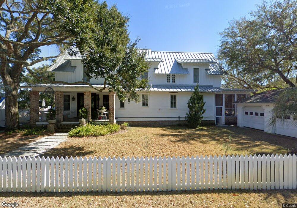
412 Station 14 St Sullivans Island, SC 29482
Sullivan's Island NeighborhoodEstimated Value: $2,968,000 - $4,918,158
3
Beds
1
Bath
2,666
Sq Ft
$1,555/Sq Ft
Est. Value
About This Home
This home is located at 412 Station 14 St, Sullivans Island, SC 29482 and is currently estimated at $4,146,386, approximately $1,555 per square foot. 412 Station 14 St is a home located in Charleston County with nearby schools including Sullivans Island Elementary School, Moultrie Middle School, and Wando High School.
Ownership History
Date
Name
Owned For
Owner Type
Purchase Details
Closed on
Jan 16, 2007
Sold by
Boehm Paul F and Boehm Judith S
Bought by
Cook Timothy J
Current Estimated Value
Purchase Details
Closed on
Nov 21, 2006
Sold by
Boehm Paul F and Boehn Judith S
Bought by
Boehm Paul F and Boehm Judith S
Purchase Details
Closed on
Sep 2, 2005
Sold by
Hain Peter M and Hain Pamela C
Bought by
Boehm Paul F and Boehm Judith S
Purchase Details
Closed on
Mar 29, 2004
Sold by
Hain Pamela Chase
Bought by
Hain Pamela C and Hain Peter M
Create a Home Valuation Report for This Property
The Home Valuation Report is an in-depth analysis detailing your home's value as well as a comparison with similar homes in the area
Home Values in the Area
Average Home Value in this Area
Purchase History
| Date | Buyer | Sale Price | Title Company |
|---|---|---|---|
| Cook Timothy J | $3,075,000 | None Available | |
| Boehm Paul F | -- | None Available | |
| Boehm Paul F | $2,875,000 | -- | |
| Hain Pamela C | -- | -- | |
| Hain Peter M | -- | -- |
Source: Public Records
Tax History Compared to Growth
Tax History
| Year | Tax Paid | Tax Assessment Tax Assessment Total Assessment is a certain percentage of the fair market value that is determined by local assessors to be the total taxable value of land and additions on the property. | Land | Improvement |
|---|---|---|---|---|
| 2024 | $12,678 | $111,210 | $0 | $0 |
| 2023 | $12,678 | $111,210 | $0 | $0 |
| 2022 | $12,504 | $111,210 | $0 | $0 |
| 2021 | $12,960 | $111,210 | $0 | $0 |
| 2020 | $13,227 | $111,210 | $0 | $0 |
| 2019 | $11,045 | $96,700 | $0 | $0 |
| 2017 | $8,587 | $85,100 | $0 | $0 |
| 2016 | $8,179 | $85,100 | $0 | $0 |
| 2015 | $8,551 | $85,100 | $0 | $0 |
| 2014 | $6,617 | $0 | $0 | $0 |
| 2011 | -- | $0 | $0 | $0 |
Source: Public Records
Map
Nearby Homes
- 1651 Atlantic Ave
- 1714 Middle St
- 932 Middle St
- 1727 Atlantic Ave
- 1750 Ion Ave
- 904 Middle St
- 1773 Atlantic Ave
- 409 Station 22 1 2 St
- 1602 Marsh Harbor Ln Unit A
- 1647 Marsh Harbor Ln
- 1608 Marsh Harbor Ln Unit C
- 2307 Ion Ave
- 967 Royall Ave
- 2414 Goldbug Ave
- 2424 Middle St
- 521 London Bridge Rd
- 301 Center St
- 242 Middle St
- 2524 Goldbug Ave
- 2524 Middle St
- 1408 Thompson Ave
- 1412 Thompson Ave
- 1319 Cove Ave
- 1406 Thompson Ave
- 1402 Thompson Ave
- 1414 Thompson Ave
- 1318 Cove Ave
- 1320 Thompson Ave
- 1315 Cove Ave
- 1418 Thompson Ave
- 1420 Thompson Ave
- 1312 Cove Ave
- 1401 Thompson Ave
- 1311 Cove Ave
- 1411 Thompson Ave
- 1424 Thompson Ave
- 1319 Thompson Ave
- 1312 Thompson Ave
- 1308 Cove Ave
- 1307 Cove Ave