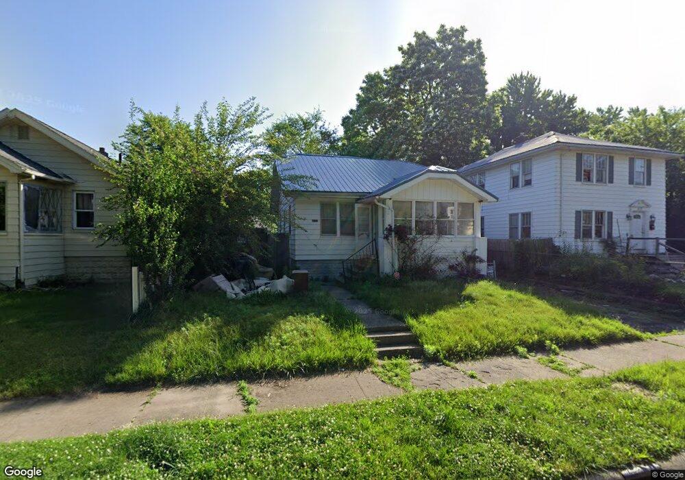
4123 Custer Ave Flint, MI 48507
Circle Drive NeighborhoodEstimated Value: $58,000 - $83,000
2
Beds
1
Bath
768
Sq Ft
$95/Sq Ft
Est. Value
About This Home
This home is located at 4123 Custer Ave, Flint, MI 48507 and is currently estimated at $72,708, approximately $94 per square foot. 4123 Custer Ave is a home located in Genesee County with nearby schools including Freeman Elementary School, Flint Southwestern Classical Academy, and International Academy of Flint (K-12).
Ownership History
Date
Name
Owned For
Owner Type
Purchase Details
Closed on
Aug 17, 2017
Sold by
Auten Rehee
Bought by
Morris Donald E
Current Estimated Value
Purchase Details
Closed on
Dec 17, 2015
Sold by
Genesee County
Bought by
Genesee County Land Bank
Purchase Details
Closed on
Feb 12, 2011
Sold by
Liv Cordes Dorothy L and Liv Dorothy L Cordes Revocable
Bought by
Gleffe George K
Purchase Details
Closed on
Nov 23, 2010
Sold by
Cordes Dorthea Lucy and Cordes Dorothea Lucy
Bought by
Liv Cordes Dorothy L and Liv Dorothy L Cordes Revocable
Purchase Details
Closed on
Apr 24, 2003
Sold by
Keys June and Cordes Dorothea
Bought by
Keys June and Cordes Dorothea
Purchase Details
Closed on
Mar 24, 2003
Sold by
Estate Of George Gleffe
Bought by
Keys June and Cordes Dorothy
Create a Home Valuation Report for This Property
The Home Valuation Report is an in-depth analysis detailing your home's value as well as a comparison with similar homes in the area
Home Values in the Area
Average Home Value in this Area
Purchase History
| Date | Buyer | Sale Price | Title Company |
|---|---|---|---|
| Morris Donald E | -- | None Available | |
| Genesee County Land Bank | -- | None Available | |
| Gleffe George K | -- | None Available | |
| Liv Cordes Dorothy L | -- | None Available | |
| Keys June | -- | -- | |
| Keys June | $14,000 | -- |
Source: Public Records
Tax History Compared to Growth
Tax History
| Year | Tax Paid | Tax Assessment Tax Assessment Total Assessment is a certain percentage of the fair market value that is determined by local assessors to be the total taxable value of land and additions on the property. | Land | Improvement |
|---|---|---|---|---|
| 2025 | $836 | $32,700 | $0 | $0 |
| 2024 | $763 | $29,200 | $0 | $0 |
| 2023 | $752 | $26,900 | $0 | $0 |
| 2022 | $0 | $22,000 | $0 | $0 |
| 2021 | $778 | $15,900 | $0 | $0 |
| 2020 | $707 | $11,300 | $0 | $0 |
| 2019 | $693 | $9,900 | $0 | $0 |
| 2018 | $681 | $8,900 | $0 | $0 |
| 2017 | $727 | $0 | $0 | $0 |
| 2016 | $722 | $0 | $0 | $0 |
| 2015 | -- | $0 | $0 | $0 |
| 2014 | -- | $0 | $0 | $0 |
| 2012 | -- | $13,400 | $13,400 | $0 |
Source: Public Records
Map
Nearby Homes
- 4127 Custer Ave
- 4205 Red Arrow Rd
- 326 Burroughs Ave
- 454 E Atherton Rd
- 621 Burroughs Ave
- 630 Buckingham Ave
- 810 Macdonald Ave
- 3614 Comanche Ave
- 3505 Comanche Ave
- 4310 Cheyenne Ave
- 4424 Cheyenne Ave
- 3115 Circle Dr
- 213 E Lakeview Ave
- 115 E Livingston Dr
- 3902 Cuthbertson St
- 1453 Carman St
- 3512 Barcey Ct
- 0 Allen St Unit 50168596
- 3343 Cheyenne Ave
- 1393 Carman St
- 4117 Custer Ave
- 4131 Custer Ave
- 4102 Menton St
- 402 Leta Ave
- 4108 Menton St
- 422 Leta Ave
- 4133 Custer Ave
- 4126 Custer Ave
- 4112 Menton St
- 4118 Custer Ave
- 4130 Custer Ave
- 4134 Custer Ave
- 4116 Menton St
- 4110 Custer Ave
- 4202 Custer Ave
- 4120 Menton St
- 4102 Custer Ave
- 415 Leta Ave
- 4201 Custer Ave
- 419 Leta Ave