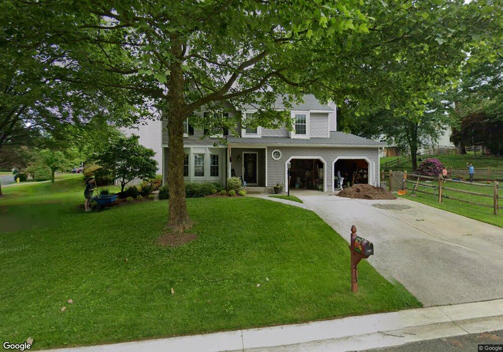
413 Abbey Cir Abingdon, MD 21009
Estimated Value: $440,000 - $485,000
Studio
3
Baths
1,856
Sq Ft
$249/Sq Ft
Est. Value
About This Home
This home is located at 413 Abbey Cir, Abingdon, MD 21009 and is currently estimated at $461,465, approximately $248 per square foot. 413 Abbey Cir is a home located in Harford County with nearby schools including Homestead-Wakefield Elementary School, Patterson Mill Middle School, and Patterson Mill High School.
Ownership History
Date
Name
Owned For
Owner Type
Purchase Details
Closed on
Dec 20, 2005
Sold by
Clark Richard D
Bought by
Mangold Brian K and Mangold Jennifer A
Current Estimated Value
Home Financials for this Owner
Home Financials are based on the most recent Mortgage that was taken out on this home.
Original Mortgage
$250,000
Outstanding Balance
$140,706
Interest Rate
6.39%
Mortgage Type
New Conventional
Estimated Equity
$320,759
Purchase Details
Closed on
May 6, 2003
Sold by
Duncan Smith F
Bought by
Clark Richard D and Clark Jennifer L
Purchase Details
Closed on
Jun 9, 1986
Sold by
Ryland Group Inc The
Bought by
Smith F Duncan
Home Financials for this Owner
Home Financials are based on the most recent Mortgage that was taken out on this home.
Original Mortgage
$105,000
Interest Rate
10.74%
Create a Home Valuation Report for This Property
The Home Valuation Report is an in-depth analysis detailing your home's value as well as a comparison with similar homes in the area
Home Values in the Area
Average Home Value in this Area
Purchase History
| Date | Buyer | Sale Price | Title Company |
|---|---|---|---|
| Mangold Brian K | $350,000 | -- | |
| Clark Richard D | $211,500 | -- | |
| Smith F Duncan | $110,600 | -- |
Source: Public Records
Mortgage History
| Date | Status | Borrower | Loan Amount |
|---|---|---|---|
| Open | Mangold Brian K | $250,000 | |
| Previous Owner | Smith F Duncan | $105,000 | |
| Closed | Clark Richard D | -- |
Source: Public Records
Tax History
| Year | Tax Paid | Tax Assessment Tax Assessment Total Assessment is a certain percentage of the fair market value that is determined by local assessors to be the total taxable value of land and additions on the property. | Land | Improvement |
|---|---|---|---|---|
| 2025 | $3,510 | $350,800 | $0 | $0 |
| 2024 | $3,510 | $328,400 | $0 | $0 |
| 2023 | $3,335 | $306,000 | $100,400 | $205,600 |
| 2022 | $3,273 | $300,333 | $0 | $0 |
| 2021 | $3,335 | $294,667 | $0 | $0 |
| 2020 | $3,335 | $289,000 | $100,400 | $188,600 |
| 2019 | $3,315 | $287,300 | $0 | $0 |
| 2018 | $3,266 | $285,600 | $0 | $0 |
| 2017 | $3,247 | $283,900 | $0 | $0 |
| 2016 | -- | $277,900 | $0 | $0 |
| 2015 | $3,324 | $271,900 | $0 | $0 |
| 2014 | $3,324 | $265,900 | $0 | $0 |
Source: Public Records
Map
Nearby Homes
- 603 E Wheel Rd
- 922 Sidehill Dr
- 2513 Kenna Ct Unit 7
- 2309 Lily Ct
- 708 Tranquil Ct
- 2608 Laurel Valley Garth
- 745 Dowers Rd
- 211 E Wheel Rd
- 903 Shelburne Rd
- 900 E Wheel Rd
- 113 Laurel Valley Ct
- 108 Laurel Valley Ct
- 1404 Strathmore Dr
- 2058 Whitney Ln
- 536 David Dr
- 200 Temple Dr
- 928 Fenario Cir
- 1510 Parkland Dr
- 2000 Treese Unit DEVONSHIRE
- 2000 Treese Unit SAVANNAH
Your Personal Tour Guide
Ask me questions while you tour the home.