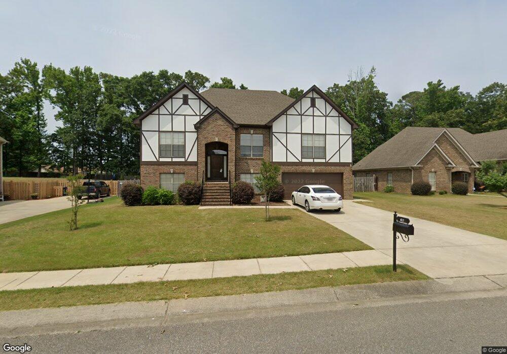
413 Ramsgate Dr Maylene, AL 35114
Estimated Value: $371,271 - $436,000
Studio
1
Bath
2,444
Sq Ft
$166/Sq Ft
Est. Value
About This Home
This home is located at 413 Ramsgate Dr, Maylene, AL 35114 and is currently estimated at $405,818, approximately $166 per square foot. 413 Ramsgate Dr is a home located in Shelby County with nearby schools including Thompson Intermediate School, Thompson Middle School, and Thompson High School.
Ownership History
Date
Name
Owned For
Owner Type
Purchase Details
Closed on
Nov 21, 2007
Sold by
Professional Homebuilders Inc
Bought by
Hill Rutherford B and Hill Sandy D
Current Estimated Value
Home Financials for this Owner
Home Financials are based on the most recent Mortgage that was taken out on this home.
Original Mortgage
$247,203
Outstanding Balance
$155,923
Interest Rate
6.32%
Mortgage Type
VA
Estimated Equity
$249,895
Purchase Details
Closed on
Jun 6, 2007
Sold by
W A Jones Construction Co Inc
Bought by
Professional Homebuilders Inc
Home Financials for this Owner
Home Financials are based on the most recent Mortgage that was taken out on this home.
Original Mortgage
$196,000
Interest Rate
6.16%
Mortgage Type
Construction
Create a Home Valuation Report for This Property
The Home Valuation Report is an in-depth analysis detailing your home's value as well as a comparison with similar homes in the area
Home Values in the Area
Average Home Value in this Area
Purchase History
| Date | Buyer | Sale Price | Title Company |
|---|---|---|---|
| Hill Rutherford B | $242,071 | None Available | |
| Professional Homebuilders Inc | $38,000 | None Available |
Source: Public Records
Mortgage History
| Date | Status | Borrower | Loan Amount |
|---|---|---|---|
| Open | Hill Rutherford B | $247,203 | |
| Previous Owner | Professional Homebuilders Inc | $196,000 |
Source: Public Records
Tax History
| Year | Tax Paid | Tax Assessment Tax Assessment Total Assessment is a certain percentage of the fair market value that is determined by local assessors to be the total taxable value of land and additions on the property. | Land | Improvement |
|---|---|---|---|---|
| 2024 | $1,839 | $34,060 | $0 | $0 |
| 2023 | $1,664 | $31,580 | $0 | $0 |
| 2022 | $1,537 | $29,220 | $0 | $0 |
| 2021 | $1,407 | $26,820 | $0 | $0 |
| 2020 | $1,352 | $25,800 | $0 | $0 |
| 2019 | $1,337 | $25,520 | $0 | $0 |
| 2017 | $1,232 | $23,580 | $0 | $0 |
| 2015 | $1,185 | $22,700 | $0 | $0 |
| 2014 | $1,156 | $22,160 | $0 | $0 |
Source: Public Records
Map
Nearby Homes
- 120 Mayfair Park
- 109 Kingsley Cir
- 135 Kingsley Rd
- 306 Mayfair Cir
- 124 Kingsley Rd
- 208 Queens Gate
- 236 Queens Gate
- 501 Ramsgate Dr
- 312 Cornwall Dr
- 537 Ramsgate Dr
- 105 Abington Cir
- 544 Ramsgate Dr
- 174 Cedar Grove Pkwy
- 305 Cedar Grove Ct
- 309 Cedar Grove Ct
- 545 Ramsgate Dr
- 549 Ramsgate Dr
- 413 Cornwall Dr
- 2001 1st Ave W
- 132 Victoria Station
- 417 Ramsgate Dr
- 409 Ramsgate Dr
- 421 Ramsgate Dr
- 412 Ramsgate Dr
- 405 Ramsgate Dr
- 416 Ramsgate Dr
- 416 Ramsgate Dr
- 425 Ramsgate Dr
- 425 Ramsgate Dr
- 420 Ramsgate Dr
- 252 Parliament Pkwy
- 424 Ramsgate Dr
- 260 Parliament Pkwy
- 429 Ramsgate Dr
- 429 Ramsgate Dr Unit 380
- 401 Cedar Ln
- 248 Parliament Pkwy
- 248 Parliament Pkwy
- 305 Cromwell
- 264 Parliament Pkwy
Your Personal Tour Guide
Ask me questions while you tour the home.