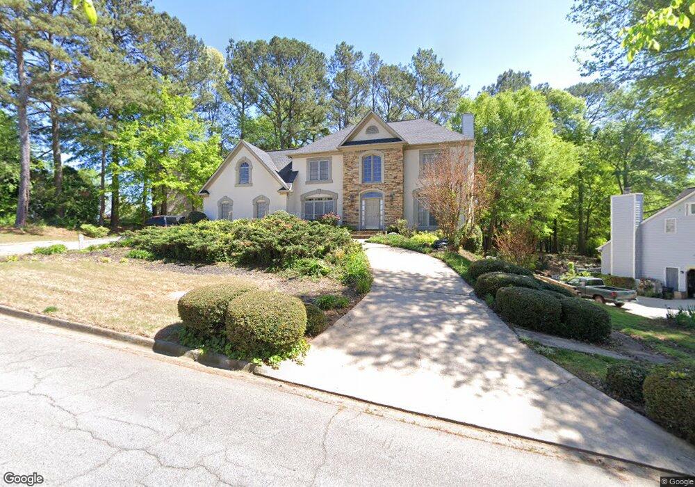
4133 Brookside Pkwy Decatur, GA 30034
Southwest DeKalb NeighborhoodEstimated Value: $373,604 - $470,000
4
Beds
3
Baths
3,642
Sq Ft
$113/Sq Ft
Est. Value
About This Home
This home is located at 4133 Brookside Pkwy, Decatur, GA 30034 and is currently estimated at $411,901, approximately $113 per square foot. 4133 Brookside Pkwy is a home located in DeKalb County with nearby schools including Bob Mathis Elementary School, Chapel Hill Middle School, and Southwest Dekalb High School.
Ownership History
Date
Name
Owned For
Owner Type
Purchase Details
Closed on
Oct 4, 2023
Sold by
Hatcher Ronald B
Bought by
Hatcher Gwendolyn B and Hatcher Ronald B
Current Estimated Value
Purchase Details
Closed on
Mar 25, 1994
Sold by
Wieland Homes
Bought by
Hatcher Ronald B
Home Financials for this Owner
Home Financials are based on the most recent Mortgage that was taken out on this home.
Original Mortgage
$183,000
Interest Rate
7.1%
Create a Home Valuation Report for This Property
The Home Valuation Report is an in-depth analysis detailing your home's value as well as a comparison with similar homes in the area
Home Values in the Area
Average Home Value in this Area
Purchase History
| Date | Buyer | Sale Price | Title Company |
|---|---|---|---|
| Hatcher Gwendolyn B | -- | -- | |
| Hatcher Ronald B | $204,000 | -- |
Source: Public Records
Mortgage History
| Date | Status | Borrower | Loan Amount |
|---|---|---|---|
| Previous Owner | Hatcher Ronald B | $183,000 |
Source: Public Records
Tax History Compared to Growth
Tax History
| Year | Tax Paid | Tax Assessment Tax Assessment Total Assessment is a certain percentage of the fair market value that is determined by local assessors to be the total taxable value of land and additions on the property. | Land | Improvement |
|---|---|---|---|---|
| 2025 | $897 | $160,000 | $14,400 | $145,600 |
| 2024 | $957 | $169,880 | $16,000 | $153,880 |
| 2023 | $957 | $98,400 | $6,080 | $92,320 |
| 2022 | $871 | $98,400 | $6,080 | $92,320 |
| 2021 | $871 | $102,520 | $6,080 | $96,440 |
| 2020 | $872 | $78,800 | $5,516 | $73,284 |
| 2019 | $853 | $78,800 | $5,516 | $73,284 |
| 2018 | $1,102 | $89,200 | $6,080 | $83,120 |
| 2017 | $907 | $58,000 | $6,080 | $51,920 |
| 2016 | $1,323 | $68,600 | $6,174 | $62,426 |
| 2014 | $1,320 | $39,120 | $6,080 | $33,040 |
Source: Public Records
Map
Nearby Homes
- 3878 Brookside Pkwy
- 4062 Brookside Pkwy
- 3740 Brown Dr
- 3865 Lehigh Blvd
- 3816 Holy Cross Ct
- 3664 Hofstra Ct
- 3778 Guilford Ct
- 3875 Mcgill Way
- 3683 Brown Dr
- 3797 Flakes Mill Rd Unit 1A
- 3879 Mcgill Ln
- 3946 Flakes Mill Rd
- 3672 Platina Park Ct
- 3826 Brandeis Way
- 3951 Mcgill Dr
- 3652 Platina Park Ct
- 4035 Shane Trail
- 3825 Shane Ct
- 4046 Shane Trail
- 3604 Spring Trace
- 3801 Brown Dr
- 4119 Brookside Pkwy
- 3783 Brown Dr
- 4107 Brookside Pkwy
- 3800 Brook Forest Trace
- 3804 Brook Forest Trace Unit 6
- 3804 Brook Forest Trace
- 3809 Brown Dr
- 4122 Brookside Pkwy
- 3827 Brookside Pkwy
- 3775 Brown Dr
- 4116 Brookside Pkwy Unit 7
- 4095 Brookside Pkwy
- 3814 Brook Forest Trace
- 4106 Brookside Pkwy
- 3799 Brook Forest Trace
- 3817 Brookside Pkwy
- 4085 Brookside Pkwy
- 3765 Brown Dr
- 3780 Holy Cross Dr