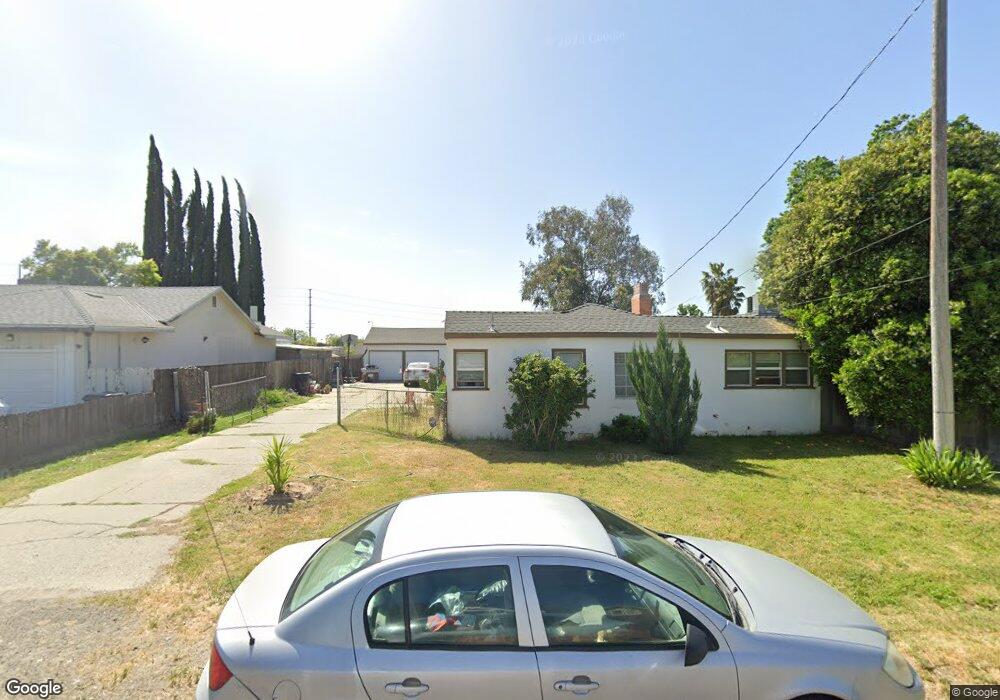
4133 N Sperry Rd Denair, CA 95316
Estimated Value: $205,000
4
Beds
2
Baths
1,900
Sq Ft
$108/Sq Ft
Est. Value
About This Home
This home is located at 4133 N Sperry Rd, Denair, CA 95316 and is currently estimated at $205,000, approximately $107 per square foot. 4133 N Sperry Rd is a home located in Stanislaus County with nearby schools including Denair Elementary School, Denair Middle School, and Denair High School.
Ownership History
Date
Name
Owned For
Owner Type
Purchase Details
Closed on
Oct 1, 2021
Sold by
Bondi Joseph A
Bought by
Bondi Joseph and The Joseph Bondi 2018 Trust
Current Estimated Value
Home Financials for this Owner
Home Financials are based on the most recent Mortgage that was taken out on this home.
Original Mortgage
$230,000
Outstanding Balance
$209,928
Interest Rate
3.01%
Estimated Equity
-$4,928
Purchase Details
Closed on
Jun 26, 2018
Sold by
Burtton Perry K
Bought by
Bondi Joseph
Home Financials for this Owner
Home Financials are based on the most recent Mortgage that was taken out on this home.
Original Mortgage
$141,000
Interest Rate
4.6%
Mortgage Type
New Conventional
Purchase Details
Closed on
Apr 19, 2018
Sold by
Bondi Joseph A
Bought by
Bondi Joseph
Purchase Details
Closed on
Oct 7, 2010
Sold by
Brutton Perry K and Brutton Patricia V
Bought by
Brutton Perry K and Brutton Patricia V
Purchase Details
Closed on
Apr 7, 2009
Sold by
The Bank Of New York Mellon
Bought by
Brutton Perry K and Brutton Patricia V
Purchase Details
Closed on
Dec 31, 2008
Sold by
Scott Malcolm J
Bought by
The Bank Of New York Mellon
Purchase Details
Closed on
Aug 1, 2007
Sold by
Scott Malcolm J
Bought by
Bio Profit Series I Llc
Purchase Details
Closed on
Mar 26, 2002
Sold by
Mid Ohio Securities
Bought by
Chariton Al
Home Financials for this Owner
Home Financials are based on the most recent Mortgage that was taken out on this home.
Original Mortgage
$101,600
Interest Rate
6.87%
Mortgage Type
Commercial
Purchase Details
Closed on
Mar 20, 2002
Sold by
Chariton Al
Bought by
Scott Malcolm J
Home Financials for this Owner
Home Financials are based on the most recent Mortgage that was taken out on this home.
Original Mortgage
$101,600
Interest Rate
6.87%
Mortgage Type
Commercial
Create a Home Valuation Report for This Property
The Home Valuation Report is an in-depth analysis detailing your home's value as well as a comparison with similar homes in the area
Home Values in the Area
Average Home Value in this Area
Purchase History
| Date | Buyer | Sale Price | Title Company |
|---|---|---|---|
| Bondi Joseph | -- | Chicago Title Company | |
| Bondi Joseph A | -- | Chicago Title Company | |
| Bondi Joseph | -- | Chicago Title Co | |
| Brutton Perry K | -- | Chicago Title Co | |
| Bondi Joseph | -- | None Available | |
| Brutton Perry K | -- | None Available | |
| Brutton Perry K | $40,000 | Orange Coast Title Company | |
| The Bank Of New York Mellon | $93,500 | None Available | |
| Bio Profit Series I Llc | $50,361 | United Capital Title Ins Co | |
| Chariton Al | $47,000 | Alliance Title Company | |
| Scott Malcolm J | $127,000 | Alliance Title Company |
Source: Public Records
Mortgage History
| Date | Status | Borrower | Loan Amount |
|---|---|---|---|
| Open | Bondi Joseph A | $230,000 | |
| Closed | Bondi Joseph | $141,000 | |
| Previous Owner | Scott Malcolm J | $101,600 |
Source: Public Records
Tax History
| Year | Tax Paid | Tax Assessment Tax Assessment Total Assessment is a certain percentage of the fair market value that is determined by local assessors to be the total taxable value of land and additions on the property. | Land | Improvement |
|---|---|---|---|---|
| 2025 | $732 | $51,495 | $38,625 | $12,870 |
| 2024 | $717 | $50,486 | $37,868 | $12,618 |
| 2023 | $698 | $49,497 | $37,126 | $12,371 |
| 2022 | $685 | $48,528 | $36,399 | $12,129 |
| 2021 | $681 | $47,578 | $35,686 | $11,892 |
| 2020 | $675 | $47,092 | $35,321 | $11,771 |
| 2019 | $645 | $46,170 | $34,629 | $11,541 |
| 2018 | $646 | $45,265 | $33,950 | $11,315 |
| 2017 | $631 | $44,379 | $33,285 | $11,094 |
| 2016 | $628 | $43,510 | $32,633 | $10,877 |
| 2015 | $599 | $42,857 | $32,143 | $10,714 |
| 2014 | $598 | $42,019 | $31,514 | $10,505 |
Source: Public Records
Map
Nearby Homes
- 4105 Chica Ave
- 3825 San Joaquin Ave
- 4117 Windgate Dr
- 4801 Glenmoor Way
- 4201 Chalmer Ct
- 4215 Riopel Ave
- 3450 Perch Dr
- 3324 Dillion Way
- 3230 Dillion Way
- 3406 Dillion Way
- 3445 Dillion Way
- 3438 Dillion Way
- 3300 Dillion Way
- 3421 Dillion Way
- 3437 Dillion Way
- 3316 Dillion Way
- 3422 Dillion Way
- 3308 Dillion Way
- 3413 Dillion Way
- 3303 Dillion Way
- 4201 S Sperry Rd
- 4141 N Sperry Rd
- 4117 N Sperry Rd
- 4101 N Sperry Rd
- 4132 N Sperry Rd
- 4217 N Sperry Rd
- 4200 Wilder Way
- 4108 N Sperry Rd
- 4100 N Sperry Rd
- 4204 Wilder Way
- 4225 N Sperry Rd
- 4231 S Sperry Rd
- 4109 N Sperry Rd
- 4300 Greenview Dr
- 4041 N Sperry Rd
- 4201 Wilder Way Unit 102
- 4201 Wilder Way
- 4232 N Sperry Rd
- 4205 Wilder Way
- 4206 Greenview Dr
Your Personal Tour Guide
Ask me questions while you tour the home.