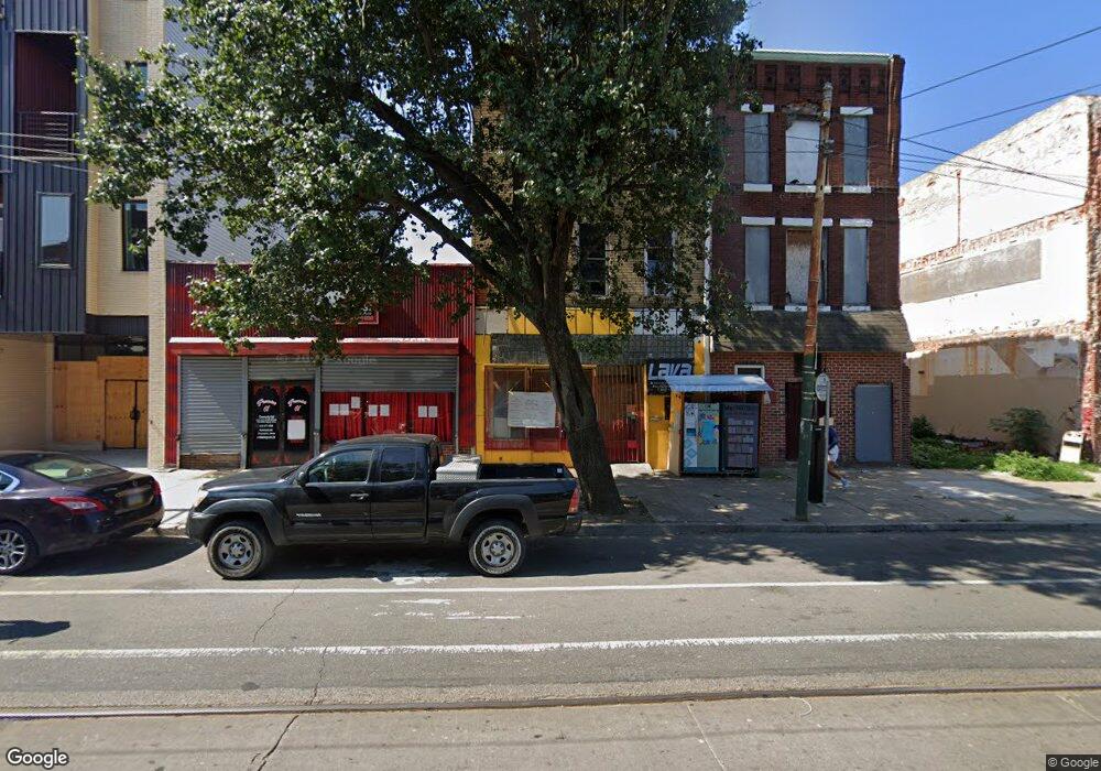
4134 Lancaster Ave Philadelphia, PA 19104
Haverford North NeighborhoodEstimated Value: $129,970
--
Bed
--
Bath
3,542
Sq Ft
$37/Sq Ft
Est. Value
About This Home
This home is located at 4134 Lancaster Ave, Philadelphia, PA 19104 and is currently estimated at $129,970, approximately $36 per square foot. 4134 Lancaster Ave is a home located in Philadelphia County with nearby schools including Martha Washington Academics Plus School, West Philadelphia High School, and Belmont Charter Elementary School.
Ownership History
Date
Name
Owned For
Owner Type
Purchase Details
Closed on
Nov 19, 2019
Sold by
Pigford Monique
Bought by
Lancaster Avenue Autonomous Zone Inc
Current Estimated Value
Purchase Details
Closed on
Aug 5, 2019
Sold by
Lancaster Avenue Autonomous Zone Inc
Bought by
Pigford Monique
Purchase Details
Closed on
Jun 14, 2004
Sold by
Sassaman Hannah
Bought by
Lancaster Avenue Autonomous Zone Inc
Purchase Details
Closed on
Jan 22, 2002
Sold by
Dinnall Harold and Heard Goggan Blair Williams
Bought by
Sassaman Hannah
Create a Home Valuation Report for This Property
The Home Valuation Report is an in-depth analysis detailing your home's value as well as a comparison with similar homes in the area
Home Values in the Area
Average Home Value in this Area
Purchase History
| Date | Buyer | Sale Price | Title Company |
|---|---|---|---|
| Lancaster Avenue Autonomous Zone Inc | -- | Fidelity National Ttl Ins Co | |
| Pigford Monique | $90,000 | Matrix Abstract Inc | |
| Lancaster Avenue Autonomous Zone Inc | $30,327 | -- | |
| Sassaman Hannah | $15,100 | -- |
Source: Public Records
Tax History Compared to Growth
Tax History
| Year | Tax Paid | Tax Assessment Tax Assessment Total Assessment is a certain percentage of the fair market value that is determined by local assessors to be the total taxable value of land and additions on the property. | Land | Improvement |
|---|---|---|---|---|
| 2025 | $1,277 | $98,000 | $19,600 | $78,400 |
| 2024 | $1,277 | $98,000 | $19,600 | $78,400 |
| 2023 | $1,277 | $91,200 | $18,249 | $72,951 |
| 2022 | $1,277 | $91,200 | $18,249 | $72,951 |
| 2021 | $1,169 | $0 | $0 | $0 |
| 2020 | $1,169 | $0 | $0 | $0 |
| 2019 | $1,160 | $0 | $0 | $0 |
| 2018 | $1,260 | $0 | $0 | $0 |
| 2017 | $1,160 | $0 | $0 | $0 |
| 2016 | $1,160 | $0 | $0 | $0 |
| 2015 | $1,111 | $0 | $0 | $0 |
| 2014 | -- | $82,900 | $16,400 | $66,500 |
| 2012 | -- | $8,960 | $1,800 | $7,160 |
Source: Public Records
Map
Nearby Homes
- 4130 42 Aspen St
- 710 N 42nd St
- 1203 N 41st St
- 4207 Aspen St
- 735 N 42nd St
- 737 N 42nd St
- 661 Brooklyn St
- 644 Brooklyn St
- 770 Brooklyn St
- 4207 Lancaster Ave
- 4115-17 Brown St
- 1719 N 42nd St
- 731 N 42nd St
- 733 N 42nd St
- 724 N 42nd St
- 876 N 42nd St
- 704 N Preston St
- 638 Hutton St
- 627 Hutton St
- 619 Hutton St
- 4136 Lancaster Ave
- 4140 Lancaster Ave
- 4142 Lancaster Ave
- 4144 Lancaster Ave
- 4123 Lancaster Ave
- 4127 Lancaster Ave
- 4125 Lancaster Ave
- 4125 Lancaster Ave Unit 2
- 4109-21 Lancaster Ave
- 4109 Lancaster Ave
- 4148 Lancaster Ave
- 4106 Aspen St
- 4112 Lancaster Ave
- 4104 Aspen St
- 4107 Lancaster Ave Unit 3
- 4102 Aspen St
- 4105 Lancaster Ave
- 4108 Lancaster Ave
- 4141 Lancaster Ave
- 715 N 42nd St