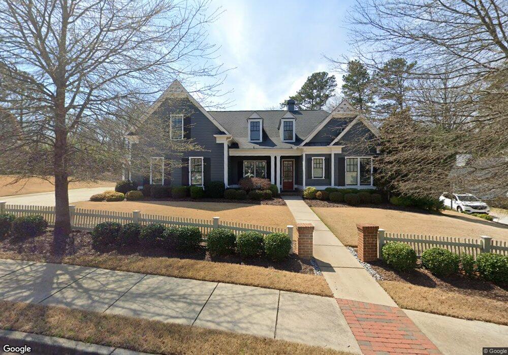
4135 Williams Point Dr Unit 9 Cumming, GA 30028
Estimated Value: $794,754 - $854,000
5
Beds
4
Baths
3,900
Sq Ft
$211/Sq Ft
Est. Value
About This Home
This home is located at 4135 Williams Point Dr Unit 9, Cumming, GA 30028 and is currently estimated at $823,939, approximately $211 per square foot. 4135 Williams Point Dr Unit 9 is a home located in Forsyth County with nearby schools including Poole's Mill Elementary School, Liberty Middle School, and North Forsyth High School.
Ownership History
Date
Name
Owned For
Owner Type
Purchase Details
Closed on
Apr 29, 2015
Sold by
Tey Investment Properties Llc
Bought by
Sr Homes Llc
Current Estimated Value
Purchase Details
Closed on
Apr 28, 2015
Sold by
Williams Point Properties Llc
Bought by
Trey Investment Properties Llc
Purchase Details
Closed on
Mar 30, 2015
Sold by
Trey Investment Properties Llc
Bought by
Sr Homes Llc
Create a Home Valuation Report for This Property
The Home Valuation Report is an in-depth analysis detailing your home's value as well as a comparison with similar homes in the area
Home Values in the Area
Average Home Value in this Area
Purchase History
| Date | Buyer | Sale Price | Title Company |
|---|---|---|---|
| Sr Homes Llc | -- | -- | |
| Trey Investment Properties Llc | $165,000 | -- | |
| Sr Homes Llc | $55,000 | -- | |
| Trey Investment Properties Llc | $55,000 | -- |
Source: Public Records
Tax History Compared to Growth
Tax History
| Year | Tax Paid | Tax Assessment Tax Assessment Total Assessment is a certain percentage of the fair market value that is determined by local assessors to be the total taxable value of land and additions on the property. | Land | Improvement |
|---|---|---|---|---|
| 2025 | $1,482 | $305,924 | $54,000 | $251,924 |
| 2024 | $1,482 | $292,260 | $50,000 | $242,260 |
| 2023 | $1,382 | $279,584 | $40,000 | $239,584 |
| 2022 | $1,464 | $212,968 | $36,000 | $176,968 |
| 2021 | $1,445 | $212,968 | $36,000 | $176,968 |
| 2020 | $1,435 | $201,272 | $28,000 | $173,272 |
| 2019 | $1,446 | $204,292 | $22,000 | $182,292 |
| 2018 | $1,417 | $185,252 | $22,000 | $163,252 |
| 2017 | $1,481 | $208,424 | $22,000 | $186,424 |
| 2016 | $5,104 | $187,064 | $22,000 | $165,064 |
| 2015 | $500 | $18,000 | $18,000 | $0 |
| 2014 | $477 | $18,000 | $0 | $0 |
Source: Public Records
Map
Nearby Homes
- 3705 Williams Point Dr
- 3945 Silverthorn Trace
- 3330 Summerpoint Crossing
- 3435 Summerdale Walk
- 3880 Deer Run Dr
- 3675 Summerpoint Crossing
- 3930 Pheasant Run Trace
- 3375 Hillshire Dr
- Harvard II Plan at Hillshire
- Hampton Plan at Hillshire
- Wesley Plan at Hillshire
- Longwood Plan at Hillshire
- Vanderbilt Plan at Hillshire
- 3390 Hillshire Dr
- 3335 Hillshire Dr
- 3330 Hillshire Dr
- 3350 Hillshire Dr
- 3985 Haven Way
- 3975 Haven Way
- 3310 Hillshire Dr
- 4135 Williams Point Dr
- 4135 Williams Point Dr
- 4145 Williams Point Dr Unit 8
- 4145 Williams Point Dr
- 4125 Williams Point Dr
- 4125 Williams Point Dr Unit 10
- 4125 Williams Point Dr
- 4155 Williams Point Dr Unit 7
- 4120 Williams Point Dr Unit 45
- 4120 Williams Point Dr
- 4120 Williams Point Dr
- 4115 Williams Point Dr Unit 11
- 4115 Williams Point Dr
- 3560 Hurt Bridge Rd
- 4150 Williams Point Dr Unit 44
- 4150 Williams Point Dr
- 4150 Williams Point Dr
- 4110 Williams Point Dr Unit 46
- 4110 Williams Point Dr
- 4110 Williams Point Dr Unit 46