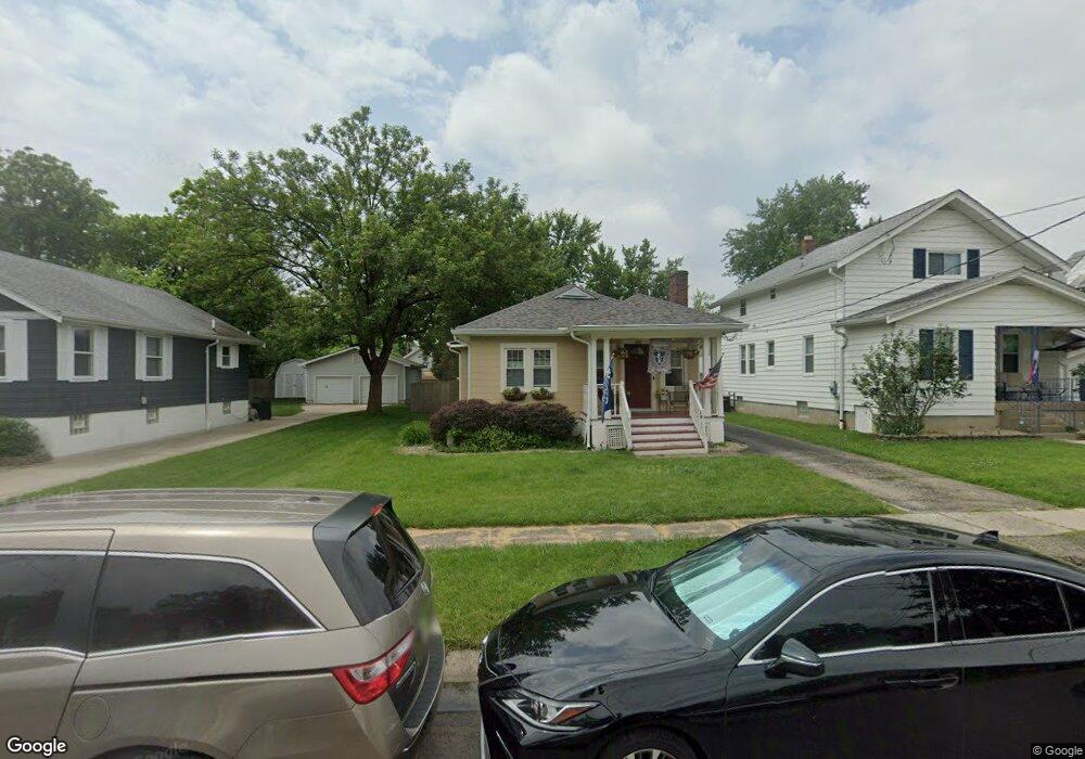
4139 Lansdowne Ave Cincinnati, OH 45236
Estimated Value: $220,923 - $260,000
3
Beds
2
Baths
1,095
Sq Ft
$224/Sq Ft
Est. Value
About This Home
This home is located at 4139 Lansdowne Ave, Cincinnati, OH 45236 and is currently estimated at $245,231, approximately $223 per square foot. 4139 Lansdowne Ave is a home located in Hamilton County with nearby schools including Amity Elementary School, Deer Park Jr/Sr High School, and Ohr Torah Cincinnati.
Ownership History
Date
Name
Owned For
Owner Type
Purchase Details
Closed on
Jul 26, 2011
Sold by
Burnett Jennifer A
Bought by
Carr Michael A
Current Estimated Value
Home Financials for this Owner
Home Financials are based on the most recent Mortgage that was taken out on this home.
Original Mortgage
$63,000
Outstanding Balance
$42,912
Interest Rate
4.53%
Mortgage Type
New Conventional
Estimated Equity
$202,319
Purchase Details
Closed on
Jun 27, 2001
Sold by
Stark Naked Properties Ltd
Bought by
Ashcraft John S and Ashcraft Amy M
Purchase Details
Closed on
Feb 16, 2001
Sold by
Burton Mary R
Bought by
Stark Naked Properties Ltd
Create a Home Valuation Report for This Property
The Home Valuation Report is an in-depth analysis detailing your home's value as well as a comparison with similar homes in the area
Home Values in the Area
Average Home Value in this Area
Purchase History
| Date | Buyer | Sale Price | Title Company |
|---|---|---|---|
| Carr Michael A | $90,000 | Attorney | |
| Ashcraft John S | $109,900 | -- | |
| Stark Naked Properties Ltd | $82,500 | -- |
Source: Public Records
Mortgage History
| Date | Status | Borrower | Loan Amount |
|---|---|---|---|
| Open | Carr Michael A | $63,000 |
Source: Public Records
Tax History
| Year | Tax Paid | Tax Assessment Tax Assessment Total Assessment is a certain percentage of the fair market value that is determined by local assessors to be the total taxable value of land and additions on the property. | Land | Improvement |
|---|---|---|---|---|
| 2025 | $3,716 | $49,823 | $11,921 | $37,902 |
| 2024 | $3,199 | $49,823 | $11,921 | $37,902 |
| 2023 | $3,206 | $49,823 | $11,921 | $37,902 |
| 2022 | $3,116 | $37,401 | $9,709 | $27,692 |
| 2021 | $3,102 | $37,401 | $9,709 | $27,692 |
| 2020 | $2,816 | $37,401 | $9,709 | $27,692 |
| 2019 | $2,859 | $34,003 | $8,827 | $25,176 |
| 2018 | $2,857 | $34,003 | $8,827 | $25,176 |
| 2017 | $2,753 | $34,003 | $8,827 | $25,176 |
| 2016 | $2,592 | $31,333 | $8,803 | $22,530 |
| 2015 | $2,348 | $31,333 | $8,803 | $22,530 |
| 2014 | $2,345 | $31,333 | $8,803 | $22,530 |
| 2013 | $2,549 | $33,688 | $9,464 | $24,224 |
Source: Public Records
Map
Nearby Homes
- 4050 O'Leary Ave
- 3990 Superior Ave
- 4025 Deer Park Ave
- 4123 Hoffman Ave
- 4244 Duneden Ave
- 4248 South Ave
- 8021 Beech Ave
- 7818 Eustis Ct
- 3805 O'Leary Ave
- 4385 Grinnell Dr
- 7722 Dalton Ave
- 4156 Linden Ave
- 6008 Winnetka Dr
- 13 Wentworth Ln
- 6829 Alpine Ave
- 4305 Myrtle Ave
- 34 Wentworth Ln
- 42 Wentworth Ln
- 7752 Montgomery Rd
- 6705 Elwynne Dr
- 4143 Lansdowne Ave
- 4137 Lansdowne Ave
- 4133 Lansdowne Ave
- 4145 Lansdowne Ave
- 4134 Superior Ave
- 4129 Lansdowne Ave
- 4132 Superior Ave
- 4136 Superior Ave
- 4147 Lansdowne Ave
- 4130 Superior Ave
- 4140 Lansdowne Ave
- 4125 Lansdowne Ave
- 4142 Lansdowne Ave
- 4138 Lansdowne Ave
- 4128 Superior Ave
- 4144 Lansdowne Ave
- 4134 Lansdowne Ave
- 4146 Lansdowne Ave
- 4126 Superior Ave
- 4130 Lansdowne Ave
Your Personal Tour Guide
Ask me questions while you tour the home.