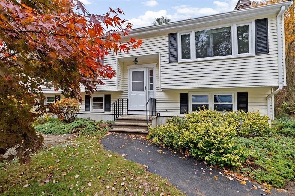
414 Branch St Mansfield, MA 02048
Estimated payment $3,756/month
Highlights
- Hot Property
- Deck
- Wooded Lot
- Harold L. Qualters Middle School Rated A-
- Property is near public transit
- Raised Ranch Architecture
About This Home
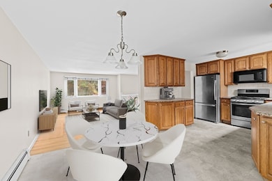
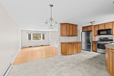
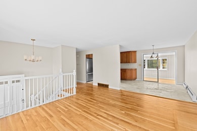
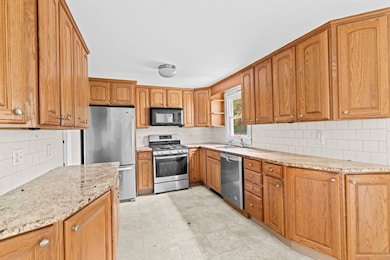
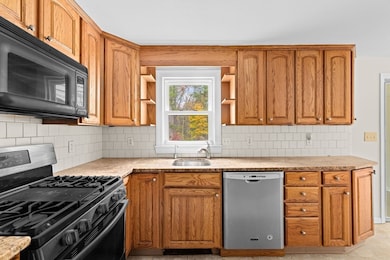
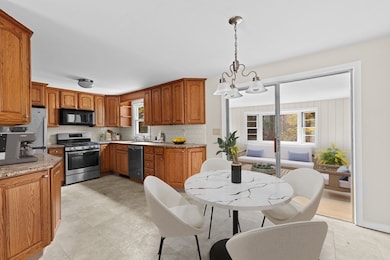
Beautifully refreshed raised ranch offers perfect blend of comfort, updates, & location. Situated minutes from downtown, schools, parks, & easy bike path access. Recent improvements include fresh interior paint &woodwork, refinished hardwood floors on main level, luxury plank flooring in lower level & sun-room, updated electrical, deck, and - new 3-bedroom septic system. The home features three bedrooms, two full baths, and a bright three-season room, with a flexible layout that includes a finished lower level—perfect for a guest suite or primary bedroom, cozy family room, and bonus space for a home office, gym, or playroom. The kitchen showcases warm oak cabinets, granite countertops, subway tile backsplash, and stainless steel appliances. Outside, enjoy a spacious backyard that borders conservation land for added privacy, plus a paved area formerly used as a basketball court for extra fun.OFFER DEADLINE - Sellers request offers in by 11/18 at 6:00pm,make good 11/19 @ 6:00pm.
Home Details
Home Type
- Single Family
Est. Annual Taxes
- $7,183
Year Built
- Built in 1970 | Remodeled
Lot Details
- 0.69 Acre Lot
- Level Lot
- Wooded Lot
Home Design
- Raised Ranch Architecture
- Frame Construction
- Shingle Roof
- Concrete Perimeter Foundation
Interior Spaces
- Insulated Windows
- Window Screens
- Sliding Doors
- Entrance Foyer
- Bonus Room
- Sun or Florida Room
- Washer
- Attic
Kitchen
- Range
- Microwave
- Dishwasher
- Stainless Steel Appliances
- Solid Surface Countertops
Flooring
- Wood
- Ceramic Tile
- Vinyl
Bedrooms and Bathrooms
- 3 Bedrooms
- Primary Bedroom on Main
- 2 Full Bathrooms
- Separate Shower
Finished Basement
- Walk-Out Basement
- Basement Fills Entire Space Under The House
- Laundry in Basement
Parking
- 3 Car Parking Spaces
- Tandem Parking
- Driveway
- Paved Parking
- Open Parking
- Off-Street Parking
Outdoor Features
- Deck
- Rain Gutters
Location
- Property is near public transit
- Property is near schools
Schools
- Qualters Middle School
- Mansfield High School
Utilities
- Central Air
- Heating System Uses Natural Gas
- Baseboard Heating
- 100 Amp Service
- Water Heater
- Private Sewer
Listing and Financial Details
- Assessor Parcel Number 2860513
Community Details
Recreation
- Park
- Bike Trail
Additional Features
- No Home Owners Association
- Shops
Map
Home Values in the Area
Average Home Value in this Area
Tax History
| Year | Tax Paid | Tax Assessment Tax Assessment Total Assessment is a certain percentage of the fair market value that is determined by local assessors to be the total taxable value of land and additions on the property. | Land | Improvement |
|---|---|---|---|---|
| 2025 | $7,183 | $545,400 | $242,000 | $303,400 |
| 2024 | $6,745 | $499,600 | $242,000 | $257,600 |
| 2023 | $6,577 | $466,800 | $242,000 | $224,800 |
| 2022 | $6,367 | $419,700 | $224,000 | $195,700 |
| 2021 | $5,955 | $387,700 | $196,100 | $191,600 |
| 2020 | $5,887 | $383,300 | $186,700 | $196,600 |
| 2019 | $5,359 | $352,100 | $155,500 | $196,600 |
| 2018 | $4,918 | $329,900 | $148,300 | $181,600 |
| 2017 | $4,942 | $329,000 | $144,100 | $184,900 |
| 2016 | $4,988 | $323,700 | $137,200 | $186,500 |
| 2015 | $4,616 | $297,800 | $137,200 | $160,600 |
Property History
| Date | Event | Price | List to Sale | Price per Sq Ft |
|---|---|---|---|---|
| 11/12/2025 11/12/25 | For Sale | $599,000 | -- | $330 / Sq Ft |
Purchase History
| Date | Type | Sale Price | Title Company |
|---|---|---|---|
| Quit Claim Deed | -- | None Available | |
| Quit Claim Deed | -- | None Available |
Source: MLS Property Information Network (MLS PIN)
MLS Number: 73454275
APN: MANS-000032-000000-000070
Disclaimer: Certain information contained herein is derived from information provided by parties other than Homes.com. All information provided is deemed reliable, but is not guaranteed to be accurate and should be independently verified.
![]() The property listing data and information, or the Images, set forth herein were provided to MLS Property Information Network, Inc. from third party sources, including sellers, lessors and public records, and were compiled by MLS Property Information Network, Inc. The property listing data and information, and the Images, are for the personal, non-commercial use of consumers having a good faith interest in purchasing or leasing listed properties of the type displayed to them and may not be used for any purpose other than to identify prospective properties which such consumers may have a good faith interest in purchasing or leasing. MLS Property Information Network, Inc. and its subscribers disclaim any and all representations and warranties as to the accuracy of the property listing data and information, or as to the accuracy of any of the Images, set forth herein.
The property listing data and information, or the Images, set forth herein were provided to MLS Property Information Network, Inc. from third party sources, including sellers, lessors and public records, and were compiled by MLS Property Information Network, Inc. The property listing data and information, and the Images, are for the personal, non-commercial use of consumers having a good faith interest in purchasing or leasing listed properties of the type displayed to them and may not be used for any purpose other than to identify prospective properties which such consumers may have a good faith interest in purchasing or leasing. MLS Property Information Network, Inc. and its subscribers disclaim any and all representations and warranties as to the accuracy of the property listing data and information, or as to the accuracy of any of the Images, set forth herein.
- 442 Ware St
- 460 Ware St
- 711 Ware St
- 12 Wilson Place
- 778 Ware St
- 14 Webb Place Unit 1B
- 16 East St Unit 2
- 631 East St Unit E203
- 631 East St Unit H102
- 38 Court St
- 409 Pratt St
- 28 Court St
- 82 Brook St
- 5 Pineview Terrace
- 18 Millfarm Dr
- 231 Spring St
- 22 Pleasant St Unit B
- 24 Barberry Rd
- 18 Columbine Rd
- 33 Azalea Rd
- 53 Fairfield Park
- 6 Bristol St Unit 2B
- 1 Samoset Ave Unit Tower
- 7 Cottage St
- 7 Cottage St Unit 3
- 270 N Main St Unit 404
- 12 Bonney Ln
- 90 High St Unit 2
- 150 Rumford Ave Unit 116
- 300 N Main St
- 1 Old Colony Rd Unit 308
- 1 Old Colony Rd Unit 216
- 12 Pratt St Unit 308
- 479 N Main St Unit A
- 18 Draper Ave Unit 2
- 10 Conners Ave
- 9 Francis Ave
- 150 Oakland St
- 647 N Main St Unit 2 Upper
- 284 Central St Unit 2
