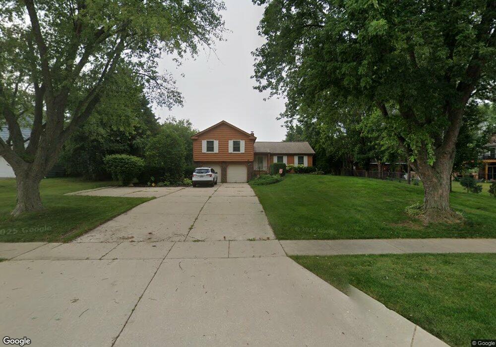
415 E Wise Rd Schaumburg, IL 60193
South Schaumburg NeighborhoodEstimated Value: $507,000 - $601,000
4
Beds
2
Baths
2,138
Sq Ft
$264/Sq Ft
Est. Value
About This Home
This home is located at 415 E Wise Rd, Schaumburg, IL 60193 and is currently estimated at $564,668, approximately $264 per square foot. 415 E Wise Rd is a home located in Cook County with nearby schools including Frederick Nerge Elementary School, Margaret Mead Junior High School, and J B Conant High School.
Ownership History
Date
Name
Owned For
Owner Type
Purchase Details
Closed on
May 25, 2006
Sold by
Nicholson Harold J and Nicholson Darlene G
Bought by
Nicholson Harold J and Nicholson Darlene G
Current Estimated Value
Purchase Details
Closed on
Feb 7, 1997
Sold by
Nicholson Harold J and Nicholson Darlene G
Bought by
Nicholson Harold J and Nicholson Darlene G
Create a Home Valuation Report for This Property
The Home Valuation Report is an in-depth analysis detailing your home's value as well as a comparison with similar homes in the area
Home Values in the Area
Average Home Value in this Area
Purchase History
| Date | Buyer | Sale Price | Title Company |
|---|---|---|---|
| Nicholson Harold J | -- | None Available | |
| Nicholson Harold J | -- | -- |
Source: Public Records
Tax History
| Year | Tax Paid | Tax Assessment Tax Assessment Total Assessment is a certain percentage of the fair market value that is determined by local assessors to be the total taxable value of land and additions on the property. | Land | Improvement |
|---|---|---|---|---|
| 2025 | $9,632 | $50,000 | $13,140 | $36,860 |
| 2024 | $9,632 | $40,351 | $11,680 | $28,671 |
| 2023 | $10,280 | $40,351 | $11,680 | $28,671 |
| 2022 | $10,280 | $44,000 | $11,680 | $32,320 |
| 2021 | $9,148 | $36,178 | $32,850 | $3,328 |
| 2020 | $9,113 | $36,178 | $32,850 | $3,328 |
| 2019 | $8,043 | $36,178 | $32,850 | $3,328 |
| 2018 | $8,530 | $34,607 | $27,740 | $6,867 |
| 2017 | $8,428 | $34,607 | $27,740 | $6,867 |
| 2016 | $8,377 | $34,607 | $27,740 | $6,867 |
| 2015 | $7,428 | $29,325 | $23,360 | $5,965 |
| 2014 | $7,374 | $29,325 | $23,360 | $5,965 |
| 2013 | $7,155 | $29,325 | $23,360 | $5,965 |
Source: Public Records
Map
Nearby Homes
- 518 E Niagara Ave
- 1100 Boston Harbor Unit 7004
- 1055 Hampton Harbor Unit 1055
- 620 S Point Dr
- 615 Newberry Dr
- 826 Thornton Ct Unit 2AL
- 1323 S Roselle Rd
- 539 Newberry Dr
- 13 W Monterey Ave
- 609 Deborah Ct
- 134 Lunt Ave
- 217 Steeple Bush Ln Unit 10242
- 207 Mountain Interval Rd Unit 7230
- 211 Steeple Bush Ln Unit 10343
- 1630 Myrtle Park St
- 100 Pratt Blvd
- 1500 Illinois St
- 712 Tipperary Ct Unit 1C
- 677 Cumberland Trail Unit 2B
- 277 Greensboro Ct Unit 4
- 1211 Summit Dr
- 1209 Summit Dr
- 1219 Summit Dr
- 427 E Wise Rd Unit 2
- 414 E Niagara Ave Unit 2
- 420 E Niagara Ave
- 1227 Summit Dr
- 1147 Durham Ct
- 433 E Wise Rd
- 1150 Durham Ct
- 1150 Rothbury Ct
- 501 E Wise Rd
- 1143 Durham Ct
- 432 E Niagara Ave
- 1233 Summit Dr
- 1210 Summit Dr
- 1200 Summit Dr
- 1146 Rothbury Ct
- 1146 Durham Ct
- 1216 Summit Dr
Your Personal Tour Guide
Ask me questions while you tour the home.