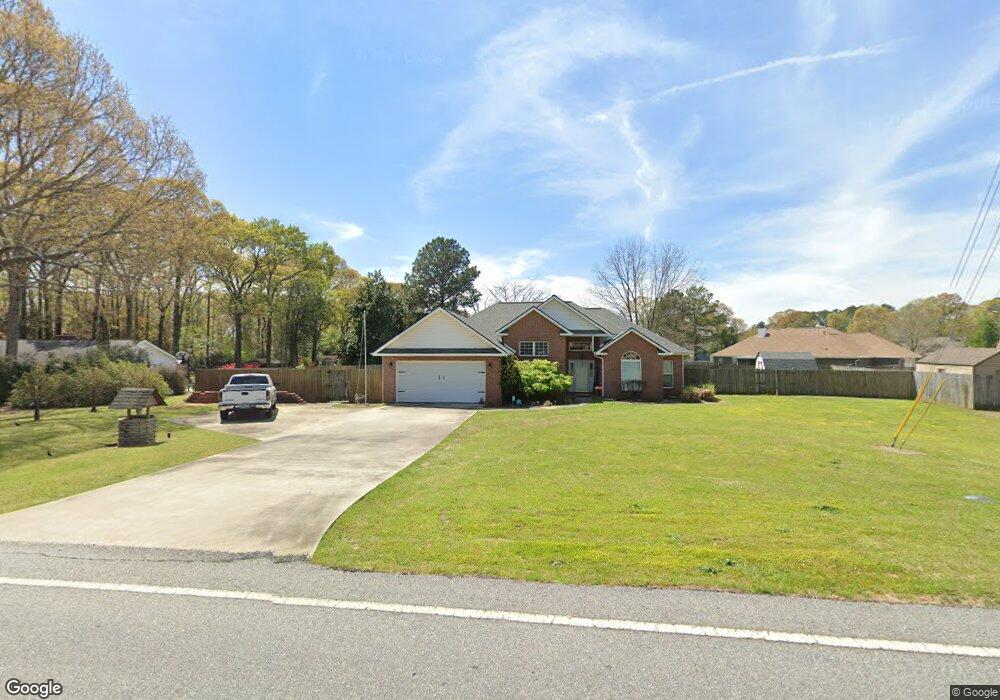
415 Tharpe Rd Unit 2 Warner Robins, GA 31088
Estimated Value: $294,000 - $309,066
3
Beds
2
Baths
2,067
Sq Ft
$147/Sq Ft
Est. Value
About This Home
This home is located at 415 Tharpe Rd Unit 2, Warner Robins, GA 31088 and is currently estimated at $303,017, approximately $146 per square foot. 415 Tharpe Rd Unit 2 is a home located in Houston County with nearby schools including Quail Run Elementary School, Warner Robins Middle School, and Houston County High School.
Ownership History
Date
Name
Owned For
Owner Type
Purchase Details
Closed on
Apr 13, 2021
Sold by
Swenson Kevin C and Swenson Kelly S
Bought by
Lewis Maria C and Ocraft Cathryn
Current Estimated Value
Home Financials for this Owner
Home Financials are based on the most recent Mortgage that was taken out on this home.
Original Mortgage
$218,500
Outstanding Balance
$195,470
Interest Rate
3.1%
Mortgage Type
New Conventional
Estimated Equity
$107,547
Purchase Details
Closed on
Aug 23, 2002
Sold by
Howdeshell Enterprises Inc
Bought by
Swenson Kevin C and Swenson Kelly S
Purchase Details
Closed on
Apr 3, 2001
Sold by
Quail Pointe Developers Inc
Bought by
Howdeshell Enterprises Inc
Create a Home Valuation Report for This Property
The Home Valuation Report is an in-depth analysis detailing your home's value as well as a comparison with similar homes in the area
Home Values in the Area
Average Home Value in this Area
Purchase History
| Date | Buyer | Sale Price | Title Company |
|---|---|---|---|
| Lewis Maria C | $230,000 | None Available | |
| Swenson Kevin C | $134,600 | -- | |
| Howdeshell Enterprises Inc | $18,000 | -- |
Source: Public Records
Mortgage History
| Date | Status | Borrower | Loan Amount |
|---|---|---|---|
| Open | Lewis Maria C | $218,500 |
Source: Public Records
Tax History
| Year | Tax Paid | Tax Assessment Tax Assessment Total Assessment is a certain percentage of the fair market value that is determined by local assessors to be the total taxable value of land and additions on the property. | Land | Improvement |
|---|---|---|---|---|
| 2025 | $2,060 | $94,280 | $9,600 | $84,680 |
| 2024 | $2,184 | $91,320 | $9,600 | $81,720 |
| 2023 | $2,191 | $90,640 | $9,600 | $81,040 |
| 2022 | $2,165 | $89,560 | $9,600 | $79,960 |
| 2021 | $1,689 | $69,520 | $9,600 | $59,920 |
| 2020 | $1,496 | $61,280 | $9,600 | $51,680 |
| 2019 | $1,496 | $61,280 | $9,600 | $51,680 |
| 2018 | $1,496 | $61,280 | $9,600 | $51,680 |
| 2017 | $1,497 | $61,280 | $9,600 | $51,680 |
| 2016 | $1,500 | $61,280 | $9,600 | $51,680 |
| 2015 | $1,503 | $61,280 | $9,600 | $51,680 |
| 2014 | -- | $61,280 | $9,600 | $51,680 |
| 2013 | -- | $61,280 | $9,600 | $51,680 |
Source: Public Records
Map
Nearby Homes
- 112 Scotsburg Dr
- 515 Quail Run Dr
- 102 Smoke Rise Dr
- 114 Wavertree Dr
- 122 Wavertree Dr
- 122 Emberly Ln
- 234 Sedgebrooke Dr
- 403 Wiltshire Ct
- 101 Joy Dr
- 111 Glacier Trail
- 116 Joy Dr
- 103 Emberly Ln
- 320 Ellicott Dr
- 0 Lakeview Rd
- 204 Falkirk Dr
- 126 Millbrook Dr
- 468 Nandina Ct
- 486 Nandina Ct
- 511 Pheasant Ridge Dr
- 322 Pheasant Ridge Dr
- 415 Tharpe Rd
- 417 Tharpe Rd
- 96 Whippoorwill Dr
- 413 Tharpe Rd
- 94 Whippoorwill Dr
- 100 Whippoorwill Dr
- 412 Tharpe Rd
- 92 Whippoorwill Dr
- 100 Debron Ct
- 515 Tharpe Rd
- 93 Whippoorwill Dr
- 102 Whippoorwill Dr
- 95 Whippoorwill Dr
- 97 Whippoorwill Dr
- 101 Whippoorwill Dr
- 106 Debron Ct
- 91 Whippoorwill Dr
- 410 Tharpe Rd
- 104 Whippoorwill Dr
- 517 Tharpe Rd
Your Personal Tour Guide
Ask me questions while you tour the home.