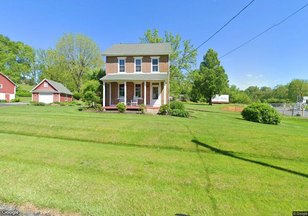
4151 Main Rd W Emmaus, PA 18049
Upper Milford Township NeighborhoodEstimated Value: $458,000 - $519,000
3
Beds
3
Baths
2,412
Sq Ft
$197/Sq Ft
Est. Value
About This Home
This home is located at 4151 Main Rd W, Emmaus, PA 18049 and is currently estimated at $474,414, approximately $196 per square foot. 4151 Main Rd W is a home located in Lehigh County with nearby schools including Macungie Elementary School, Eyer Middle School, and Emmaus High School.
Ownership History
Date
Name
Owned For
Owner Type
Purchase Details
Closed on
Sep 29, 1998
Sold by
Rinker Dale L and Rinker Jane G
Bought by
Brown Matthew W and Defrancisco Brown Beth A
Current Estimated Value
Purchase Details
Closed on
Sep 2, 1986
Sold by
Carraghan Dallett S and Carraghan Elsie E
Bought by
Rinker Dale L and Rinker Jane G
Purchase Details
Closed on
Aug 29, 1980
Bought by
Carraghan Dallett S and Carraghan Elsie E
Create a Home Valuation Report for This Property
The Home Valuation Report is an in-depth analysis detailing your home's value as well as a comparison with similar homes in the area
Home Values in the Area
Average Home Value in this Area
Purchase History
| Date | Buyer | Sale Price | Title Company |
|---|---|---|---|
| Brown Matthew W | $117,000 | -- | |
| Rinker Dale L | $87,000 | -- | |
| Carraghan Dallett S | -- | -- |
Source: Public Records
Tax History Compared to Growth
Tax History
| Year | Tax Paid | Tax Assessment Tax Assessment Total Assessment is a certain percentage of the fair market value that is determined by local assessors to be the total taxable value of land and additions on the property. | Land | Improvement |
|---|---|---|---|---|
| 2025 | $5,346 | $209,400 | $71,300 | $138,100 |
| 2024 | $5,109 | $209,400 | $71,300 | $138,100 |
| 2023 | $5,006 | $209,400 | $71,300 | $138,100 |
| 2022 | $4,886 | $209,400 | $138,100 | $71,300 |
| 2021 | $4,781 | $209,400 | $71,300 | $138,100 |
| 2020 | $4,735 | $209,400 | $71,300 | $138,100 |
| 2019 | $4,705 | $209,400 | $71,300 | $138,100 |
| 2018 | $4,585 | $209,400 | $71,300 | $138,100 |
| 2017 | $4,504 | $209,400 | $71,300 | $138,100 |
| 2016 | -- | $209,400 | $71,300 | $138,100 |
| 2015 | -- | $209,400 | $71,300 | $138,100 |
| 2014 | -- | $209,400 | $71,300 | $138,100 |
Source: Public Records
Map
Nearby Homes
- 4290 Taviston Ct E
- 4285 Taviston Ct E
- 4314 Taviston Ct E
- 4338 Taviston Ct E Unit Homesite 26
- 5065 Maple Ridge Way
- 5125 Maple Ridge Way
- 4434 Taviston Ct E
- 5095 Maple Ridge Way Unit Homesite 13
- 4441 Taviston Ct E
- Helena Plan at The Estates at Maple Ridge - Estate Series
- Anderson Plan at The Estates at Maple Ridge - Estate Series
- Wells Plan at The Estates at Maple Ridge - Classic Series
- Sutton Plan at The Estates at Maple Ridge - Estate Series
- Oakville Plan at The Estates at Maple Ridge - Estate Series
- Bennett Plan at The Estates at Maple Ridge - Classic Series
- Meadowood Plan at The Estates at Maple Ridge - Classic Series
- 4389 Taviston Ct E
- 5160 Maple Ridge Way
- 4481 Linda Ln
- 4835 Shimerville Rd