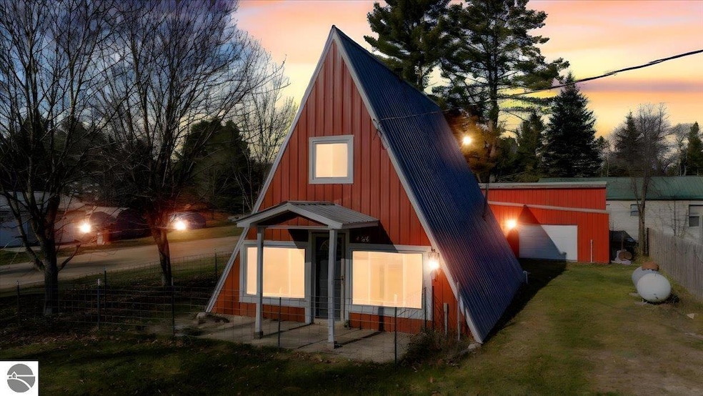
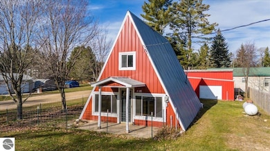
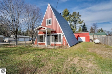
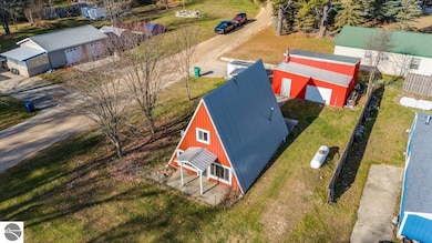
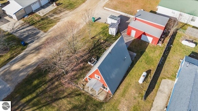
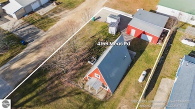
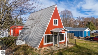
4156 Maes Rd West Branch, MI 48661
Estimated payment $745/month
Highlights
- A-Frame Home
- Forced Air Heating and Cooling System
- Heated Garage
- 2 Car Detached Garage
- Shed
About This Home
Charming A-Frame Home — Move-In Ready! This well-kept 2 bedroom, 1 bath A-Frame home offers easy, low-maintenance living on a manageable lot. The interior is very clean and move-in ready, featuring an updated bathroom and efficient floor plan with cozy character. Recent updates provide peace of mind, including a newer roof and new septic system. The home and garage are both spray-foam insulated, helping with energy efficiency year-round. Outside, you’ll appreciate the spacious 24x26 detached pole barn/garage — perfect for parking, storage, or workshop space. A great opportunity for a full-time residence, seasonal getaway, or investment property. Nothing to do but move in and enjoy! Walking distance to state land for hundreds of miles of ORV/ATV trails to explore! Conveniently Located 5 minutes to the 215 I-75 exit and 10 minutes to downtown West Branch for all your shopping and dining needs.
Home Details
Home Type
- Single Family
Est. Annual Taxes
- $710
Year Built
- Built in 1970
Lot Details
- 7,405 Sq Ft Lot
- Lot Dimensions are 120x60x120x60
- Cleared Lot
- The community has rules related to zoning restrictions
Home Design
- 950 Sq Ft Home
- A-Frame Home
- Slab Foundation
- Frame Construction
- Metal Roof
- Steel Siding
Bedrooms and Bathrooms
- 2 Bedrooms
- 1 Full Bathroom
Laundry
- Dryer
- Washer
Parking
- 2 Car Detached Garage
- Heated Garage
- Gravel Driveway
Utilities
- Forced Air Heating and Cooling System
- Well
Additional Features
- Oven or Range
- Shed
Community Details
- Ogemaw Springs Community
Map
Home Values in the Area
Average Home Value in this Area
Tax History
| Year | Tax Paid | Tax Assessment Tax Assessment Total Assessment is a certain percentage of the fair market value that is determined by local assessors to be the total taxable value of land and additions on the property. | Land | Improvement |
|---|---|---|---|---|
| 2025 | $710 | $34,200 | $0 | $0 |
| 2024 | $3 | $32,500 | $0 | $0 |
| 2023 | $319 | $29,600 | $0 | $0 |
| 2022 | $532 | $20,200 | $0 | $0 |
| 2021 | $552 | $19,400 | $0 | $0 |
| 2020 | $377 | $18,100 | $0 | $0 |
| 2019 | $553 | $17,100 | $0 | $0 |
| 2018 | $539 | $15,200 | $0 | $0 |
| 2017 | $497 | $12,500 | $0 | $0 |
| 2016 | $492 | $12,100 | $0 | $0 |
| 2015 | $491 | $13,400 | $0 | $0 |
| 2014 | $486 | $12,100 | $0 | $0 |
Property History
| Date | Event | Price | List to Sale | Price per Sq Ft |
|---|---|---|---|---|
| 11/20/2025 11/20/25 | For Sale | $129,900 | -- | $137 / Sq Ft |
Purchase History
| Date | Type | Sale Price | Title Company |
|---|---|---|---|
| Deed | $22,000 | -- | |
| Sheriffs Deed | $22,016 | -- |
Mortgage History
| Date | Status | Loan Amount | Loan Type |
|---|---|---|---|
| Open | $20,592 | No Value Available |
Source: Northern Great Lakes REALTORS® MLS
MLS Number: 1940681
APN: 011-102-012-00
Disclaimer: Certain information contained herein is derived from information provided by parties other than Homes.com. All information provided is deemed reliable, but is not guaranteed to be accurate and should be independently verified.
![]() The information in this listing was gathered from third-party sources including the seller. Northern Great Lakes REALTORS® MLS and its subscribers disclaim any and all representations or warranties as to the accuracy of this information.
The information in this listing was gathered from third-party sources including the seller. Northern Great Lakes REALTORS® MLS and its subscribers disclaim any and all representations or warranties as to the accuracy of this information.
Copyright 2025 Northern Great Lakes REALTORS® MLS. All Rights Reserved.
- 3428 Simon Dr
- 0 W M-76 Unit 1925090
- 0 W M-76 Unit 1905107
- 206 Highland St
- 4951 W M 76
- 324 N 4th St
- 227 N 1st St
- 315 S 4th St
- 240 N Burgess St
- 0 S First St Unit 1932836
- 106 S Valley St
- 195 Fremont St
- 0 Fairview Rd Unit 1939430
- 268 Windemere Place Unit 14B
- 272 Windemere Place Unit 14A
- 2301 Birchcrest Dr
- 2831 Pointer Rd
- 361 Irons Park Dr
- 2249 W State Rd
- Parcel 1 M-76
