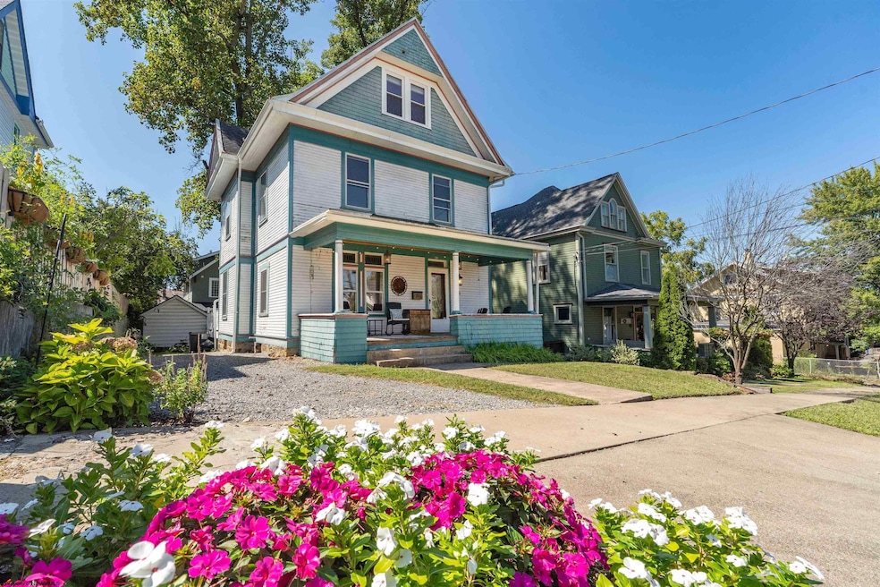
416 Cedar St Morgantown, WV 26501
South Park NeighborhoodEstimated payment $1,945/month
Highlights
- City Lights View
- Deck
- Finished Attic
- South Middle School Rated A-
- Wood Flooring
- Private Yard
About This Home
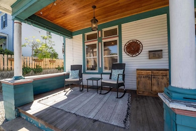
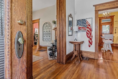
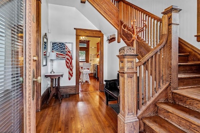
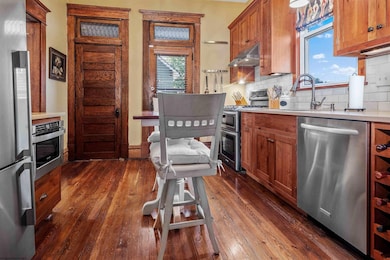
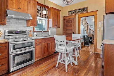
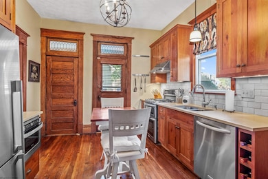
South Park Charm Meets Modern Comfort ? This beautifully maintained 4-bedroom, 1.5-bath home, built in 1900, offers timeless elegance with thoughtful updates. Original oak floors and woodwork, leaded glass windows, and pocket doors showcase the home?s historic character, while soaring ceilings add a sense of space and light. The inviting front porch, supported by three classic pillars, welcomes you home. Enjoy a fresh, modern kitchen and a dining area that opens to a shaded deck?perfect for morning coffee or evening entertaining. Retreat to a renovated bathroom with a double-sink vanity and unwind in the peacefully remodeled, air-conditioned third-floor suite. Ample off-street parking and a short jaunt to downtown amenities complete this perfect blend of classic charm and contemporary convenience. Don't miss your chance to see this wonderful home and make it yours today!
Listing Agent
BERKSHIRE HATHAWAY HOMESERVICES TOUCHDOWN HOME PROS REALTY License #WV0026273 Listed on: 10/02/2025

Co-Listing Agent
BERKSHIRE HATHAWAY HOMESERVICES TOUCHDOWN HOME PROS REALTY License #WV0020990
Home Details
Home Type
- Single Family
Est. Annual Taxes
- $1,636
Year Built
- Built in 1900
Lot Details
- 3,485 Sq Ft Lot
- Lot Dimensions are 45 x 75
- Level Lot
- Private Yard
- Historic Home
- Property is zoned Single Family Residential
Property Views
- City Lights
- Neighborhood
Home Design
- Stone Foundation
- Frame Construction
- Shingle Roof
- Wood Siding
- Shake Siding
Interior Spaces
- 2-Story Property
- Ceiling height of 9 feet or more
- Ceiling Fan
- Gas Log Fireplace
- Basement Fills Entire Space Under The House
- Finished Attic
- Fire and Smoke Detector
Kitchen
- Range
- Microwave
- Dishwasher
- Disposal
Flooring
- Wood
- Wall to Wall Carpet
Bedrooms and Bathrooms
- 4 Bedrooms
Laundry
- Dryer
- Washer
Parking
- 3 Car Parking Spaces
- Off-Street Parking
Outdoor Features
- Deck
- Outdoor Gas Grill
- Porch
Schools
- Mountainview Elementary School
- South Middle School
- Morgantown High School
Utilities
- Forced Air Zoned Cooling and Heating System
- Heat Pump System
- Heating System Uses Gas
- 200+ Amp Service
- Gas Water Heater
- Cable TV Available
Listing and Financial Details
- Assessor Parcel Number 36
Community Details
Overview
- No Home Owners Association
- South Park Subdivision
Amenities
- Public Transportation
- Community Library
Recreation
- Park
Map
Home Values in the Area
Average Home Value in this Area
Tax History
| Year | Tax Paid | Tax Assessment Tax Assessment Total Assessment is a certain percentage of the fair market value that is determined by local assessors to be the total taxable value of land and additions on the property. | Land | Improvement |
|---|---|---|---|---|
| 2025 | $1,679 | $127,320 | $39,240 | $88,080 |
| 2024 | $1,679 | $127,320 | $39,240 | $88,080 |
| 2023 | $1,675 | $106,740 | $39,240 | $67,500 |
| 2022 | $1,345 | $105,480 | $39,180 | $66,300 |
| 2021 | $1,350 | $105,480 | $39,180 | $66,300 |
| 2020 | $1,355 | $105,480 | $39,180 | $66,300 |
| 2019 | $1,363 | $105,480 | $39,180 | $66,300 |
| 2018 | $1,366 | $105,480 | $39,180 | $66,300 |
| 2017 | $1,280 | $98,400 | $36,960 | $61,440 |
| 2016 | $1,246 | $95,280 | $33,840 | $61,440 |
| 2015 | $1,164 | $92,340 | $30,900 | $61,440 |
| 2014 | $1,055 | $86,880 | $27,600 | $59,280 |
Property History
| Date | Event | Price | List to Sale | Price per Sq Ft |
|---|---|---|---|---|
| 10/02/2025 10/02/25 | For Sale | $342,475 | -- | $176 / Sq Ft |
Purchase History
| Date | Type | Sale Price | Title Company |
|---|---|---|---|
| Deed | $245,000 | None Available | |
| Deed | $184,000 | None Available |
Mortgage History
| Date | Status | Loan Amount | Loan Type |
|---|---|---|---|
| Open | $196,000 | New Conventional |
Source: North Central West Virginia REIN
MLS Number: 10161824
APN: 10-36-00360000
Disclaimer: Certain information contained herein is derived from information provided by parties other than Homes.com. All information provided is deemed reliable, but is not guaranteed to be accurate and should be independently verified.
![]() Data provided by North Central WV Real Estate Information Network, Inc.
Data provided by North Central WV Real Estate Information Network, Inc.
IDX information is provided exclusively for consumers’ personal non-commercial use and may not be used for any purpose other than to identify prospective properties consumers may be interested in purchasing.
- 420 St Unit L
- 327 Euclid Ave Unit B
- 208 Logan Ave
- 312 Cobun Ave Unit . 7
- 307 Cobun Ave Unit b
- 320 Cobun Ave Unit . 2
- 311 Cobun Ave Unit 311 Cobun Avenue
- 347 1/2 Kingwood St
- 405 Kingwood St
- 335 Kingwood St Unit 1
- 132 Simpson St Unit 2
- 52 High St
- 245 Green St
- 232 Reay Alley Unit 232
- 228 Riverview Ct
- 421 Pennsylvania Ave Unit ID1308979P
- 421 Pennsylvania Ave Unit ID1308983P
- 421 Pennsylvania Ave Unit ID1308950P
- 160 Pleasant St Unit 1
- 480 Dorsey Ave Unit A