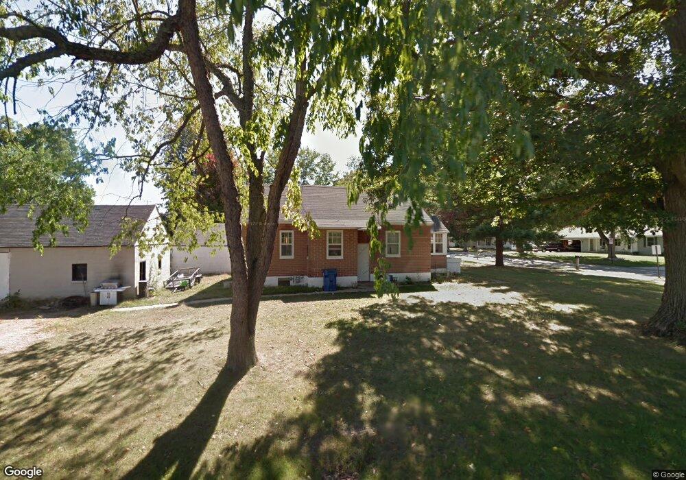
416 Forrest St Wayland, MI 49348
Estimated Value: $203,000 - $233,000
2
Beds
1
Bath
960
Sq Ft
$229/Sq Ft
Est. Value
About This Home
This home is located at 416 Forrest St, Wayland, MI 49348 and is currently estimated at $219,841, approximately $229 per square foot. 416 Forrest St is a home located in Allegan County with nearby schools including Wayland High School and St. Therese Catholic School.
Ownership History
Date
Name
Owned For
Owner Type
Purchase Details
Closed on
Jul 31, 2007
Sold by
Harnish Joseph L and Harnish Jessica M
Bought by
Misner Robert L and Misner Sarah M
Current Estimated Value
Home Financials for this Owner
Home Financials are based on the most recent Mortgage that was taken out on this home.
Original Mortgage
$97,500
Outstanding Balance
$62,141
Interest Rate
6.79%
Mortgage Type
Purchase Money Mortgage
Estimated Equity
$157,700
Purchase Details
Closed on
Sep 8, 2000
Sold by
Swift Michael and Deana
Bought by
Harnish Joseph and Stibbe Jessica
Purchase Details
Closed on
Jun 6, 1996
Sold by
Witherall June
Bought by
Swift Michael J and Marcinek Deana
Create a Home Valuation Report for This Property
The Home Valuation Report is an in-depth analysis detailing your home's value as well as a comparison with similar homes in the area
Home Values in the Area
Average Home Value in this Area
Purchase History
| Date | Buyer | Sale Price | Title Company |
|---|---|---|---|
| Misner Robert L | $97,500 | None Available | |
| Harnish Joseph | $94,400 | -- | |
| Swift Michael J | $47,000 | -- |
Source: Public Records
Mortgage History
| Date | Status | Borrower | Loan Amount |
|---|---|---|---|
| Open | Misner Robert L | $97,500 |
Source: Public Records
Tax History Compared to Growth
Tax History
| Year | Tax Paid | Tax Assessment Tax Assessment Total Assessment is a certain percentage of the fair market value that is determined by local assessors to be the total taxable value of land and additions on the property. | Land | Improvement |
|---|---|---|---|---|
| 2025 | $2,066 | $76,800 | $10,300 | $66,500 |
| 2024 | $1,879 | $69,600 | $8,300 | $61,300 |
| 2023 | $1,879 | $68,600 | $7,600 | $61,000 |
| 2022 | $1,879 | $62,100 | $7,600 | $54,500 |
| 2021 | $1,757 | $56,700 | $7,000 | $49,700 |
| 2020 | $1,757 | $53,800 | $7,000 | $46,800 |
| 2019 | $0 | $51,700 | $6,400 | $45,300 |
| 2018 | $0 | $51,500 | $6,400 | $45,100 |
| 2017 | $0 | $52,300 | $6,400 | $45,900 |
| 2016 | $0 | $44,500 | $7,000 | $37,500 |
| 2015 | -- | $44,500 | $7,000 | $37,500 |
| 2014 | -- | $39,400 | $7,000 | $32,400 |
| 2013 | -- | $35,500 | $7,000 | $28,500 |
Source: Public Records
Map
Nearby Homes
- 212 E Superior St
- 545 N Main St
- 146 Hanlon Ct
- 110 E Sycamore St
- 3610 Garden St
- 621 S Main St
- 219 Alpine St
- 319 Alpine St
- 3685 Calkins Ct
- 3770 Division Ave S
- 330 Lotz Ct
- 835 Wild Flower Ct
- 3570 Windsor Woods Dr
- 1143 Regina Trail
- 4674 12th St
- 3282 Stonehill Ct
- 3296 Stonehill Ct
- 3897 Division St
- 3214 7th St
- 3669 Kalamazoo Dr
- 324 Forrest St
- 112 Forrest St
- 325 N Locust St
- 320 Forrest St
- 420 Forrest St
- 323 N Locust St
- 225 E Elm St
- 331 Forrest St
- 424 Forrest St
- 321 Forrest St
- 343 Forrest St
- 321 N Locust St
- 409 Forrest St
- 319 Forrest St
- 426 Forrest St
- 411 Forrest St
- 315 Forrest St
- 310 Forrest St
- 215 E Cherry St
- 332 N Locust St