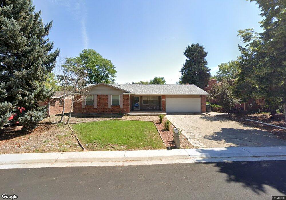
416 S Uvalda Cir Aurora, CO 80012
Aurora Hills NeighborhoodEstimated Value: $422,000 - $501,000
3
Beds
2
Baths
1,520
Sq Ft
$296/Sq Ft
Est. Value
About This Home
This home is located at 416 S Uvalda Cir, Aurora, CO 80012 and is currently estimated at $449,794, approximately $295 per square foot. 416 S Uvalda Cir is a home located in Arapahoe County with nearby schools including Virginia Court Elementary School, Aurora Hills Middle School, and Gateway High School.
Ownership History
Date
Name
Owned For
Owner Type
Purchase Details
Closed on
Jul 9, 1999
Sold by
Dean Hal
Bought by
Eubank Doreen L and Soltis Craig A
Current Estimated Value
Purchase Details
Closed on
Nov 16, 1992
Sold by
Eubank Doreen L and Soltis Craig A
Bought by
Eubank Hal Dean and Eubank Doreen
Purchase Details
Closed on
Oct 4, 1991
Sold by
City Savings & Resolution Trust Corp As
Bought by
Eubank Doreen L and Soltis Craig A
Purchase Details
Closed on
May 24, 1991
Sold by
Droll Shirley J Droll Thomas G
Bought by
City Savings & Resolution Trust Corp As
Purchase Details
Closed on
Dec 31, 1986
Sold by
Conversion Arapco
Bought by
Droll Shirley J Droll Thomas G
Purchase Details
Closed on
Jul 4, 1776
Bought by
Conversion Arapco
Create a Home Valuation Report for This Property
The Home Valuation Report is an in-depth analysis detailing your home's value as well as a comparison with similar homes in the area
Home Values in the Area
Average Home Value in this Area
Purchase History
| Date | Buyer | Sale Price | Title Company |
|---|---|---|---|
| Eubank Doreen L | $17,243 | -- | |
| Eubank Hal Dean | -- | -- | |
| Eubank Doreen L | -- | -- | |
| City Savings & Resolution Trust Corp As | -- | -- | |
| Droll Shirley J Droll Thomas G | -- | -- | |
| Conversion Arapco | -- | -- |
Source: Public Records
Tax History
| Year | Tax Paid | Tax Assessment Tax Assessment Total Assessment is a certain percentage of the fair market value that is determined by local assessors to be the total taxable value of land and additions on the property. | Land | Improvement |
|---|---|---|---|---|
| 2025 | $2,867 | $28,938 | -- | -- |
| 2024 | $2,781 | $29,922 | -- | -- |
| 2023 | $2,781 | $29,922 | $0 | $0 |
| 2022 | $2,404 | $23,943 | $0 | $0 |
| 2021 | $2,482 | $23,943 | $0 | $0 |
| 2020 | $2,219 | $21,314 | $0 | $0 |
| 2019 | $2,207 | $21,314 | $0 | $0 |
| 2018 | $2,050 | $19,390 | $0 | $0 |
| 2017 | $1,784 | $19,390 | $0 | $0 |
| 2016 | $1,324 | $14,097 | $0 | $0 |
| 2015 | $1,278 | $14,097 | $0 | $0 |
| 2014 | -- | $10,953 | $0 | $0 |
| 2013 | -- | $12,310 | $0 | $0 |
Source: Public Records
Map
Nearby Homes
- 365 S Ursula Way
- 429 S Victor Way
- 13086 E Alaska Ave
- 418 S Wheeling Way
- 373 S Troy St
- 12802 E Nevada Cir
- 12466 E Alaska Place
- 12446 E Alaska Place
- 12969 E Ohio Ave
- 12403 E Nevada Ave
- 12244 E Kentucky Ave
- 13675 E Kentucky Place
- 830 S Wheeling St
- 12170 E Kepner Place Unit 12170
- 12525 E Tennessee Cir Unit A
- 932 S Peoria St Unit 932
- 912 S Peoria St
- 12404 E Tennessee Cir Unit F
- 12404 E Tennessee Cir Unit E
- 12024 E Maple Ave
- 412 S Uvalda Cir
- 417 S Uvalda St
- 421 S Uvalda St
- 424 S Uvalda Cir
- 410 S Uvalda Cir
- 411 S Uvalda St
- 427 S Uvalda St
- 415 S Uvalda Cir
- 419 S Uvalda Cir
- 413 S Uvalda Cir
- 430 S Uvalda Cir
- 401 S Uvalda St
- 425 S Uvalda Cir
- 409 S Uvalda Cir
- 431 S Uvalda St
- 407 S Uvalda Cir
- 429 S Uvalda Cir
- 418 S Uvalda St
- 432 S Uvalda Cir
- 405 S Uvalda Cir
Your Personal Tour Guide
Ask me questions while you tour the home.