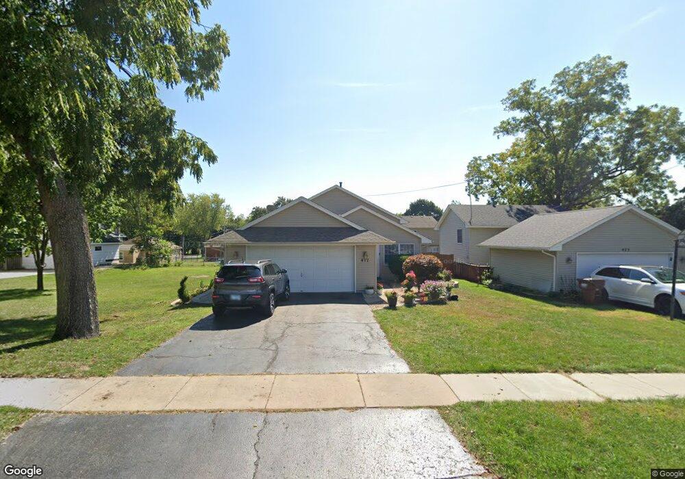
417 Forrest Ave Woodstock, IL 60098
Estimated Value: $247,000 - $270,238
3
Beds
2
Baths
1,143
Sq Ft
$227/Sq Ft
Est. Value
About This Home
This home is located at 417 Forrest Ave, Woodstock, IL 60098 and is currently estimated at $259,560, approximately $227 per square foot. 417 Forrest Ave is a home located in McHenry County with nearby schools including Dean Street Elementary School, Creekside Middle School, and Woodstock High School.
Ownership History
Date
Name
Owned For
Owner Type
Purchase Details
Closed on
Sep 28, 2000
Sold by
Natrop Sam W and Natrop Jill C
Bought by
Carbajal Juan and Bernal Emilia B
Current Estimated Value
Home Financials for this Owner
Home Financials are based on the most recent Mortgage that was taken out on this home.
Original Mortgage
$139,060
Outstanding Balance
$50,931
Interest Rate
7.98%
Mortgage Type
FHA
Estimated Equity
$208,629
Purchase Details
Closed on
Jun 12, 1997
Sold by
Natrop Sam V
Bought by
Natrop Sam W and Stephenson Jill C
Home Financials for this Owner
Home Financials are based on the most recent Mortgage that was taken out on this home.
Original Mortgage
$93,100
Interest Rate
8.01%
Purchase Details
Closed on
Jun 11, 1997
Sold by
Natrop Kecia M
Bought by
Natrop Sam W
Home Financials for this Owner
Home Financials are based on the most recent Mortgage that was taken out on this home.
Original Mortgage
$93,100
Interest Rate
8.01%
Create a Home Valuation Report for This Property
The Home Valuation Report is an in-depth analysis detailing your home's value as well as a comparison with similar homes in the area
Home Values in the Area
Average Home Value in this Area
Purchase History
| Date | Buyer | Sale Price | Title Company |
|---|---|---|---|
| Carbajal Juan | $140,000 | -- | |
| Natrop Sam W | -- | Chicago Title | |
| Natrop Sam W | -- | Chicago Title |
Source: Public Records
Mortgage History
| Date | Status | Borrower | Loan Amount |
|---|---|---|---|
| Open | Carbajal Juan | $139,060 | |
| Previous Owner | Natrop Sam W | $93,100 |
Source: Public Records
Tax History Compared to Growth
Tax History
| Year | Tax Paid | Tax Assessment Tax Assessment Total Assessment is a certain percentage of the fair market value that is determined by local assessors to be the total taxable value of land and additions on the property. | Land | Improvement |
|---|---|---|---|---|
| 2024 | $6,688 | $80,585 | $7,871 | $72,714 |
| 2023 | $6,346 | $72,875 | $7,118 | $65,757 |
| 2022 | $6,049 | $64,674 | $6,317 | $58,357 |
| 2021 | $5,744 | $60,426 | $5,902 | $54,524 |
| 2020 | $5,524 | $57,417 | $5,608 | $51,809 |
| 2019 | $5,355 | $54,808 | $5,353 | $49,455 |
| 2018 | $4,822 | $49,263 | $6,106 | $43,157 |
| 2017 | $4,721 | $46,365 | $5,747 | $40,618 |
| 2016 | $4,661 | $42,930 | $5,321 | $37,609 |
| 2013 | -- | $41,461 | $8,821 | $32,640 |
Source: Public Records
Map
Nearby Homes
- 104 Stewart Ave
- 125 Forest Ave
- 421 W Kimball Ave
- 415 Dean St
- 908 Bunker St
- 155 Lee Ann Ln
- 331 Chestnut St
- 1288 Prairie Ridge Trail
- 3848 Riverwoods Dr
- 3902 Riverwoods Dr
- 3842 Riverwoods Dr
- 3839 Riverwoods Dr
- Townsend Plan at Clublands of Antioch - Horizon Series
- Napa Plan at Clublands of Antioch - Andare Series
- 1249 Prairie Ridge Trail
- 3851 Riverwoods Dr
- 3827 Riverwoods Dr
- Meadowlark Plan at Clublands of Antioch - Horizon Series
- Rutherford Plan at Clublands of Antioch - Andare Series
- Starling Plan at Riverwoods - Single Family
- 423 Forrest Ave
- 407 Forrest Ave
- 427 Forrest Ave
- 427 Forest Ave
- 418 Stewart Ave
- 412 Stewart Ave
- 422 Stewart Ave
- 708 Mitchell St
- 406 Stewart Ave
- Lot 75 Forest Ave
- 400 Stewart Ave
- 704 Muriel St
- 790 Muriel St
- 323 Forrest Ave
- 507 Forrest Ave
- 506 Stewart Ave
- 711 Mitchell St
- 417 Stewart Ave
- 421 Stewart Ave