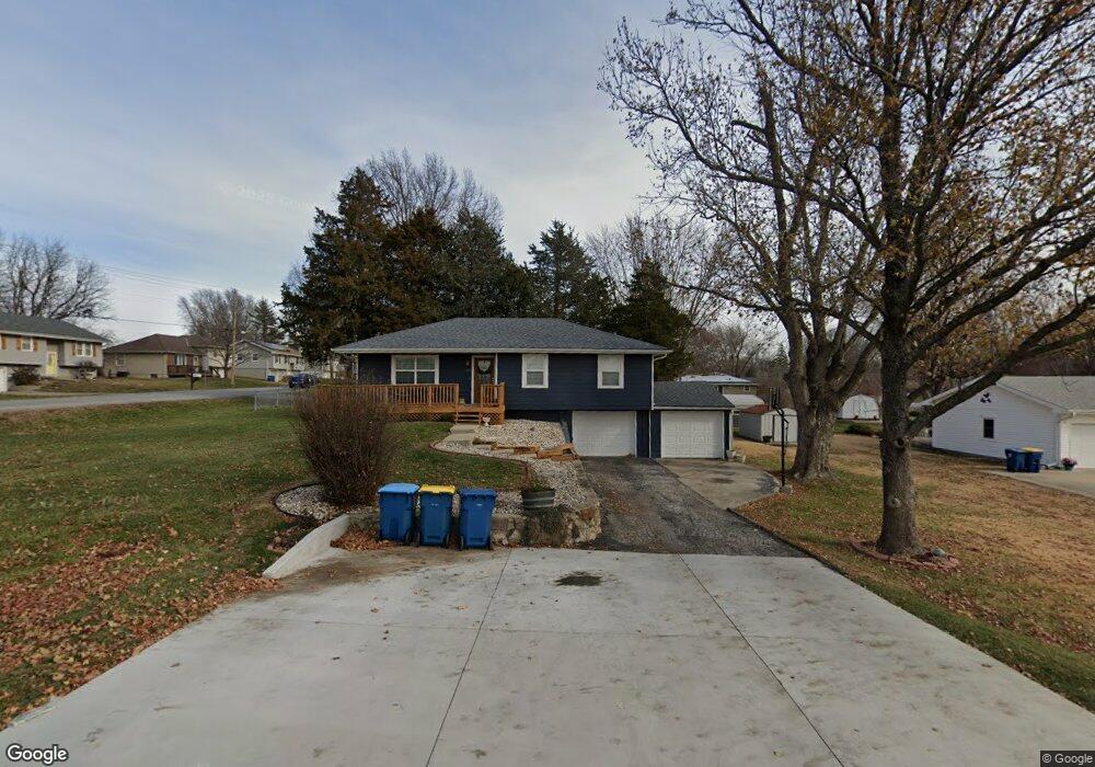
417 Lodwick Ln Excelsior Springs, MO 64024
Estimated Value: $220,442 - $243,000
3
Beds
1
Bath
1,052
Sq Ft
$219/Sq Ft
Est. Value
About This Home
This home is located at 417 Lodwick Ln, Excelsior Springs, MO 64024 and is currently estimated at $230,861, approximately $219 per square foot. 417 Lodwick Ln is a home located in Clay County with nearby schools including Excelsior Springs High School.
Ownership History
Date
Name
Owned For
Owner Type
Purchase Details
Closed on
May 11, 2017
Sold by
Emre Yunus
Bought by
Perez Desi Valentin and Perez Maria L
Current Estimated Value
Home Financials for this Owner
Home Financials are based on the most recent Mortgage that was taken out on this home.
Original Mortgage
$128,040
Outstanding Balance
$106,481
Interest Rate
4.1%
Mortgage Type
New Conventional
Estimated Equity
$124,380
Purchase Details
Closed on
Oct 22, 2014
Sold by
Dubin Marilyn J
Bought by
Emre Yunus
Purchase Details
Closed on
Jan 18, 2005
Sold by
Tabberer Robert D
Bought by
Dubin Douglas R and Dubin Marilyn J
Home Financials for this Owner
Home Financials are based on the most recent Mortgage that was taken out on this home.
Original Mortgage
$73,200
Interest Rate
5.68%
Mortgage Type
Purchase Money Mortgage
Create a Home Valuation Report for This Property
The Home Valuation Report is an in-depth analysis detailing your home's value as well as a comparison with similar homes in the area
Home Values in the Area
Average Home Value in this Area
Purchase History
| Date | Buyer | Sale Price | Title Company |
|---|---|---|---|
| Perez Desi Valentin | -- | Alpha Title Guaranty Inc | |
| Emre Yunus | -- | None Available | |
| Dubin Douglas R | -- | First American Title Ins Co |
Source: Public Records
Mortgage History
| Date | Status | Borrower | Loan Amount |
|---|---|---|---|
| Open | Perez Desi Valentin | $128,040 | |
| Previous Owner | Dubin Douglas R | $73,200 |
Source: Public Records
Tax History Compared to Growth
Tax History
| Year | Tax Paid | Tax Assessment Tax Assessment Total Assessment is a certain percentage of the fair market value that is determined by local assessors to be the total taxable value of land and additions on the property. | Land | Improvement |
|---|---|---|---|---|
| 2025 | $1,767 | $29,070 | -- | -- |
| 2024 | $1,767 | $25,190 | -- | -- |
| 2023 | $1,756 | $25,190 | $0 | $0 |
| 2022 | $1,241 | $17,520 | $0 | $0 |
| 2021 | $1,246 | $17,518 | $2,565 | $14,953 |
| 2020 | $1,197 | $16,360 | $0 | $0 |
| 2019 | $1,196 | $16,359 | $2,565 | $13,794 |
| 2018 | $1,065 | $14,520 | $0 | $0 |
| 2017 | $1,055 | $14,510 | $2,560 | $11,950 |
| 2016 | $1,039 | $14,510 | $2,560 | $11,950 |
| 2015 | $1,048 | $14,510 | $2,560 | $11,950 |
| 2014 | $1,058 | $14,510 | $2,560 | $11,950 |
Source: Public Records
Map
Nearby Homes
- 206 Crest Dr
- 617 Lodwick Ln
- 609 Kimberly Dr
- 106 Sunset Ln
- Lot 2 Wornall Rd
- 2017 Wornall Rd
- 2017 Karlton Way
- 2081 Rock Bridge Pkwy
- 125 Crown Hill Rd
- 2116 Bradford Place
- 240 Rock Bridge Pkwy
- 220 Rock Bridge Pkwy
- 2021 Riverstone Dr
- 1318 Kristie Cir
- 1104 Frontier St
- 112 Delores St
- 328 Virginia Rd
- 111 Collette St
- 2210 Piedmont Place
- 1101 Williams St
- 1807 Wornall Rd
- 415 Lodwick Ln
- 1806 Wornall Rd
- 1803 Wornall Rd
- 1804 Wornall Rd
- 411 Lodwick Ln
- 1900 Wornall Rd
- 1802 Wornall Rd
- 410 Zay Dr
- 414 Zay Dr
- 1800 Wornall Rd
- 1902 Wornall Rd
- 1807 Karlton Way
- 408 Zay Dr
- 1805 Karlton Way
- 409 Lodwick Ln
- 1803 Karlton Way
- 1901 Karlton Way
- 1720 Wornall Rd
- 1904 Wornall Rd