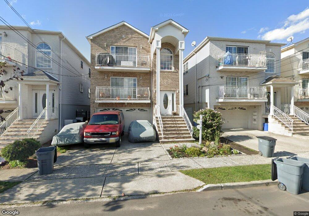
417 Loomis St Unit 419 Elizabethport, NJ 07206
Peters NeighborhoodEstimated Value: $818,721 - $927,000
7
Beds
5
Baths
4,500
Sq Ft
$193/Sq Ft
Est. Value
About This Home
This home is located at 417 Loomis St Unit 419, Elizabethport, NJ 07206 and is currently estimated at $867,930, approximately $192 per square foot. 417 Loomis St Unit 419 is a home located in Union County with nearby schools including Number 15, Christopher Columbus Elementary School and Elizabeth High School.
Ownership History
Date
Name
Owned For
Owner Type
Purchase Details
Closed on
Aug 22, 2005
Sold by
14 22 High Street Associates L
Bought by
Leber Kristen M and Leber Mary E
Current Estimated Value
Home Financials for this Owner
Home Financials are based on the most recent Mortgage that was taken out on this home.
Original Mortgage
$428,000
Interest Rate
6.4%
Create a Home Valuation Report for This Property
The Home Valuation Report is an in-depth analysis detailing your home's value as well as a comparison with similar homes in the area
Home Values in the Area
Average Home Value in this Area
Purchase History
| Date | Buyer | Sale Price | Title Company |
|---|---|---|---|
| Leber Kristen M | $535,000 | -- |
Source: Public Records
Mortgage History
| Date | Status | Borrower | Loan Amount |
|---|---|---|---|
| Previous Owner | Leber Kristen M | $428,000 |
Source: Public Records
Tax History Compared to Growth
Tax History
| Year | Tax Paid | Tax Assessment Tax Assessment Total Assessment is a certain percentage of the fair market value that is determined by local assessors to be the total taxable value of land and additions on the property. | Land | Improvement |
|---|---|---|---|---|
| 2025 | $13,276 | $690,000 | $164,500 | $525,500 |
| 2024 | $16,941 | $690,000 | $164,500 | $525,500 |
| 2023 | $16,941 | $53,900 | $12,300 | $41,600 |
| 2022 | $16,482 | $53,900 | $12,300 | $41,600 |
| 2021 | $16,142 | $53,900 | $12,300 | $41,600 |
| 2020 | $15,777 | $53,900 | $12,300 | $41,600 |
| 2019 | $15,536 | $53,900 | $12,300 | $41,600 |
| 2018 | $15,385 | $53,900 | $12,300 | $41,600 |
| 2017 | $14,956 | $53,900 | $12,300 | $41,600 |
| 2016 | $15,234 | $54,900 | $12,300 | $42,600 |
| 2015 | $14,328 | $54,900 | $12,300 | $42,600 |
| 2014 | -- | $54,900 | $12,300 | $42,600 |
Source: Public Records
Map
Nearby Homes
- 313 Loomis St
- 325 Spencer St
- 315 S 5th St
- 429 Niles St Unit 431
- 433 3rd Ave
- 234 Niles St
- 232 Niles St
- 220 Palmer St
- 227 Palmer St
- 221 Palmer St
- 336 John St Unit 340
- 316-318 John St
- 31 Spencer St
- 619B Arnett St
- 28 Niles St
- 566 2nd Ave
- 624B Clarkson Ave
- 234 Lt Glenn Zamorski Dr Unit G
- 230 Christine St Unit 32
- 225 Delaware St
- 415 Loomis St
- 421 Loomis St
- 413 Loomis St
- 423 Loomis St Unit 425
- 411 Loomis St
- 412 S 5th St
- 414 S 5th St
- 414 S 5th St Unit 2
- 416 S 5th St Unit Rear
- 416 S 5th St
- 410 S 5th St
- 408 S 5th St
- 427 Loomis St Unit 429
- 418 S 5th St Unit 420
- 406 S 5th St
- 464 4th Ave
- 462 4th Ave
- 466 4th Ave
- 422 S 5th St Unit 424
- 460 4th Ave