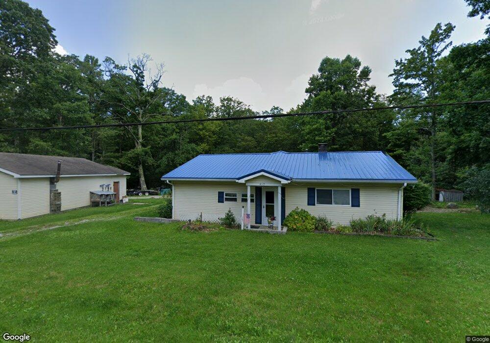
417 Maple Summit Rd Mill Run, PA 15464
Estimated Value: $146,000 - $176,000
3
Beds
1
Bath
1,120
Sq Ft
$139/Sq Ft
Est. Value
About This Home
This home is located at 417 Maple Summit Rd, Mill Run, PA 15464 and is currently estimated at $155,572, approximately $138 per square foot. 417 Maple Summit Rd is a home located in Fayette County with nearby schools including Uniontown Area Senior High School.
Ownership History
Date
Name
Owned For
Owner Type
Purchase Details
Closed on
Nov 1, 2024
Sold by
Durst Amber L
Bought by
Alpine Property Rentals Llc
Current Estimated Value
Home Financials for this Owner
Home Financials are based on the most recent Mortgage that was taken out on this home.
Original Mortgage
$116,000
Outstanding Balance
$114,839
Interest Rate
6.09%
Mortgage Type
New Conventional
Estimated Equity
$40,733
Purchase Details
Closed on
Mar 8, 2006
Sold by
Hardy Ronald W and Hardy Margaret L
Bought by
Durst Amber L
Home Financials for this Owner
Home Financials are based on the most recent Mortgage that was taken out on this home.
Original Mortgage
$88,511
Interest Rate
6.4%
Mortgage Type
FHA
Create a Home Valuation Report for This Property
The Home Valuation Report is an in-depth analysis detailing your home's value as well as a comparison with similar homes in the area
Home Values in the Area
Average Home Value in this Area
Purchase History
| Date | Buyer | Sale Price | Title Company |
|---|---|---|---|
| Alpine Property Rentals Llc | $145,000 | None Listed On Document | |
| Durst Amber L | $89,900 | None Available |
Source: Public Records
Mortgage History
| Date | Status | Borrower | Loan Amount |
|---|---|---|---|
| Open | Alpine Property Rentals Llc | $116,000 | |
| Previous Owner | Durst Amber L | $88,511 |
Source: Public Records
Tax History
| Year | Tax Paid | Tax Assessment Tax Assessment Total Assessment is a certain percentage of the fair market value that is determined by local assessors to be the total taxable value of land and additions on the property. | Land | Improvement |
|---|---|---|---|---|
| 2025 | $428 | $16,730 | $7,410 | $9,320 |
| 2024 | $408 | $16,730 | $7,410 | $9,320 |
| 2023 | $817 | $16,730 | $7,410 | $9,320 |
| 2022 | $817 | $16,730 | $7,410 | $9,320 |
| 2021 | $817 | $16,730 | $7,410 | $9,320 |
| 2020 | $798 | $16,730 | $7,410 | $9,320 |
| 2019 | $740 | $16,730 | $7,410 | $9,320 |
| 2018 | $701 | $16,730 | $7,410 | $9,320 |
| 2017 | $701 | $16,730 | $7,410 | $9,320 |
| 2016 | -- | $16,730 | $7,410 | $9,320 |
| 2015 | -- | $16,730 | $7,410 | $9,320 |
| 2014 | -- | $33,460 | $14,820 | $18,640 |
Source: Public Records
Map
Nearby Homes
- 0 Stewarton Rd Unit 1737788
- 0 Odonnal Rd Unit 1737793
- Lot 4 Cranberry Rd
- 17 Farm Ln
- 100 Jersey Hollow Rd
- 0 Greenbriar Rd
- 505 Greenbriar Rd
- 626 Sterner St
- 631 Meyers St
- 255 Smith School Rd
- 829 Oden St
- 833 Oden St
- 552 Chalk Hl Ohpyl Rd
- SR 653 Scullton Rd
- 192 Hawkins Hollow Rd
- 0 Earl Ansell Rd Lot Unit WP001
- 0 Rogers Mill Rd
- Greenbriar Rd
- 0 Earl Ansell Rd
- 135 Sandy Flat Rd
- 435 Maple Summit Rd
- 392 Maple Summit Rd
- 432 Maple Summit Rd
- 403 Maple Summit Rd
- 433 Maple Summit Rd
- 437 Maple Summit Rd
- 387 Maple Summit Rd
- 441 Maple Summit Rd
- 449 Maple Summit Rd
- 440 Maple Summit Rd
- 469 Maple Summit Rd
- 475 Maple Summit Rd
- 466 Maple Summit Rd
- 250 Maple Summit Rd
- 0 Maple Summit Rd
- Lot #1 Maple Summit Rd
- 00 Maple Summit Rd
- 517 Maple Summit Rd
- 0 Burnworth Rd
- 300 Maple Summit Rd