Estimated Value: $227,648 - $248,000
3
Beds
1
Bath
1,198
Sq Ft
$200/Sq Ft
Est. Value
About This Home
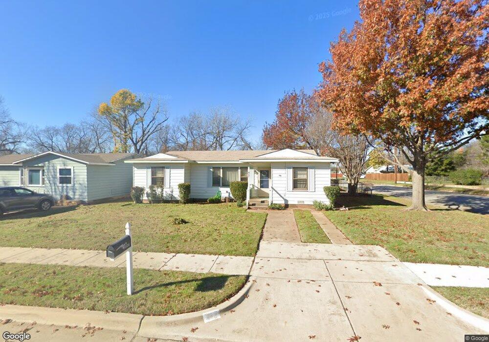
This home is located at 417 Michael Blvd, Hurst, TX 76053 and is currently estimated at $240,162, approximately $200 per square foot. 417 Michael Blvd is a home located in Tarrant County with nearby schools including Bellaire Elementary School, Hurst J High School, and L.D. Bell High School.
Ownership History
Date
Name
Owned For
Owner Type
Purchase Details
Closed on
Mar 28, 2014
Sold by
Gant Dorothy L
Bought by
Vasquez Daniela R
Current Estimated Value
Home Financials for this Owner
Home Financials are based on the most recent Mortgage that was taken out on this home.
Original Mortgage
$62,161
Outstanding Balance
$47,973
Interest Rate
4.75%
Mortgage Type
FHA
Estimated Equity
$192,189
Purchase Details
Closed on
Oct 10, 2011
Sold by
Gant Dorothy Lee
Bought by
Gant Dorothy L
Create a Home Valuation Report for This Property
The Home Valuation Report is an in-depth analysis detailing your home's value as well as a comparison with similar homes in the area
Home Values in the Area
Average Home Value in this Area
Purchase History
| Date | Buyer | Sale Price | Title Company |
|---|---|---|---|
| Vasquez Daniela R | -- | None Available | |
| Gant Dorothy L | -- | None Available |
Source: Public Records
Mortgage History
| Date | Status | Borrower | Loan Amount |
|---|---|---|---|
| Open | Vasquez Daniela R | $62,161 |
Source: Public Records
Tax History
| Year | Tax Paid | Tax Assessment Tax Assessment Total Assessment is a certain percentage of the fair market value that is determined by local assessors to be the total taxable value of land and additions on the property. | Land | Improvement |
|---|---|---|---|---|
| 2025 | $4,295 | $210,268 | $50,000 | $160,268 |
| 2024 | $4,295 | $210,268 | $50,000 | $160,268 |
| 2023 | $3,781 | $188,734 | $35,000 | $153,734 |
| 2022 | $4,290 | $186,343 | $35,000 | $151,343 |
| 2021 | $4,318 | $179,024 | $35,000 | $144,024 |
| 2020 | $3,413 | $141,850 | $35,000 | $106,850 |
| 2019 | $3,324 | $135,803 | $35,000 | $100,803 |
| 2018 | $2,606 | $106,465 | $15,000 | $91,465 |
| 2017 | $2,381 | $94,104 | $15,000 | $79,104 |
| 2016 | $2,217 | $87,597 | $15,000 | $72,597 |
| 2015 | $39 | $50,800 | $15,000 | $35,800 |
| 2014 | $39 | $50,800 | $15,000 | $35,800 |
Source: Public Records
Map
Nearby Homes
- 42 Page St
- 413 Wanda Way
- 308 Wanda Way
- 212 E Ellen Ave
- 312 E Ellen Ave
- 705 Timbercreek Dr
- 260 Corinna Ct
- 108 Donald Dr
- 205 Corinna Ct
- 740 Shady Ln
- 47 Donald Ct
- 408 Harrison Ln
- 552 Norwood Dr
- 4106 Hollow Oak Dr
- 1302 Woodridge Cir
- 609 Norwood Dr
- 840 Forest Hollow Dr
- 1309 Driftwood Dr
- 701 Harrison Ln
- 231 Elm St
- 413 Michael Blvd
- 409 Michael Blvd
- 425 Michael Blvd
- 50 Page St
- 405 Michael Blvd
- 46 Page St
- 200 Page Ct
- 416 Michael Blvd
- 429 Michael Blvd
- 412 Michael Blvd
- 424 Michael Blvd
- 408 Michael Blvd
- 401 Michael Blvd
- 204 Page Ct
- 433 Michael Blvd
- 404 Michael Blvd
- 428 Michael Blvd
- 38 Page St
- 503 Bluebonnet Dr
- 208 Page Ct
Your Personal Tour Guide
Ask me questions while you tour the home.