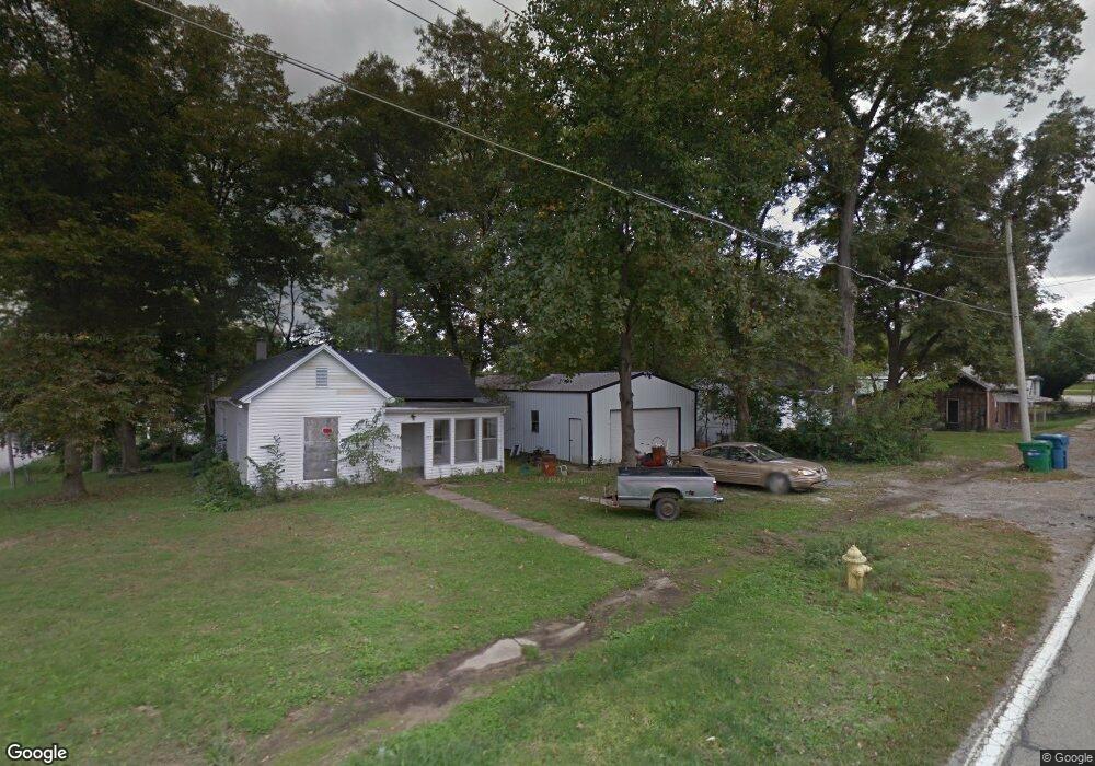
417 N State Rd Grayville, IL 62844
Estimated Value: $47,000
--
Bed
--
Bath
--
Sq Ft
0.3
Acres
About This Home
This home is located at 417 N State Rd, Grayville, IL 62844 and is currently estimated at $47,000. 417 N State Rd is a home located in Edwards County with nearby schools including Wells Elementary School and Grayville Junior/Senior High School.
Ownership History
Date
Name
Owned For
Owner Type
Purchase Details
Closed on
Jun 5, 2024
Sold by
Parr Charles R
Bought by
Klaus Dustan Lloyd
Current Estimated Value
Purchase Details
Closed on
Aug 29, 2023
Sold by
Krankel John A and Krankel Paula K
Bought by
Parr Charles R
Purchase Details
Closed on
Mar 12, 2012
Sold by
Krankel Paula K
Bought by
Rogers Mark and Rogers Jessica
Purchase Details
Closed on
Feb 9, 2011
Sold by
Sullivan Audrey
Bought by
Krankel Paula K
Purchase Details
Closed on
Jan 3, 2007
Sold by
Richardson William and Richardson Mary
Bought by
Krankel Paula K
Create a Home Valuation Report for This Property
The Home Valuation Report is an in-depth analysis detailing your home's value as well as a comparison with similar homes in the area
Home Values in the Area
Average Home Value in this Area
Purchase History
| Date | Buyer | Sale Price | Title Company |
|---|---|---|---|
| Klaus Dustan Lloyd | -- | None Listed On Document | |
| Klaus Dustan Lloyd | -- | None Listed On Document | |
| Parr Charles R | $5,000 | None Listed On Document | |
| Parr Charles R | $5,000 | None Listed On Document | |
| Rogers Mark | -- | -- | |
| Krankel Paula K | -- | -- | |
| Krankel Paula K | -- | -- |
Source: Public Records
Tax History Compared to Growth
Tax History
| Year | Tax Paid | Tax Assessment Tax Assessment Total Assessment is a certain percentage of the fair market value that is determined by local assessors to be the total taxable value of land and additions on the property. | Land | Improvement |
|---|---|---|---|---|
| 2024 | -- | $0 | $0 | $0 |
| 2023 | $277 | $0 | $0 | $0 |
| 2022 | $260 | $2,430 | $1,470 | $960 |
| 2021 | $260 | $2,460 | $1,490 | $970 |
| 2020 | $3 | $5,042 | $1,440 | $3,602 |
| 2019 | $29 | $5,375 | $1,535 | $3,840 |
| 2018 | $28 | $5,540 | $1,580 | $3,960 |
| 2017 | $63 | $5,715 | $1,630 | $4,085 |
| 2016 | $60 | $5,715 | $1,630 | $4,085 |
| 2015 | $640 | $5,395 | $1,540 | $3,855 |
| 2014 | $649 | $5,395 | $1,540 | $3,855 |
| 2013 | $30 | $5,240 | $1,495 | $3,745 |
| 2012 | $631 | $5,240 | $1,495 | $3,745 |
Source: Public Records
Map
Nearby Homes
- 531 Cemetery Rd
- 121 W Martin St
- 116 E North St
- 127 W Butler St
- 420 S Main St
- 201 Mulberry St
- 0 S 1850 Rd W Unit 202431574
- 801 Fifer Hills Rd
- 128 S Main St
- 873 Cr 850 N
- 1972 Cr 1985 N
- 201 Elliott St
- 505 Fourth St
- 337 S 2nd St
- 336 Co Rd 1980e
- 247 S 5th St
- 226 W Terminal St
- 0000 E Monet Rd
- 16 S 3rd St
- 124 W Cherry St